
| Memorials | : | 0 |
| Location | : | Stommeln, Rhein-Erft-Kreis, Germany |
| Coordinate | : | 51.0215670, 6.7601838 |
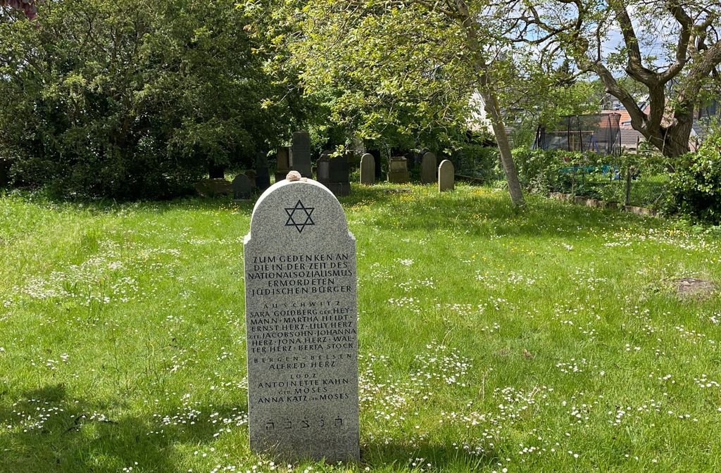
| Description | : | It is unknown when the Jewish Cemetery in Stommeln (Pulheim-Stommeln) was first used, most likely before the year 1861. The cemetery saw its last burial in 1937 and was partly destroyed during the Nazi regime. Today, the cemetery is no longer in use and is maintained by the local authorities. |
frequently asked questions (FAQ):
-
Where is Jewish Cemetery?
Jewish Cemetery is located at Nagelschmiedstrasse 12 Stommeln, Rhein-Erft-Kreis ,Nordrhein-Westfalen ,Germany.
-
Jewish Cemetery cemetery's updated grave count on graveviews.com?
0 memorials
-
Where are the coordinates of the Jewish Cemetery?
Latitude: 51.0215670
Longitude: 6.7601838
Nearby Cemetories:
1. Friedhof Esch
Cologne, Stadtkreis Köln, Germany
Coordinate: 51.0166700, 6.8573400
2. Brauweiler Abbey
Pulheim, Rhein-Erft-Kreis, Germany
Coordinate: 50.9611400, 6.7828300
3. Katholischer Friedhof Roggendorf Thenhoven
Cologne, Stadtkreis Köln, Germany
Coordinate: 51.0459100, 6.8534200
4. Brauweiler Cemetery
Pulheim, Rhein-Erft-Kreis, Germany
Coordinate: 50.9581130, 6.7753765
5. Waldfriedhof
Oberaussem, Rhein-Erft-Kreis, Germany
Coordinate: 50.9700860, 6.6877530
6. Friedhof Bergheim
Bergheim, Rhein-Sieg-Kreis, Germany
Coordinate: 50.9723430, 6.6827380
7. Friedhof Straberg
Straberg, Rhein Kreis Neuss, Germany
Coordinate: 51.0923542, 6.7591897
8. Friedhof Hauptstraße Widdersdorf neu
Cologne, Stadtkreis Köln, Germany
Coordinate: 50.9653200, 6.8291100
9. Friedhof Turmgasse Widdersdorf alt
Cologne, Stadtkreis Köln, Germany
Coordinate: 50.9635800, 6.8274900
10. Friedhof Worringen
Cologne, Stadtkreis Köln, Germany
Coordinate: 51.0624400, 6.8586800
11. Friedhof Chorweiler
Cologne, Stadtkreis Köln, Germany
Coordinate: 51.0180700, 6.8798500
12. Friedhof Pesch
Cologne, Stadtkreis Köln, Germany
Coordinate: 50.9989600, 6.8751400
13. Kleinkönigsdorfer Friedhof
Königsdorf, Rhein-Erft-Kreis, Germany
Coordinate: 50.9430976, 6.7651562
14. Friedhof Bocklemünd
Cologne, Stadtkreis Köln, Germany
Coordinate: 50.9750000, 6.8611560
15. Friedhof Volkhoven-Weiler
Cologne, Stadtkreis Köln, Germany
Coordinate: 51.0222500, 6.8861300
16. Dormagen
Dormagen, Rhein Kreis Neuss, Germany
Coordinate: 51.0914300, 6.8219500
17. Friedhof Lövenich
Cologne, Stadtkreis Köln, Germany
Coordinate: 50.9432800, 6.8183800
18. Jüdischer Friedhof Bocklmünd
Cologne, Stadtkreis Köln, Germany
Coordinate: 50.9705490, 6.8714300
19. Friedhof Königsdorf-Süd
Frechen, Rhein-Erft-Kreis, Germany
Coordinate: 50.9328850, 6.7749860
20. Westfriedhof
Cologne, Stadtkreis Köln, Germany
Coordinate: 50.9718330, 6.8786430
21. Friedhof Albert-Kindle-Straße Weiden neu
Cologne, Stadtkreis Köln, Germany
Coordinate: 50.9404000, 6.8209600
22. Friedhof Gartenweg Weiden alt
Cologne, Stadtkreis Köln, Germany
Coordinate: 50.9402200, 6.8287500
23. Friedhof Fühlingen
Cologne, Stadtkreis Köln, Germany
Coordinate: 51.0351500, 6.9066600
24. Friedhof Longerich
Cologne, Stadtkreis Köln, Germany
Coordinate: 50.9955700, 6.9113000