
| Memorials | : | 2 |
| Location | : | Keynsham, Bath and North East Somerset Unitary Authority, England |
| Coordinate | : | 51.4172000, -2.4961000 |
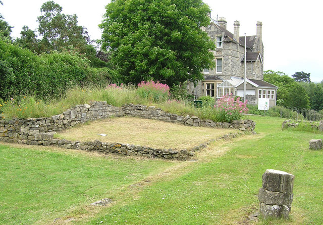
| Description | : | Keynsham Abbey in Keynsham, Somerset, England was founded by William, Earl of Gloucester for the Augustinian Canons Regular around 1170 and survived until 1539. After the dissolution in 1539, when the abbey and its possessions were surrendered to Henry VIII, the site was occupied by a house built by the Bridges family. In 1559 Thomas Bridges bequeathed stone from the late Abbey Church for the repair of the Bridge and causeway over the nearby River Avon.The house built by the Bridges family was demolished in 1776. The arms of the abbey included six golden clarions or trumpets on a red ground, from... Read More |
frequently asked questions (FAQ):
-
Where is Keynsham Abbey?
Keynsham Abbey is located at Keynsham, Bath and North East Somerset Unitary Authority ,Somerset ,England.
-
Keynsham Abbey cemetery's updated grave count on graveviews.com?
2 memorials
-
Where are the coordinates of the Keynsham Abbey?
Latitude: 51.4172000
Longitude: -2.4961000
Nearby Cemetories:
1. St. John the Baptist Churchyard
Keynsham, Bath and North East Somerset Unitary Authority, England
Coordinate: 51.4174570, -2.4987140
2. Ebenezer Baptist Church
Keynsham, Bath and North East Somerset Unitary Authority, England
Coordinate: 51.4160710, -2.4983170
3. Keynsham Cemetery
Keynsham, Bath and North East Somerset Unitary Authority, England
Coordinate: 51.4212975, -2.5116095
4. St. Mary Churchyard
Bitton, South Gloucestershire Unitary Authority, England
Coordinate: 51.4223600, -2.4599100
5. St Anne Churchyard
Oldland, South Gloucestershire Unitary Authority, England
Coordinate: 51.4381800, -2.4780900
6. Queen Charlton St. Margaret Churchyard
Compton Dando, Bath and North East Somerset Unitary Authority, England
Coordinate: 51.4009300, -2.5271800
7. Saint Margaret Churchyard
Compton Dando, Bath and North East Somerset Unitary Authority, England
Coordinate: 51.4009330, -2.5272136
8. Blessed Virgin Mary Churchyard
Saltford, Bath and North East Somerset Unitary Authority, England
Coordinate: 51.4056845, -2.4528274
9. Hanham Baptist Church Cemetery
Hanham, South Gloucestershire Unitary Authority, England
Coordinate: 51.4474802, -2.5107480
10. Saint Michael Churchyard
Keynsham, Bath and North East Somerset Unitary Authority, England
Coordinate: 51.3865690, -2.4830350
11. Brislington Cemetery
Brislington, Bristol Unitary Authority, England
Coordinate: 51.4355480, -2.5438020
12. Christ Church Churchyard
Hanham, South Gloucestershire Unitary Authority, England
Coordinate: 51.4484992, -2.5222650
13. Ebenezer Methodist Chapel
Warmley, South Gloucestershire Unitary Authority, England
Coordinate: 51.4514960, -2.4779637
14. Hanham United Reform Church Cemetery
Hanham, South Gloucestershire Unitary Authority, England
Coordinate: 51.4509706, -2.5189809
15. Blessed Virgin Mary Churchyard
Compton Dando, Bath and North East Somerset Unitary Authority, England
Coordinate: 51.3796870, -2.5100920
16. Whitchurch Cemetery
Bristol Unitary Authority, England
Coordinate: 51.3990278, -2.5506809
17. St. Nicholas Churchyard
Kelston, Bath and North East Somerset Unitary Authority, England
Coordinate: 51.4006420, -2.4344010
18. Christ Church Churchyard
Bristol, Bristol Unitary Authority, England
Coordinate: 51.4213270, -2.5632460
19. St. Barnabas Church of England Churchyard
Bristol, Bristol Unitary Authority, England
Coordinate: 51.4570643, -2.4704304
20. St. Martin Churchyard
Northstoke, Bath and North East Somerset Unitary Authority, England
Coordinate: 51.4202400, -2.4273800
21. St. Barnabas Churchyard
Warmley, South Gloucestershire Unitary Authority, England
Coordinate: 51.4570800, -2.4704100
22. Holy Trinity Churchyard
Kingswood, South Gloucestershire Unitary Authority, England
Coordinate: 51.4619990, -2.5040620
23. Master's Church Cemetery
Kingswood, South Gloucestershire Unitary Authority, England
Coordinate: 51.4630871, -2.5068932
24. All Saints Churchyard
Corston, Bath and North East Somerset Unitary Authority, England
Coordinate: 51.3857350, -2.4400372