
| Memorials | : | 0 |
| Location | : | Weltenburg, Landkreis Kelheim, Germany |
| Coordinate | : | 48.8989360, 11.8203130 |
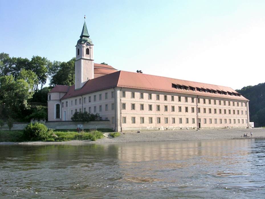
| Description | : | The Benedictine abbey of Weltenburg is the oldest monastery in Bavaria and was founded around 600 AD. by the monks of St. Columbanus. It is situated near the entrance to the scenic Danube gorge, on the northern slopes of the Arzberg mountain, near the site of the ancient Celtic settlement of Artobriga. The baroque church was built by the architect brothers Cosmas Damian Asam and Aegid Quirin Asam. Work began in 1716 by order of Maurus Baechl, Abbot of Weltenburg from 1713 to 1743; the entrance hall completing the building was finished in 1751 by Franz Anton Neu. In the abbey... Read More |
frequently asked questions (FAQ):
-
Where is Kloster Weltenburg?
Kloster Weltenburg is located at Weltenburg, Landkreis Kelheim ,Bavaria (Bayern) , 93309Germany.
-
Kloster Weltenburg cemetery's updated grave count on graveviews.com?
0 memorials
-
Where are the coordinates of the Kloster Weltenburg?
Latitude: 48.8989360
Longitude: 11.8203130
Nearby Cemetories:
1. Waldfriedhof Kelheim
Kelheim, Landkreis Kelheim, Germany
Coordinate: 48.9106500, 11.8587500
2. Friedhof Holzharlanden
Holzharlanden, Landkreis Kelheim, Germany
Coordinate: 48.8651500, 11.8368400
3. Alter Friedhof Kelheim
Kelheim, Landkreis Kelheim, Germany
Coordinate: 48.9200000, 11.8801800
4. Friedhof Kelheimwinzer
Kelheimwinzer, Landkreis Kelheim, Germany
Coordinate: 48.9138000, 11.9085700
5. St. Sebastian Kirche
Sandharlanden, Landkreis Kelheim, Germany
Coordinate: 48.8389500, 11.8208200
6. Friedhof Sandharlanden
Sandharlanden, Landkreis Kelheim, Germany
Coordinate: 48.8367800, 11.8244900
7. Friedhof Saal Donau
Saal an der Donau, Landkreis Kelheim, Germany
Coordinate: 48.9008500, 11.9396400
8. Friedhof Abendsberg
Schwaighausen, Landkreis Regensburg, Germany
Coordinate: 48.8180238, 11.8380722
9. Friedhof Abensberg
Abensberg, Landkreis Kelheim, Germany
Coordinate: 48.8177900, 11.8382200
10. Kloster Biburg
Biburg, Landkreis Kelheim, Germany
Coordinate: 48.7921690, 11.8566110
11. Friedhof Offenstetten
Abensberg, Landkreis Kelheim, Germany
Coordinate: 48.8033630, 11.9098060
12. Friedhof Kapfelberg
Kapfelberg, Landkreis Kelheim, Germany
Coordinate: 48.9313645, 11.9841941
13. Friedhof Mindelstetten
Mindelstetten, Landkreis Eichstätt, Germany
Coordinate: 48.8493990, 11.6512910
14. Friedhof Viehhausen
Viehhausen, Landkreis Regensburg, Germany
Coordinate: 48.9799884, 11.9625860
15. Pfarrkirche Mindelstetten
Mindelstetten, Landkreis Eichstätt, Germany
Coordinate: 48.8501480, 11.6439630
16. Friedhof Bergmatting
Bergmatting, Landkreis Regensburg, Germany
Coordinate: 48.9692808, 11.9813400
17. Friedhof Hüttenhausen
Hüttenhausen, Landkreis Eichstätt, Germany
Coordinate: 48.8484900, 11.6207100
18. Kirchlicher Friedhof Eilsbrunn
Eilsbrunn, Landkreis Regensburg, Germany
Coordinate: 49.0044463, 11.9752872
19. Friedhof Sankt Salvator
Hemau, Landkreis Regensburg, Germany
Coordinate: 49.0507341, 11.7864256
20. Friedhof Nittendorf
Nittendorf, Landkreis Regensburg, Germany
Coordinate: 49.0252320, 11.9604270
21. Friedhof Abbach
Bad Abbach, Landkreis Kelheim, Germany
Coordinate: 48.9350284, 12.0521349
22. Friedhof Sinzing
Sinzing, Landkreis Regensburg, Germany
Coordinate: 48.9929001, 12.0343558
23. Friedhof Theißing
Theissing, Landkreis Eichstätt, Germany
Coordinate: 48.8124631, 11.5816013
24. Friedhof Vohburg an der Donau
Vohburg an der Donau, Landkreis Pfaffenhofen an der Ilm, Germany
Coordinate: 48.7703900, 11.6164220