
| Memorials | : | 0 |
| Location | : | Perkins, Gilmer County, USA |
| Coordinate | : | 38.7861111, -80.9169444 |
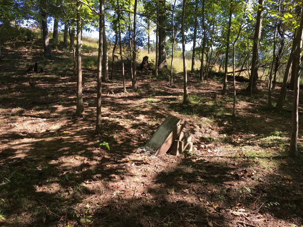
| Description | : | The Kyer Family Cemetery is located on the hill at the start of the ridge between Upper and Lower Two Runs off of Crooked Fork. It is currently unfenced and several of the homemade headstones are knocked down. It is in a cow pasture. |
frequently asked questions (FAQ):
-
Where is Kyer Cemetery?
Kyer Cemetery is located at Crooked Fork Rd Perkins, Gilmer County ,West Virginia ,USA.
-
Kyer Cemetery cemetery's updated grave count on graveviews.com?
0 memorials
-
Where are the coordinates of the Kyer Cemetery?
Latitude: 38.7861111
Longitude: -80.9169444
Nearby Cemetories:
1. Moore Cemetery
Normantown, Gilmer County, USA
Coordinate: 38.7986160, -80.8970590
2. Crooked Fork Baptist Church Cemetery
Perkins, Gilmer County, USA
Coordinate: 38.7714360, -80.8988930
3. Oak Grove Cemetery
Normantown, Gilmer County, USA
Coordinate: 38.8061420, -80.9267360
4. Frame Family Cemetery
Gilmer County, USA
Coordinate: 38.7864810, -80.8782790
5. Mowery-Deulley Cemetery
Gilmer County, USA
Coordinate: 38.7982070, -80.8814230
6. Albert VanHorn Cemetery
Orton, Gilmer County, USA
Coordinate: 38.8178020, -80.8983150
7. Mount Camel Baptist Church Cemetery
Gassaway, Braxton County, USA
Coordinate: 38.8174450, -80.8914080
8. Mount Carmel Cemetery
Normantown, Gilmer County, USA
Coordinate: 38.8174280, -80.8913720
9. Boggs Cemetery
Normantown, Gilmer County, USA
Coordinate: 38.8238160, -80.9127130
10. Rosedale Cemetery
Gilmer County, USA
Coordinate: 38.7544770, -80.9442990
11. Chestnut Lick Community Church Cemetery
Gilmer County, USA
Coordinate: 38.8223950, -80.9426220
12. Susan Stump Cemetery
Shock, Gilmer County, USA
Coordinate: 38.8012660, -80.9749330
13. Currycomb Cemetery
Braxton County, USA
Coordinate: 38.7919006, -80.8503036
14. Karickhoff Cemetery
Braxton, Braxton County, USA
Coordinate: 38.7922480, -80.8501500
15. Bourn Cemetery
Braxton County, USA
Coordinate: 38.7327995, -80.9293976
16. Upper Steer Run Baptist Church Cemetery
Gilmer County, USA
Coordinate: 38.8429370, -80.9227830
17. Mollohan Cemetery
Normantown, Gilmer County, USA
Coordinate: 38.8429600, -80.9262500
18. Michael Stump Cemetery-Steer Creek
Stumptown, Gilmer County, USA
Coordinate: 38.8273200, -80.9736800
19. Norman Cemetery
Normantown, Gilmer County, USA
Coordinate: 38.8236111, -80.8516666
20. Beall Cemetery
Normantown, Gilmer County, USA
Coordinate: 38.8461306, -80.8910306
21. Sumpter Cemetery
Normantown, Gilmer County, USA
Coordinate: 38.8472222, -80.8805556
22. Normantown Cemetery
Normantown, Gilmer County, USA
Coordinate: 38.8511040, -80.9403910
23. Whitesel Cemetery
Cedarville, Gilmer County, USA
Coordinate: 38.8048000, -80.8327000
24. Belknap Family-Bender Run Church Cemetery
Braxton County, USA
Coordinate: 38.7831630, -80.8286890