
| Memorials | : | 0 |
| Location | : | Le Grand-Luce, Departement de la Sarthe, France |
| Coordinate | : | 47.8642900, 0.4616300 |
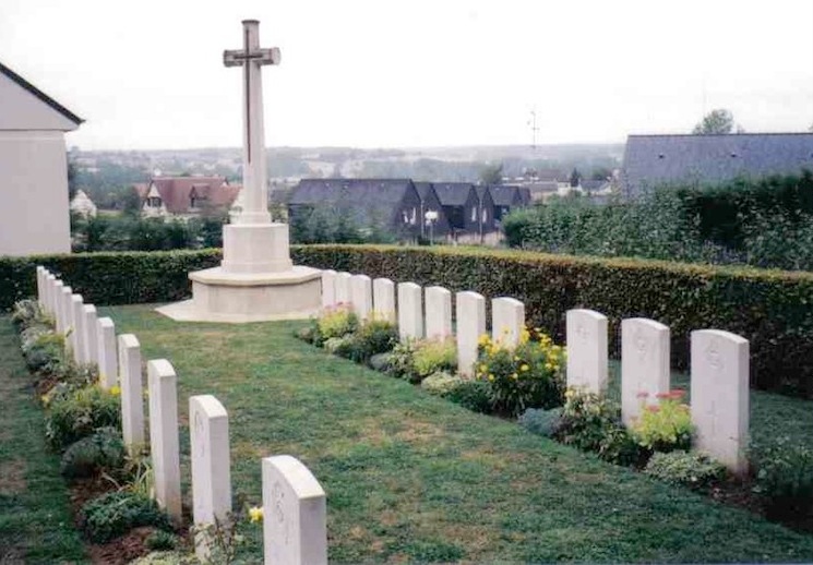
| Description | : | Le Grand-Lucé is about 27 kilometres south-east of Le Mans. Follow the D304 road to Le Grand-Lucé. Turn right at the entrance of the village and then right again to the top of a steep road and then left in front of the chateau wall. Le Grand-Lucé Cemetery stands on the left just after the Communal Cemetery. A Cross of Sacrifice is erected in the plot. There are 42 Commonwealth burials of World War II here, 4 of which are unidentified. |
frequently asked questions (FAQ):
-
Where is Le Grand-Luce War Cemetery?
Le Grand-Luce War Cemetery is located at Le Grand-Luce, Departement de la Sarthe ,Pays de la Loire ,France.
-
Le Grand-Luce War Cemetery cemetery's updated grave count on graveviews.com?
0 memorials
-
Where are the coordinates of the Le Grand-Luce War Cemetery?
Latitude: 47.8642900
Longitude: 0.4616300
Nearby Cemetories:
1. Chateau-du-Loir Communal Cemetery
Chateau-du-Loir, Departement de la Sarthe, France
Coordinate: 47.6955300, 0.4247800
2. Église Saint-Ouen-en-Belin
Saint-Ouen-en-Belin, Departement de la Sarthe, France
Coordinate: 47.8336000, 0.2114000
3. Champagne Communal Cemetery
Champagne, Departement de la Sarthe, France
Coordinate: 48.0233000, 0.3350100
4. Circuit de la Sarthe
Le Mans, Departement de la Sarthe, France
Coordinate: 47.9517340, 0.2078000
5. L'Abbaye de l'Epau
Yvre-l'Eveque, Departement de la Sarthe, France
Coordinate: 47.9911110, 0.2419440
6. Yvre l'Eveque Communal Cemetery
Yvre-l'Eveque, Departement de la Sarthe, France
Coordinate: 48.0119100, 0.2642400
7. Église de Notre Dame du Parc
Saint-Denis-d'Orques, Departement de la Sarthe, France
Coordinate: 48.0281940, 0.2868630
8. Souge-sur-Braye Communal Cemetery
Souge, Departement du Loir-et-Cher, France
Coordinate: 47.7701400, 0.7302300
9. Cimetière Saint-Pierre-de-Chevillé
Saint-Pierre-de-Cheville, Departement de la Sarthe, France
Coordinate: 47.6479690, 0.4383210
10. Collégiale de Bueil-en-Touraine
Bueil-en-Touraine, Departement d'Indre-et-Loire, France
Coordinate: 47.6455560, 0.5508330
11. Collégiale Saint-Pierre-la-Cour
Le Mans, Departement de la Sarthe, France
Coordinate: 48.0069440, 0.1972220
12. Cathédrale Saint Julien-Le Mans
Le Mans, Departement de la Sarthe, France
Coordinate: 48.0093510, 0.1987660
13. Le Mans West Cemetery
Le Mans, Departement de la Sarthe, France
Coordinate: 48.0210228, 0.1901290
14. La Bosse Communal Cemetery
La Bosse, Departement de la Sarthe, France
Coordinate: 48.1714400, 0.5271400
15. Saint Rimay Cemetery
Saint-Rimay, Departement du Loir-et-Cher, France
Coordinate: 47.7671450, 0.9147830
16. Cimetière de Beaumont-la Ronce
Beaumont-la-Ronce, Departement d'Indre-et-Loire, France
Coordinate: 47.5682270, 0.6691530
17. Thore Cemetery
Thore-la-Rochette, Departement du Loir-et-Cher, France
Coordinate: 47.7903454, 0.9685482
18. Villiers-sur-Loir Communal Cemetery
Villiers-sur-Loir, Departement du Loir-et-Cher, France
Coordinate: 47.8035800, 0.9910300
19. St Brice de Courcival Parish Cemetery
Courcival, Departement de la Sarthe, France
Coordinate: 48.2293900, 0.3961600
20. Malicorne-sur-Sarthe Cimetière Communal
Malicorne-sur-Sarthe, Departement de la Sarthe, France
Coordinate: 47.8128000, -0.0811300
21. Saint Aubin Abbey
Angers, Departement de Maine-et-Loire, France
Coordinate: 47.4683330, 0.5530560
22. La Fleche Communal Cemetery
La Fleche, Departement de la Sarthe, France
Coordinate: 47.6989200, -0.0849300
23. Chateau Renault Communal Cemetery
Chateau-Renault, Departement d'Indre-et-Loire, France
Coordinate: 47.5980800, 0.9118300
24. Vendome Town Cemetery
Vendome, Departement du Loir-et-Cher, France
Coordinate: 47.8052110, 1.0682970