
| Memorials | : | 11 |
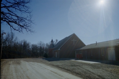
| Location | : | Bessville, Bollinger County, USA |
| Coordinate | : | 37.4537100, -90.0919700 |
frequently asked questions (FAQ):
-
Where is Liberty Congregational Methodist Church Cemetery?
Liberty Congregational Methodist Church Cemetery is located at Bessville, Bollinger County ,Missouri ,USA.
-
Liberty Congregational Methodist Church Cemetery cemetery's updated grave count on graveviews.com?
11 memorials
-
Where are the coordinates of the Liberty Congregational Methodist Church Cemetery?
Latitude: 37.4537100
Longitude: -90.0919700
Nearby Cemetories:
1. Pleasant Valley Cemetery
Gipsy, Bollinger County, USA
Coordinate: 37.4580800, -90.0801100
2. Old Concord Cemetery
Bollinger County, USA
Coordinate: 37.4658012, -90.1006012
3. Slinkard Cemetery
Patton, Bollinger County, USA
Coordinate: 37.4406013, -90.0777969
4. Mount Carmel Missionary Baptist Church Cemetery
Tallent, Bollinger County, USA
Coordinate: 37.4564438, -90.0537186
5. Hawn Cemetery
Bollinger County, USA
Coordinate: 37.4239006, -90.1063995
6. Pine Union Church Cemetery
Bollinger County, USA
Coordinate: 37.4693100, -90.1314600
7. Union Light Cemetery
Loyd, Bollinger County, USA
Coordinate: 37.4956131, -90.0978851
8. New Bethel Congregational Methodist Church Cemeter
Bollinger County, USA
Coordinate: 37.4151450, -90.0555070
9. Berry Cemetery
Bollinger County, USA
Coordinate: 37.4000015, -90.1128006
10. Hurricane Fork Cemetery
Hurricane, Bollinger County, USA
Coordinate: 37.4186668, -90.0178833
11. Old Union Methodist Church Cemetery
Bessville, Bollinger County, USA
Coordinate: 37.3844719, -90.0987778
12. Moores Cemetery
Bollinger County, USA
Coordinate: 37.3883018, -90.0522003
13. Pleasant Hill Cemetery
Bollinger County, USA
Coordinate: 37.5172005, -90.0449982
14. Rhodes Chapel Cemetery
Marquand, Madison County, USA
Coordinate: 37.4815331, -90.1804581
15. Whitener Cemetery
Marquand, Madison County, USA
Coordinate: 37.4089012, -90.1686020
16. Mouser Cemetery
Marquand, Madison County, USA
Coordinate: 37.4303017, -90.1825027
17. Patton Cemetery
Patton, Bollinger County, USA
Coordinate: 37.5022700, -90.0185200
18. Mungle Cemetery
Bollinger County, USA
Coordinate: 37.5131200, -90.0264900
19. McMahan Cemetery
Bessville, Bollinger County, USA
Coordinate: 37.3767014, -90.0597000
20. Dalton Cemetery
Bollinger County, USA
Coordinate: 37.4897003, -89.9969025
21. Plainview Cemetery
Hurricane, Bollinger County, USA
Coordinate: 37.3914452, -90.0123291
22. Lincoln Cemetery
Hurricane, Bollinger County, USA
Coordinate: 37.3955994, -90.0010986
23. Blaylock Cemetery
Madison County, USA
Coordinate: 37.3739014, -90.1524963
24. Rock Point Cemetery
Madison County, USA
Coordinate: 37.3738200, -90.1524760