
| Memorials | : | 0 |
| Location | : | Rose Creek, McNairy County, USA |
| Coordinate | : | 35.1832930, -88.7439180 |
| Description | : | From the intersection of Rose Creek Rd. & US-64 E, west of Selmer, travel southwest on Rose Creek Rd. for 2.3 mi.; turning northwest (right) onto Mt. Pleasant Rd., going 1.5 mi., passing the Mt Pleasant Ch. & Cem.; turning south (left) at a cattle guard, onto a field road (seems to connect eventually with the Hughey Talley Rd), going about 1/4 mi. to the cemetery, off to the left. According to Harold Cox, there are many unidentified graves here, most of which are marked with sand-stone and concrete blocks. |
frequently asked questions (FAQ):
-
Where is Lowrance Cemetery?
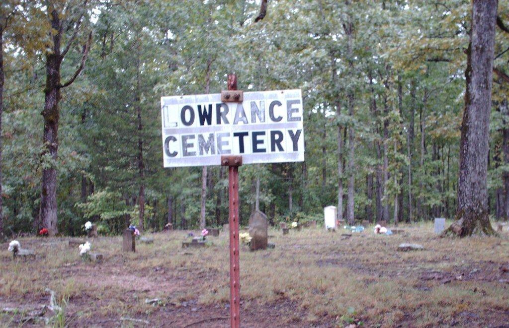
Lowrance Cemetery is located at 3841-3879 Mount Pleasant Road Rose Creek, McNairy County ,Tennessee ,USA.
-
Lowrance Cemetery cemetery's updated grave count on graveviews.com?
0 memorials
-
Where are the coordinates of the Lowrance Cemetery?
Latitude: 35.1832930
Longitude: -88.7439180
Nearby Cemetories:
1. Mount Pleasant Church Cemetery
Rose Creek, McNairy County, USA
Coordinate: 35.1839790, -88.7295350
2. McCalips Chapel Cemetery
McNairy County, USA
Coordinate: 35.1586510, -88.7573380
3. Rose Creek Village Cemetery
Selmer, McNairy County, USA
Coordinate: 35.1804070, -88.7074970
4. Hunters Chapel Cemetery
Selmer, McNairy County, USA
Coordinate: 35.1633060, -88.7110830
5. Chapel Hill Baptist Church Cemetery
McNairy County, USA
Coordinate: 35.1456090, -88.7599310
6. Ingle Cemetery
Bethel Springs, McNairy County, USA
Coordinate: 35.2257860, -88.7295090
7. Mount Gilead Cemetery
Rose Creek, McNairy County, USA
Coordinate: 35.2305610, -88.7466800
8. Wallace Cemetery
Selmer, McNairy County, USA
Coordinate: 35.1663889, -88.6836111
9. Lock Family Cemetery
Selmer, McNairy County, USA
Coordinate: 35.1313100, -88.7128930
10. Curtis Hill Church Cemetery
Bethel Springs, McNairy County, USA
Coordinate: 35.2257840, -88.6947630
11. Moores Schoolhouse Church Cemetery
Bethel Springs, McNairy County, USA
Coordinate: 35.2078018, -88.6766968
12. Hatchie Cemetery
Hornsby, Hardeman County, USA
Coordinate: 35.2026460, -88.8178200
13. Brint Family Cemetery
Hornsby, Hardeman County, USA
Coordinate: 35.1753570, -88.8217980
14. McIntire Cemetery
Bethel Springs, McNairy County, USA
Coordinate: 35.2160000, -88.6756000
15. Woodville Cemetery
Woodville, Chester County, USA
Coordinate: 35.2500000, -88.7630005
16. Center Ridge Church Cemetery
Bethel Springs, McNairy County, USA
Coordinate: 35.2499530, -88.7128610
17. Sulphur Springs United Methodist Church Cemetery
Selmer, McNairy County, USA
Coordinate: 35.1337900, -88.6791110
18. Gooch Cemetery
McNairy County, USA
Coordinate: 35.1086006, -88.7585983
19. Powell Chapel Cemetery
Middleton, Hardeman County, USA
Coordinate: 35.1302820, -88.8113800
20. Brints Chapel Community Cemetery
Middleton, Hardeman County, USA
Coordinate: 35.1635200, -88.8368500
21. Dillon Family Cemetery
Selmer, McNairy County, USA
Coordinate: 35.1184060, -88.6844460
22. Grantham Cemetery
Middleton, Hardeman County, USA
Coordinate: 35.1527300, -88.8388830
23. Eureka Cemetery
Pocahontas, Hardeman County, USA
Coordinate: 35.0994920, -88.7723770
24. Eureka Cemetery
McNairy County, USA
Coordinate: 35.0994240, -88.7724050