
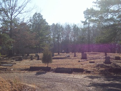
| Memorials | : | 1 |
| Location | : | Rose Creek, McNairy County, USA |
| Coordinate | : | 35.1839790, -88.7295350 |
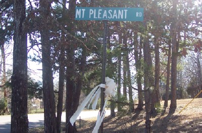
| Description | : | From the intersection of King Rd. & Hines Gin Rd., west of Selmer, travel northwest on King Rd. for 1.6 mi.; turning south, (left) onto Rose Creek Rd., going 150 ft.; turning northwest (right) onto Mt. Pleasant Rd., going 0.7 mi. to the circular driveway of the cemetery on the south (left), just past the old church building. |
frequently asked questions (FAQ):
-
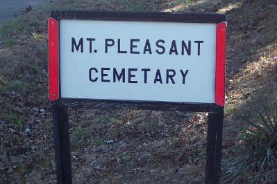
Where is Mount Pleasant Church Cemetery?
Mount Pleasant Church Cemetery is located at 1444 Mount Pleasant Road Rose Creek, McNairy County ,Tennessee , 38375USA.
-
Mount Pleasant Church Cemetery cemetery's updated grave count on graveviews.com?
1 memorials
-
Where are the coordinates of the Mount Pleasant Church Cemetery?
Latitude: 35.1839790
Longitude: -88.7295350
Nearby Cemetories:
1. Lowrance Cemetery
Rose Creek, McNairy County, USA
Coordinate: 35.1832930, -88.7439180
2. Rose Creek Village Cemetery
Selmer, McNairy County, USA
Coordinate: 35.1804070, -88.7074970
3. Hunters Chapel Cemetery
Selmer, McNairy County, USA
Coordinate: 35.1633060, -88.7110830
4. McCalips Chapel Cemetery
McNairy County, USA
Coordinate: 35.1586510, -88.7573380
5. Wallace Cemetery
Selmer, McNairy County, USA
Coordinate: 35.1663889, -88.6836111
6. Ingle Cemetery
Bethel Springs, McNairy County, USA
Coordinate: 35.2257860, -88.7295090
7. Chapel Hill Baptist Church Cemetery
McNairy County, USA
Coordinate: 35.1456090, -88.7599310
8. Mount Gilead Cemetery
Rose Creek, McNairy County, USA
Coordinate: 35.2305610, -88.7466800
9. Moores Schoolhouse Church Cemetery
Bethel Springs, McNairy County, USA
Coordinate: 35.2078018, -88.6766968
10. Curtis Hill Church Cemetery
Bethel Springs, McNairy County, USA
Coordinate: 35.2257840, -88.6947630
11. Lock Family Cemetery
Selmer, McNairy County, USA
Coordinate: 35.1313100, -88.7128930
12. McIntire Cemetery
Bethel Springs, McNairy County, USA
Coordinate: 35.2160000, -88.6756000
13. Sulphur Springs United Methodist Church Cemetery
Selmer, McNairy County, USA
Coordinate: 35.1337900, -88.6791110
14. Center Ridge Church Cemetery
Bethel Springs, McNairy County, USA
Coordinate: 35.2499530, -88.7128610
15. Woodville Cemetery
Woodville, Chester County, USA
Coordinate: 35.2500000, -88.7630005
16. Hatchie Cemetery
Hornsby, Hardeman County, USA
Coordinate: 35.2026460, -88.8178200
17. Dillon Family Cemetery
Selmer, McNairy County, USA
Coordinate: 35.1184060, -88.6844460
18. Brint Family Cemetery
Hornsby, Hardeman County, USA
Coordinate: 35.1753570, -88.8217980
19. Gooch Cemetery
McNairy County, USA
Coordinate: 35.1086006, -88.7585983
20. Buena Vista Church Cemetery
Bethel Springs, McNairy County, USA
Coordinate: 35.2394910, -88.6520210
21. Powell Chapel Cemetery
Middleton, Hardeman County, USA
Coordinate: 35.1302820, -88.8113800
22. Simpson-Wolfe Cemetery
Selmer, McNairy County, USA
Coordinate: 35.1644420, -88.6240660
23. Brints Chapel Community Cemetery
Middleton, Hardeman County, USA
Coordinate: 35.1635200, -88.8368500
24. Nethery Cemetery
Ramer, McNairy County, USA
Coordinate: 35.0978012, -88.6964035