
| Memorials | : | 0 |
| Location | : | Excello, Macon County, USA |
| Coordinate | : | 39.6084518, -92.4564667 |
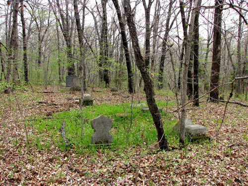
| Description | : | McCanne Burying Ground Cemetery is located on the north side of Karma Road (B 20). Directions: From Jacksonville, (Randolph Co) go north on Hwy 63. Turn right on Karma Rd. From the intersection of Hwy 63 and Karma Rd, the cemetery is about 7/8 of a mile on the north side of the road. The cemetery is on privately owned farmland, and the graves are not viewable from Karma Rd. The coordinates are 39.608450N and -92.456470W. Early Coulter Cemetery inscriptions state that the Coulter Cemetery was once known as the McCanne Burying Ground. However, there are... Read More |
frequently asked questions (FAQ):
-
Where is McCanne Burying Ground?
McCanne Burying Ground is located at Excello, Macon County ,Missouri ,USA.
-
McCanne Burying Ground cemetery's updated grave count on graveviews.com?
0 memorials
-
Where are the coordinates of the McCanne Burying Ground?
Latitude: 39.6084518
Longitude: -92.4564667
Nearby Cemetories:
1. Coulter Cemetery
Jacksonville, Randolph County, USA
Coordinate: 39.6062000, -92.4435900
2. Coulter Cemetery
Macon County, USA
Coordinate: 39.6238060, -92.4691772
3. Stevens-Coulter Family Cemetery
Macon County, USA
Coordinate: 39.6126850, -92.4840747
4. Mount Salem Cemetery
Excello, Macon County, USA
Coordinate: 39.6227600, -92.4864700
5. Old Jacksonville Cemetery
Jacksonville, Randolph County, USA
Coordinate: 39.5769600, -92.4670500
6. Missouri Veterans Cemetery at Jacksonville
Jacksonville, Randolph County, USA
Coordinate: 39.5817795, -92.4808426
7. Reynolds Cemetery
Jacksonville, Randolph County, USA
Coordinate: 39.5855700, -92.4982300
8. Lamb Cemetery
Excello, Macon County, USA
Coordinate: 39.6503460, -92.4443200
9. Butler-Thompson Cemetery
Macon County, USA
Coordinate: 39.6492100, -92.4812290
10. Davis Cemetery
Randolph County, USA
Coordinate: 39.5630240, -92.4691570
11. Waller Family Burial Ground
Excello, Macon County, USA
Coordinate: 39.6529490, -92.4265630
12. Eads Chapel Cemetery
Randolph County, USA
Coordinate: 39.5742580, -92.5052750
13. Ray Cemetery
Macon County, USA
Coordinate: 39.6332990, -92.3953370
14. Landram Cemetery
Cox, Macon County, USA
Coordinate: 39.6249230, -92.3885430
15. Friendship Baptist Church Cemetery
Macon, Macon County, USA
Coordinate: 39.6620070, -92.4198680
16. Gregory Cemetery
Randolph County, USA
Coordinate: 39.5640660, -92.5119030
17. Fairview Cemetery
Cox, Macon County, USA
Coordinate: 39.6371600, -92.3824800
18. Gilchrist Cemetery
Macon County, USA
Coordinate: 39.6450210, -92.5369770
19. Grand Prairie Cemetery
Cairo, Randolph County, USA
Coordinate: 39.5363998, -92.4539032
20. Chapel Hill Cemetery
Narrows Township, Macon County, USA
Coordinate: 39.6834700, -92.4571800
21. Gaunt Cemetery
Macon, Macon County, USA
Coordinate: 39.6841202, -92.4748306
22. Jones-Brock Cemetery
Cairo, Randolph County, USA
Coordinate: 39.5458370, -92.3983460
23. Ardmore Black Cemetery
Macon County, USA
Coordinate: 39.6456010, -92.5444840
24. Switzer Cemetery
Macon County, USA
Coordinate: 39.6116300, -92.3548440