
| Memorials | : | 0 |
| Location | : | Republic, Greene County, USA |
| Coordinate | : | 37.1425896, -93.3742294 |
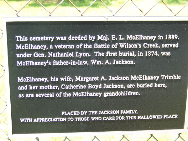
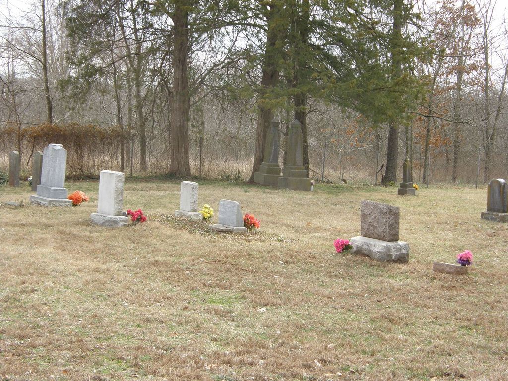
| Description | : | McElhaney Cemetery Section 7 township 28N Range 22W 2nd Campbell Township From Springfield, MO. South Campbell [US 160] and Republic Road [SH M], west for 4 miles to SH FF, north/right 1/2 mile to FR 168, west/left for 1/4 mile to just past Pleasant Springs Church. Then south 1/4 mile down farm lane on private property. This cemetery has chain link fencing, and is somewhat cared for. Some of the stones have toppled over. The obituary for E. L. McElhaney states he deeded the land for this cemetery in the fall of 1889, before he died in Jan. 1890, however, no... Read More |
frequently asked questions (FAQ):
-
Where is McElhaney Cemetery?
McElhaney Cemetery is located at Republic, Greene County ,Missouri ,USA.
-
McElhaney Cemetery cemetery's updated grave count on graveviews.com?
0 memorials
-
Where are the coordinates of the McElhaney Cemetery?
Latitude: 37.1425896
Longitude: -93.3742294


Nearby Cemetories:
1. Norman Cemetery
Battlefield, Greene County, USA
Coordinate: 37.1394420, -93.3649380
2. Hampton Cemetery
Springfield, Greene County, USA
Coordinate: 37.1568298, -93.3744202
3. Phillips Cemetery
Battlefield, Greene County, USA
Coordinate: 37.1281013, -93.3694000
4. Payne Family Cemeteru
Springfield, Greene County, USA
Coordinate: 37.1515046, -93.3550087
5. Payne Cemetery
Springfield, Greene County, USA
Coordinate: 37.1516113, -93.3547516
6. Russell and Ringenberg Cemetery
Springfield, Greene County, USA
Coordinate: 37.1695200, -93.3651580
7. Edgar Cemetery
Battlefield, Greene County, USA
Coordinate: 37.1157990, -93.4021988
8. Brookline Cemetery
Brookline, Greene County, USA
Coordinate: 37.1702995, -93.4141998
9. Julian-FulbrightOwen Family Cemetery
Battlefield, Greene County, USA
Coordinate: 37.1032791, -93.3523407
10. Rose Cemetery
Springfield, Greene County, USA
Coordinate: 37.1851470, -93.3462860
11. Gray-Campbell Cemetery
Springfield, Greene County, USA
Coordinate: 37.1729400, -93.3255300
12. McHaffie Cemetery
Springfield, Greene County, USA
Coordinate: 37.0971985, -93.3993988
13. Manley Cemetery
Republic, Greene County, USA
Coordinate: 37.0972746, -93.3996353
14. Glidewell Cemetery
Guin, Christian County, USA
Coordinate: 37.0924100, -93.3755000
15. Harrington Cemetery
Republic, Greene County, USA
Coordinate: 37.1260986, -93.4353027
16. Yarbrough Cemetery
Greene County, USA
Coordinate: 37.1314011, -93.3106003
17. Rountree Cemetery
Springfield, Greene County, USA
Coordinate: 37.1913532, -93.3367156
18. Patterson Cemetery
Springfield, Greene County, USA
Coordinate: 37.1044006, -93.3186035
19. Redeemer Lutheran Church Columbarium
Springfield, Greene County, USA
Coordinate: 37.1625700, -93.3012600
20. Manley Cemetery
Nixa, Christian County, USA
Coordinate: 37.0802994, -93.3731003
21. Hale Cemetery
Christian County, USA
Coordinate: 37.0800018, -93.4047012
22. Griffin Cemetery
Nixa, Christian County, USA
Coordinate: 37.0749250, -93.3716139
23. Carmelite Monastery Cemetery
Springfield, Greene County, USA
Coordinate: 37.1396103, -93.2893677
24. Saint Marys Cemetery
Springfield, Greene County, USA
Coordinate: 37.2038994, -93.3249969