
| Memorials | : | 0 |
| Location | : | Lagunitas, Marin County, USA |
| Coordinate | : | 38.0272580, -122.7346590 |
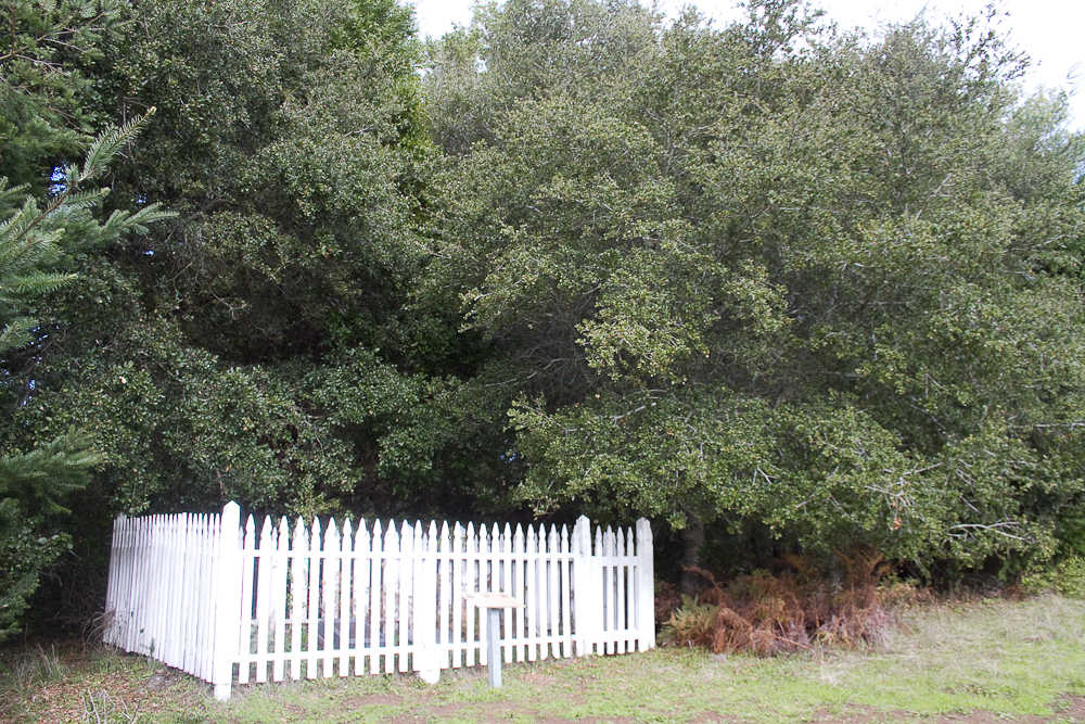
| Description | : | Samuel Penfield Taylor and Sarah Taylor Marin County Pioneers This quaint burial site consists of two grave markers surrounded by a white picket fence. It is in a lovely spot overlooking what used to be Taylorville and is now S. P. Taylor State Park, named for Marin County pioneer, Samuel Penfield Taylor. The Taylor's are interred on a little knoll, not far from the summit of Mount Barnabe. Mount Barnabe was named for Samuel Penfield Taylor's retired army mule. |
frequently asked questions (FAQ):
-
Where is Taylor Cemetery?
Taylor Cemetery is located at Lagunitas, Marin County ,California ,USA.
-
Taylor Cemetery cemetery's updated grave count on graveviews.com?
0 memorials
-
Where are the coordinates of the Taylor Cemetery?
Latitude: 38.0272580
Longitude: -122.7346590
Nearby Cemetories:
1. Olema Cemetery
Olema, Marin County, USA
Coordinate: 38.0313988, -122.7789001
2. Bolinas Cemetery
Bolinas, Marin County, USA
Coordinate: 37.9212600, -122.6938900
3. Saint Mary Magdalene Catholic Church Cemetery
Bolinas, Marin County, USA
Coordinate: 37.9212570, -122.6938858
4. Saint Columbas Church Cemetery
Inverness, Marin County, USA
Coordinate: 38.0998250, -122.8576210
5. Marin County Farm Cemetery
Marin County, USA
Coordinate: 38.0285500, -122.5652530
6. Pioneer Memorial Cemetery
Novato, Marin County, USA
Coordinate: 38.1132532, -122.5902599
7. First Presbyterian Church Memorial Garden
San Anselmo, Marin County, USA
Coordinate: 37.9703310, -122.5667860
8. Montgomery Memorial Chapel Crypt
San Anselmo, Marin County, USA
Coordinate: 37.9687940, -122.5638630
9. Mount Tamalpais Cemetery
San Rafael, Marin County, USA
Coordinate: 37.9861984, -122.5544891
10. Mount Olivet Catholic Cemetery
San Rafael, Marin County, USA
Coordinate: 38.0024986, -122.5397034
11. Saint Vincents Orphanage Cemetery
San Rafael, Marin County, USA
Coordinate: 38.0355800, -122.5334550
12. Historic Life-Saving Service and G Ranch Cemetery
Point Reyes Station, Marin County, USA
Coordinate: 38.0933000, -122.9311300
13. Miwok Cemetery
Reynolds, Marin County, USA
Coordinate: 38.1491420, -122.8852400
14. Mission San Rafael Arcangel Cemetery
San Rafael, Marin County, USA
Coordinate: 37.9744330, -122.5280570
15. Valley Memorial Park
Novato, Marin County, USA
Coordinate: 38.1204300, -122.5436300
16. Druid Heights Burial Site
Mill Valley, Marin County, USA
Coordinate: 37.8892100, -122.5647100
17. San Quentin Prison Cemetery
San Rafael, Marin County, USA
Coordinate: 37.9436480, -122.4883760
18. Oak Hill Cemetery
Petaluma, Sonoma County, USA
Coordinate: 38.2365130, -122.6509010
19. Fernwood Cemetery
Mill Valley, Marin County, USA
Coordinate: 37.8767014, -122.5231018
20. Calvary Catholic Cemetery
Petaluma, Sonoma County, USA
Coordinate: 38.2449000, -122.6493400
21. B'nai Israel Cemetery
Petaluma, Sonoma County, USA
Coordinate: 38.2454700, -122.6490000
22. My Pets Cemetery
Petaluma, Sonoma County, USA
Coordinate: 38.2472000, -122.6506000
23. Cypress Hill Memorial Park
Petaluma, Sonoma County, USA
Coordinate: 38.2472000, -122.6505966
24. Two Rock Presbyterian Church Cemetery
Two Rock, Sonoma County, USA
Coordinate: 38.2570000, -122.7795029