
| Memorials | : | 2 |
| Location | : | Colony, Washita County, USA |
| Coordinate | : | 35.4641991, -98.7285995 |
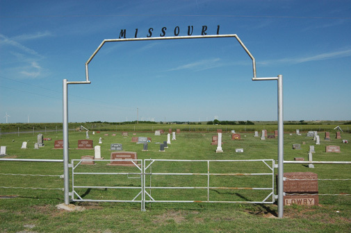
| Description | : | From Colony, Ok, 3 miles west, then 8 miles north on Hwy 54. Located in Texas Township; Legal description: NW ¼ Section 6, Township 11 N, Range 14 W. This cemetery was used by the Zion Chapel Church of Christ and the Missouri Rural School was located nearby. The land was homesteaded by Robert Lowry, who sold the land to Peter Sawatzky on February 2, 1931 except for 1 acre in the NW corner and there is no deed to the cemetery. Caretaker: Tim Lowry |
frequently asked questions (FAQ):
-
Where is Missouri Cemetery?
Missouri Cemetery is located at Colony, Washita County ,Oklahoma ,USA.
-
Missouri Cemetery cemetery's updated grave count on graveviews.com?
1 memorials
-
Where are the coordinates of the Missouri Cemetery?
Latitude: 35.4641991
Longitude: -98.7285995
Nearby Cemetories:
1. Bethel Krimmer Mennonite Cemetery
Weatherford, Custer County, USA
Coordinate: 35.4782982, -98.7546997
2. Zion German Congregational Church Cemetery
Corn, Washita County, USA
Coordinate: 35.4506454, -98.7648468
3. Bethany Cemetery
Colony, Washita County, USA
Coordinate: 35.4425011, -98.6755981
4. High Point Cemetery
Colony, Washita County, USA
Coordinate: 35.4207993, -98.6774979
5. South Cedar Cemetery
Custer County, USA
Coordinate: 35.4942017, -98.7994003
6. Greenwood Cemetery
Weatherford, Custer County, USA
Coordinate: 35.5355988, -98.7192001
7. Plainview Cemetery
Colony, Washita County, USA
Coordinate: 35.4568939, -98.6394577
8. Korn Catholic Cemetery
Corn, Washita County, USA
Coordinate: 35.4061203, -98.8010788
9. Bergthal Cemetery
Corn, Washita County, USA
Coordinate: 35.4198303, -98.8172073
10. Newton Cemetery
Custer County, USA
Coordinate: 35.5517700, -98.7647400
11. Mennonite Brethren Cemetery
Corn, Washita County, USA
Coordinate: 35.3717003, -98.7825012
12. Redbird Wolf Chief Indian Gravesite
Corn, Washita County, USA
Coordinate: 35.4052811, -98.8435669
13. Rockwell Cemetery
Weatherford, Custer County, USA
Coordinate: 35.5806007, -98.6849976
14. Indian Cemetery
Colony, Washita County, USA
Coordinate: 35.3450584, -98.6700134
15. Chapel Hill Cemetery
Clinton, Custer County, USA
Coordinate: 35.4934400, -98.8852100
16. Pleasant View Cemetery
Corn, Washita County, USA
Coordinate: 35.3347015, -98.7561035
17. Colony Indian Cemetery
Colony, Washita County, USA
Coordinate: 35.3410988, -98.6585999
18. Poage Cemetery
Caddo County, USA
Coordinate: 35.3717003, -98.6061020
19. Red Rock Cemetery
Clinton, Custer County, USA
Coordinate: 35.5380096, -98.8786774
20. Howling Walks Indian Cemetery
Bessie, Washita County, USA
Coordinate: 35.4510231, -98.9205551
21. Summit Cemetery
Custer County, USA
Coordinate: 35.6016998, -98.8257980
22. Little Sioux Indian Cemetery
Clinton, Custer County, USA
Coordinate: 35.4867400, -98.9229400
23. Shelley Cemetery
Corn, Washita County, USA
Coordinate: 35.3497009, -98.8703003
24. Holy Angeles Catholic Cemetery
Blaine County, USA
Coordinate: 35.5728912, -98.5791702