
| Memorials | : | 2 |
| Location | : | Corn, Washita County, USA |
| Coordinate | : | 35.4506454, -98.7648468 |
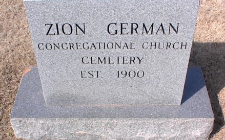
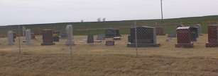
| Description | : | Located in Union Township; Legal description: SW ¼ Section 2, Township 11 N, Range 15 W. From Corn, Ok, 5 miles north, then 1 mile east. Heinrich and Katie Kissler deeded the land to the Zion German Church Trustees, January 16, 1916. Caretaker: Zane Bergen |
frequently asked questions (FAQ):
-
Where is Zion German Congregational Church Cemetery?
Zion German Congregational Church Cemetery is located at Corn, Washita County ,Oklahoma ,USA.
-
Zion German Congregational Church Cemetery cemetery's updated grave count on graveviews.com?
2 memorials
-
Where are the coordinates of the Zion German Congregational Church Cemetery?
Latitude: 35.4506454
Longitude: -98.7648468
Nearby Cemetories:
1. Bethel Krimmer Mennonite Cemetery
Weatherford, Custer County, USA
Coordinate: 35.4782982, -98.7546997
2. Missouri Cemetery
Colony, Washita County, USA
Coordinate: 35.4641991, -98.7285995
3. South Cedar Cemetery
Custer County, USA
Coordinate: 35.4942017, -98.7994003
4. Bergthal Cemetery
Corn, Washita County, USA
Coordinate: 35.4198303, -98.8172073
5. Korn Catholic Cemetery
Corn, Washita County, USA
Coordinate: 35.4061203, -98.8010788
6. Bethany Cemetery
Colony, Washita County, USA
Coordinate: 35.4425011, -98.6755981
7. High Point Cemetery
Colony, Washita County, USA
Coordinate: 35.4207993, -98.6774979
8. Redbird Wolf Chief Indian Gravesite
Corn, Washita County, USA
Coordinate: 35.4052811, -98.8435669
9. Mennonite Brethren Cemetery
Corn, Washita County, USA
Coordinate: 35.3717003, -98.7825012
10. Greenwood Cemetery
Weatherford, Custer County, USA
Coordinate: 35.5355988, -98.7192001
11. Newton Cemetery
Custer County, USA
Coordinate: 35.5517700, -98.7647400
12. Plainview Cemetery
Colony, Washita County, USA
Coordinate: 35.4568939, -98.6394577
13. Chapel Hill Cemetery
Clinton, Custer County, USA
Coordinate: 35.4934400, -98.8852100
14. Pleasant View Cemetery
Corn, Washita County, USA
Coordinate: 35.3347015, -98.7561035
15. Howling Walks Indian Cemetery
Bessie, Washita County, USA
Coordinate: 35.4510231, -98.9205551
16. Red Rock Cemetery
Clinton, Custer County, USA
Coordinate: 35.5380096, -98.8786774
17. Indian Cemetery
Colony, Washita County, USA
Coordinate: 35.3450584, -98.6700134
18. Shelley Cemetery
Corn, Washita County, USA
Coordinate: 35.3497009, -98.8703003
19. Little Sioux Indian Cemetery
Clinton, Custer County, USA
Coordinate: 35.4867400, -98.9229400
20. Colony Indian Cemetery
Colony, Washita County, USA
Coordinate: 35.3410988, -98.6585999
21. Rockwell Cemetery
Weatherford, Custer County, USA
Coordinate: 35.5806007, -98.6849976
22. Poage Cemetery
Caddo County, USA
Coordinate: 35.3717003, -98.6061020
23. Clinton Indian Cemetery
Custer County, USA
Coordinate: 35.5223200, -98.9333800
24. Herold Mennonite Church Cemetery
Bessie, Washita County, USA
Coordinate: 35.3596497, -98.9226608