
| Memorials | : | 0 |
| Location | : | Tosside, Ribble Valley Borough, England |
| Coordinate | : | 53.9982500, -2.3578200 |
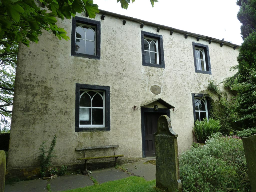
| Description | : | The chapel building dates from 1812. |
frequently asked questions (FAQ):
-
Where is Mount Sion Independent Chapelyard?
Mount Sion Independent Chapelyard is located at Sandy Syke Tosside, Ribble Valley Borough ,Lancashire , BD23 4SQEngland.
-
Mount Sion Independent Chapelyard cemetery's updated grave count on graveviews.com?
0 memorials
-
Where are the coordinates of the Mount Sion Independent Chapelyard?
Latitude: 53.9982500
Longitude: -2.3578200
Nearby Cemetories:
1. St Bartholomew Churchyard
Tosside, Ribble Valley Borough, England
Coordinate: 54.0002500, -2.3536700
2. St James Churchyard
Tosside, Ribble Valley Borough, England
Coordinate: 53.9940290, -2.4029690
3. Brocklands Woodland Burial Site
Rathmell, Craven District, England
Coordinate: 54.0275720, -2.2998880
4. Holy Trinity Churchyard
Rathmell, Craven District, England
Coordinate: 54.0351000, -2.3002300
5. Holden Chapel
Bolton-by-Bowland, Ribble Valley Borough, England
Coordinate: 53.9420850, -2.3500060
6. St Andrew Churchyard
Slaidburn, Ribble Valley Borough, England
Coordinate: 53.9641600, -2.4437090
7. St Peter and St Paul Churchyard
Bolton-by-Bowland, Ribble Valley Borough, England
Coordinate: 53.9399800, -2.3270300
8. Long Preston Baptist Chapel
Long Preston, Craven District, England
Coordinate: 54.0204249, -2.2560031
9. St Mary the Virgin Churchyard
Long Preston, Craven District, England
Coordinate: 54.0183790, -2.2497690
10. St. Aidan's Churchyard
Hellifield, Craven District, England
Coordinate: 54.0042070, -2.2201370
11. St Alkelda Churchyard
Giggleswick, Craven District, England
Coordinate: 54.0721700, -2.2894600
12. Friends Burial Ground
Settle, Craven District, England
Coordinate: 54.0685370, -2.2791100
13. Zion Congregational Chapelyard
Settle, Craven District, England
Coordinate: 54.0672490, -2.2747040
14. St. Mary the Virgin Churchyard
Gisburn, Ribble Valley Borough, England
Coordinate: 53.9356080, -2.2605210
15. Sawley Abbey
Sawley, Ribble Valley Borough, England
Coordinate: 53.9131920, -2.3417080
16. Holy Ascension Churchyard
Settle, Craven District, England
Coordinate: 54.0704320, -2.2775390
17. Grindleton Methodist Cemetery
Grindleton, Ribble Valley Borough, England
Coordinate: 53.9080420, -2.3684420
18. St Ambrose Churchyard
Grindleton, Ribble Valley Borough, England
Coordinate: 53.9061710, -2.3633270
19. St John the Evangelist Churchyard
Langcliffe, Craven District, England
Coordinate: 54.0807400, -2.2721000
20. Salem Congregational Chapel Martin Top
Rimington, Ribble Valley Borough, England
Coordinate: 53.9072484, -2.2740463
21. St. Matthew's Churchyard
Keasden, Craven District, England
Coordinate: 54.0945680, -2.4245830
22. Christ Churchyard
Chatburn, Ribble Valley Borough, England
Coordinate: 53.8940690, -2.3515030
23. St. Leonard's Churchyard
Downham, Ribble Valley Borough, England
Coordinate: 53.8944340, -2.3294250
24. Saint Michael's Church
Bracewell, Pendle Borough, England
Coordinate: 53.9322400, -2.2099730