
| Memorials | : | 4 |
| Location | : | Cliffs City, Kent County, USA |
| Coordinate | : | 39.1201105, -76.1430046 |
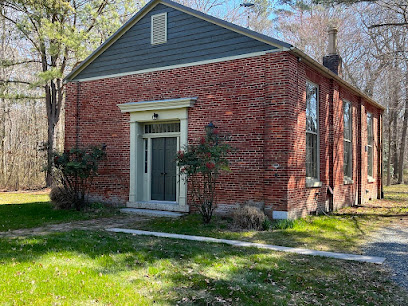
| Description | : | According to the Maryland State Archives, Mowbray Chapel was a Methodist Episcopal church that was once the center of social and religious life for the community of Cliffs. The Greek Revival church is described as being in ruinous condition, and abandoned. |
frequently asked questions (FAQ):
-
Where is Mowbray Chapel?
Mowbray Chapel is located at Quaker Neck Road Cliffs City, Kent County ,Maryland ,USA.
-
Mowbray Chapel cemetery's updated grave count on graveviews.com?
0 memorials
-
Where are the coordinates of the Mowbray Chapel?
Latitude: 39.1201105
Longitude: -76.1430046
Nearby Cemetories:
1. Comegys Bight Cemetery
Chestertown, Kent County, USA
Coordinate: 39.1204033, -76.1325912
2. Trew Family Cemetery
Chestertown, Kent County, USA
Coordinate: 39.1327553, -76.1409607
3. Conquest Farm Cemetery
Queen Anne's County, USA
Coordinate: 39.0953200, -76.1246300
4. Kelsey Methodist Protestant Chapel Cemetery
Fairlee, Kent County, USA
Coordinate: 39.1494510, -76.1640940
5. Ashley Burial Ground
Rock Hall, Kent County, USA
Coordinate: 39.1107020, -76.1942100
6. Ashley Cemetery
Rock Hall, Kent County, USA
Coordinate: 39.1107030, -76.1942110
7. Hadaway Chapel Cemetery
Kent County, USA
Coordinate: 39.1591988, -76.1607971
8. Piney Neck Cemetery
Rock Hall, Kent County, USA
Coordinate: 39.1206660, -76.1966180
9. Bond Chapel Cemetery
Kent County, USA
Coordinate: 39.1585999, -76.1136017
10. Emmanuel United Methodist Church Cemetery
Pomona, Kent County, USA
Coordinate: 39.1623700, -76.1029500
11. Mount Zion Cemetery
Queen Anne's County, USA
Coordinate: 39.0971985, -76.0736008
12. Holy Trinity AME Church Cemetery
Rock Hall, Kent County, USA
Coordinate: 39.1519700, -76.2067600
13. Burrisville U M Church Cemetery
Burrisville, Queen Anne's County, USA
Coordinate: 39.0968285, -76.0685196
14. Wesley Chapel Cemetery
Rock Hall, Kent County, USA
Coordinate: 39.1450005, -76.2181015
15. Aaron's Chapel Church Cemetery
Kent County, USA
Coordinate: 39.1350600, -76.2235650
16. Hynson Chapel Cemetery
Chestertown, Kent County, USA
Coordinate: 39.1891030, -76.1570530
17. Saint Johns Cemetery
Rock Hall, Kent County, USA
Coordinate: 39.1330986, -76.2319031
18. Saint Paul's Kent Churchyard
Chestertown, Kent County, USA
Coordinate: 39.1871740, -76.1794370
19. Jane's Cemetery
Chestertown, Kent County, USA
Coordinate: 39.1869020, -76.0743800
20. Trumpington Farm Cemetery
Rock Hall, Kent County, USA
Coordinate: 39.0657400, -76.2286860
21. Noel Cemetery
Centreville, Queen Anne's County, USA
Coordinate: 39.0492066, -76.0707207
22. Salem Methodist Episcopal Church Cemetery
Centreville, Queen Anne's County, USA
Coordinate: 39.1086370, -76.0259320
23. Melfield Farm Cemetery
Centreville, Queen Anne's County, USA
Coordinate: 39.0287850, -76.1655810
24. Hermitage Tilghman Family Burial Grounds
Centreville, Queen Anne's County, USA
Coordinate: 39.0291990, -76.1687750