
| Memorials | : | 0 |
| Location | : | Hayesville, Clay County, USA |
| Coordinate | : | 35.0023600, -83.8072400 |
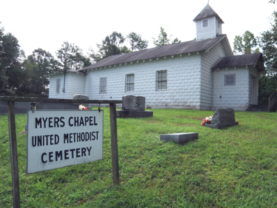
| Description | : | The Myers Chapel Church is a former United Methodist Congregation of the Smokey Mountain District of the Western North Carolina Conference. The congregation was disbanded in the 1980's. The building has since been used by various other denominations. The property is still held in trust by the United Methodist Church. The cemetery completely surrounds the church building on three sides. The property is land locked with Lake Chatuge on three sides of the cemetery and a road on the fourth. The cemetery is approximately three miles south of Hwy 64 and the town of Hayesville. |
frequently asked questions (FAQ):
-
Where is Myers Chapel United Methodist Cemetery?
Myers Chapel United Methodist Cemetery is located at Myers Chapel Rd Hayesville, Clay County ,North Carolina ,USA.
-
Myers Chapel United Methodist Cemetery cemetery's updated grave count on graveviews.com?
0 memorials
-
Where are the coordinates of the Myers Chapel United Methodist Cemetery?
Latitude: 35.0023600
Longitude: -83.8072400

Nearby Cemetories:
1. McClure Cemetery
Clay County, USA
Coordinate: 35.0083008, -83.7988968
2. Pine Grove Baptist Church Cemetery
Hayesville, Clay County, USA
Coordinate: 35.0165140, -83.8214940
3. Pilgrim Baptist Church Cemetery
Hayesville, Clay County, USA
Coordinate: 34.9911600, -83.8286900
4. Barnard Cemetery
Hayesville, Clay County, USA
Coordinate: 35.0236015, -83.7941971
5. Mountain Grace Baptist Church Cemetery
Hayesville, Clay County, USA
Coordinate: 34.9896120, -83.8373240
6. Episcopal Church of the Good Shepherd
Hayesville, Clay County, USA
Coordinate: 35.0340233, -83.7982178
7. Herbert Hills Cemetery
Hayesville, Clay County, USA
Coordinate: 35.0352450, -83.7990660
8. First United Methodist Church Cemetery
Hayesville, Clay County, USA
Coordinate: 35.0364800, -83.8185920
9. Good Shepherd Memorial Gardens
Hayesville, Clay County, USA
Coordinate: 35.0375320, -83.8017080
10. Oak Forest Cemetery
Hayesville, Clay County, USA
Coordinate: 35.0369500, -83.7934800
11. Hayesville Baptist-Presbyterian Cemetery
Hayesville, Clay County, USA
Coordinate: 35.0377490, -83.8199330
12. Philadelphia Baptist Church Cemetery
Hayesville, Clay County, USA
Coordinate: 35.0004500, -83.7616200
13. Rogers Cemetery
Hayesville, Clay County, USA
Coordinate: 35.0393830, -83.8200920
14. Old Ledford Chapel Cemetery
Hayesville, Clay County, USA
Coordinate: 34.9978371, -83.7596817
15. Shady Grove Missionary Baptist Church Cemetery
Hayesville, Clay County, USA
Coordinate: 35.0126240, -83.8646970
16. Ledford Chapel Methodist Cemetery
Hayesville, Clay County, USA
Coordinate: 35.0306015, -83.7572021
17. Ledford Family Cemetery
Hayesville, Clay County, USA
Coordinate: 35.0307230, -83.7572210
18. Mount Pisgah Baptist Church Cemetery
Hayesville, Clay County, USA
Coordinate: 34.9981260, -83.8813510
19. Meadow Grove Baptist Cemetery
Hayesville, Clay County, USA
Coordinate: 35.0655760, -83.8150200
20. Shiloh Baptist Church Cemetery
Hayesville, Clay County, USA
Coordinate: 35.0664450, -83.7932750
21. New Hope Baptist Church Cemetery
Hayesville, Clay County, USA
Coordinate: 35.0370950, -83.8766620
22. Union Hill Cemetery
Hayesville, Clay County, USA
Coordinate: 35.0342370, -83.7314150
23. Mount Pleasant Cemetery
Hayesville, Clay County, USA
Coordinate: 35.0339500, -83.7290640
24. Grace Baptist Church Cemetery
Hayesville, Clay County, USA
Coordinate: 35.0368000, -83.8896000