
| Memorials | : | 0 |
| Location | : | Hoar Cross, East Staffordshire Borough, England |
| Coordinate | : | 52.8083859, -1.7811304 |
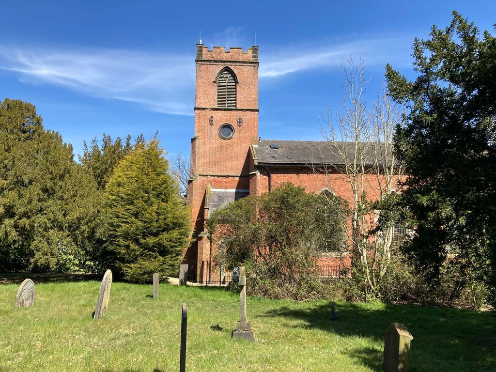
| Description | : | Christchurch, or Christchurch-in-Needwood was erected in 1809, to serve the disafforested portion of Needwood Forest, following its enclosure in 1804. The church itself has been closed for several years, and is now a private dwelling, but the graveyard is still consecrated, and remains open. |
frequently asked questions (FAQ):
-
Where is Newchurch, Christchurch-in-Needwood?
Newchurch, Christchurch-in-Needwood is located at Hoar Cross, East Staffordshire Borough ,Staffordshire ,England.
-
Newchurch, Christchurch-in-Needwood cemetery's updated grave count on graveviews.com?
0 memorials
-
Where are the coordinates of the Newchurch, Christchurch-in-Needwood?
Latitude: 52.8083859
Longitude: -1.7811304
Nearby Cemetories:
1. All Saints Churchyard
Newborough, East Staffordshire Borough, England
Coordinate: 52.8259013, -1.8003185
2. The Holy Angels Churchyard
Hoar Cross, East Staffordshire Borough, England
Coordinate: 52.8047974, -1.8161691
3. Catholic Church of Saint Francis of Sales
Yoxall, East Staffordshire Borough, England
Coordinate: 52.7844140, -1.7909000
4. All Saints Churchyard
Rangemore, East Staffordshire Borough, England
Coordinate: 52.8040800, -1.7337000
5. St. Peter's Churchyard
Yoxall, East Staffordshire Borough, England
Coordinate: 52.7687960, -1.7915250
6. St. Mary's Churchyard, Dunstall
Tatenhill, East Staffordshire Borough, England
Coordinate: 52.7809957, -1.7236464
7. St Werburgh's Church
Hanbury, East Staffordshire Borough, England
Coordinate: 52.8485000, -1.7478000
8. Holy Trinity Churchyard
Anslow, East Staffordshire Borough, England
Coordinate: 52.8216926, -1.7079807
9. RAF Fauld
Hanbury, East Staffordshire Borough, England
Coordinate: 52.8474200, -1.7303500
10. St. Michael and All Angels Churchyard
Tatenhill, East Staffordshire Borough, England
Coordinate: 52.7958170, -1.6968150
11. St. Michael & All Angels Churchyard
Hamstall Ridware, Lichfield District, England
Coordinate: 52.7716100, -1.8447300
12. St. James' Churchyard
Barton-under-Needwood, East Staffordshire Borough, England
Coordinate: 52.7641321, -1.7228176
13. St. Nicholas Churchyard
Abbots Bromley, East Staffordshire Borough, England
Coordinate: 52.8184560, -1.8837460
14. St Peter's Churchyard
Marchington, East Staffordshire Borough, England
Coordinate: 52.8738278, -1.7967917
15. St Leonard's Church
Wychnor, East Staffordshire Borough, England
Coordinate: 52.7420071, -1.7394617
16. Saint Saviour's Cemetery
Burton upon Trent, East Staffordshire Borough, England
Coordinate: 52.7892907, -1.6668628
17. St. Paul's Churchyard Extension
Scropton, South Derbyshire District, England
Coordinate: 52.8687230, -1.7133750
18. All Saints Churchyard
Alrewas, Lichfield District, England
Coordinate: 52.7347941, -1.7530332
19. Priory Church of St. Mary the Virgin
Tutbury, East Staffordshire Borough, England
Coordinate: 52.8590900, -1.6877900
20. St Laurence Churchyard
Walton-on-Trent, South Derbyshire District, England
Coordinate: 52.7613386, -1.6819775
21. All Saints Churchyard
Sudbury, Derbyshire Dales District, England
Coordinate: 52.8867660, -1.7667510
22. Rolleston Cemetery
Rolleston-on-Dove, East Staffordshire Borough, England
Coordinate: 52.8483757, -1.6643849
23. Saint John the Divine Churchyard
Horninglow, East Staffordshire Borough, England
Coordinate: 52.8237520, -1.6426170
24. National Memorial Arboretum
Alrewas, Lichfield District, England
Coordinate: 52.7274040, -1.7324890