| Memorials | : | 4 |
| Location | : | Martins Ferry, Belmont County, USA |
| Coordinate | : | 40.1325000, -80.7277780 |
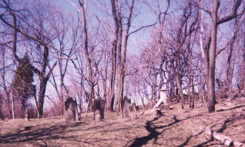
| Description | : | Thanks to a correction from Terry Magyar, this map is not correct. It is a copy of an old map found in a book, but the Muskingum River is not in that area of Ohio. This farm is just off Nixon Run Road, highway 16, in Martins Ferry area of Belmont Co., OH. This is a very small cemetery in poor condition. It’s on private property and there is no public access. |
frequently asked questions (FAQ):
-
Where is Nixon Farm Cemetery?
Nixon Farm Cemetery is located at Pease Twp. Martins Ferry, Belmont County ,Ohio ,USA.
-
Nixon Farm Cemetery cemetery's updated grave count on graveviews.com?
4 memorials
-
Where are the coordinates of the Nixon Farm Cemetery?
Latitude: 40.1325000
Longitude: -80.7277780
Nearby Cemetories:
1. Cochran Family Cemetery
Martins Ferry, Belmont County, USA
Coordinate: 40.1361110, -80.7230570
2. Henschel Cemetery
Pease Township, Belmont County, USA
Coordinate: 40.1197200, -80.7177840
3. Scotch Ridge Cemetery
Martins Ferry, Belmont County, USA
Coordinate: 40.1303490, -80.7606390
4. Upland Heights Cemetery
Warren Township, Jefferson County, USA
Coordinate: 40.1608009, -80.7285995
5. West Cemetery
Upland Heights, Jefferson County, USA
Coordinate: 40.1606241, -80.7343555
6. Riley Hill Road Cemetery
Clearview, Ohio County, USA
Coordinate: 40.1456299, -80.6941910
7. Riverview Cemetery
Martins Ferry, Belmont County, USA
Coordinate: 40.1032000, -80.7207600
8. Oaklawn Memorial Park
Clearview, Ohio County, USA
Coordinate: 40.1469002, -80.6931000
9. Walnut Grove Cemetery
Martins Ferry, Belmont County, USA
Coordinate: 40.0999985, -80.7181015
10. King Family Cemetery
Rayland, Jefferson County, USA
Coordinate: 40.1689423, -80.7109297
11. Saint Mary's Cemetery
Martins Ferry, Belmont County, USA
Coordinate: 40.0931015, -80.7446976
12. Wilson Cemetery
Clearview, Ohio County, USA
Coordinate: 40.1608009, -80.6813965
13. Weeks Cemetery
Bridgeport, Belmont County, USA
Coordinate: 40.0928001, -80.7605972
14. First Concord Cemetery
Colerain, Belmont County, USA
Coordinate: 40.1238880, -80.7888880
15. Mound Cemetery
Tiltonsville, Jefferson County, USA
Coordinate: 40.1744003, -80.6949997
16. Gregg Cemetery
Greggsville, Ohio County, USA
Coordinate: 40.0942001, -80.6881027
17. Lawrencefield Parish Church Cemetery
Ohio County, USA
Coordinate: 40.1281310, -80.6615600
18. Mount Wood Cemetery
Wheeling, Ohio County, USA
Coordinate: 40.0814018, -80.7225037
19. Concord Quaker Cemetery
Colerain Township, Belmont County, USA
Coordinate: 40.1244011, -80.7947006
20. Oak Grove Cemetery
Mount Pleasant, Jefferson County, USA
Coordinate: 40.1769060, -80.7655010
21. Milhouse Farm Cemetery
Colerain Township, Belmont County, USA
Coordinate: 40.1283330, -80.8008330
22. Peninsula Cemetery
Wheeling, Ohio County, USA
Coordinate: 40.0758000, -80.7144000
23. Joshua Maule Family Burying Ground
Colerain, Belmont County, USA
Coordinate: 40.1350000, -80.8058330
24. Grange Friends Cemetery
Colerain Township, Belmont County, USA
Coordinate: 40.1270140, -80.8062420


