
| Memorials | : | 0 |
| Location | : | Doniphan County, USA |
| Coordinate | : | 39.6749900, -95.0425000 |
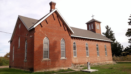
| Description | : | From Cutler's 1883 "History of the State of Kansas," Doniphan County, Geary City: The Norwegian Lutheran Church is located in Wayne Township, Doniphan County, and was built in 1871, and dedicated the same year. The first preacher was the Rev. Mr. Brown, a native of Norway. He was succeeded by the Rev. Mr. Hendrickson. He preached about two years and was succeeded by the Rev. Mr. Rorhnis. He preached about two years and was the last preacher, and left about two years ago. The land on which the church stands contains about half an acre, and was donated by Mr.... Read More |
frequently asked questions (FAQ):
-
Where is Norwegian Lutheran Church Cemetery?
Norwegian Lutheran Church Cemetery is located at Doniphan County ,Kansas ,USA.
-
Norwegian Lutheran Church Cemetery cemetery's updated grave count on graveviews.com?
0 memorials
-
Where are the coordinates of the Norwegian Lutheran Church Cemetery?
Latitude: 39.6749900
Longitude: -95.0425000
Nearby Cemetories:
1. Doniphan Cemetery
Doniphan, Doniphan County, USA
Coordinate: 39.6478004, -95.0699997
2. Rosedale Cemetery
Troy, Doniphan County, USA
Coordinate: 39.7111015, -95.0113983
3. Lutheran Cemetery
Marion Township, Doniphan County, USA
Coordinate: 39.7261391, -95.0307922
4. Myers Cemetery
Atchison, Atchison County, USA
Coordinate: 39.6369019, -95.1149979
5. Gore-Cummings-Nielson-Armstrong-Case Cemetery
Shannon, Atchison County, USA
Coordinate: 39.6241989, -95.1128006
6. Kerlin Cemetery
Halls, Buchanan County, USA
Coordinate: 39.6246986, -94.9672012
7. Armstrong Cemetery
Rushville, Buchanan County, USA
Coordinate: 39.5960999, -95.0083008
8. Dicksen Cemetery
Rushville, Buchanan County, USA
Coordinate: 39.5889100, -95.0220400
9. Jordan Creek Cemetery
Bendena, Doniphan County, USA
Coordinate: 39.6816406, -95.1593781
10. Fenton Grave
Buchanan County, USA
Coordinate: 39.5923700, -94.9844900
11. Palermo Cemetery
Palermo, Doniphan County, USA
Coordinate: 39.7519700, -94.9709400
12. Orphans Home Cemetery
Atchison, Atchison County, USA
Coordinate: 39.5934906, -95.1105728
13. Daniel Jones Cemetery
Rushville, Buchanan County, USA
Coordinate: 39.5852318, -94.9851913
14. Taylor Cemetery
Atchison, Atchison County, USA
Coordinate: 39.5867200, -95.1055400
15. Saint Charles Cemetery
Troy, Doniphan County, USA
Coordinate: 39.7686005, -95.0971985
16. Mount Calvary Cemetery
Atchison, Atchison County, USA
Coordinate: 39.5971985, -95.1311035
17. Fist Cemetery
Buchanan County, USA
Coordinate: 39.5763000, -95.0014000
18. Mount Olive Cemetery
Troy, Doniphan County, USA
Coordinate: 39.7677994, -95.1044006
19. Sunset Memory Gardens
Atchison, Atchison County, USA
Coordinate: 39.5978203, -95.1342621
20. Black Family Cemetery
Rushville, Buchanan County, USA
Coordinate: 39.5773500, -94.9898400
21. Cash Cemetery
Rushville, Buchanan County, USA
Coordinate: 39.5702400, -95.0220600
22. Mount Calvary Cemetery
Wathena, Doniphan County, USA
Coordinate: 39.7599297, -94.9595108
23. Hudspeth Cemetery
Rushville, Buchanan County, USA
Coordinate: 39.5682100, -95.0400000
24. Allison Homestead Graveyard
Rushville, Buchanan County, USA
Coordinate: 39.5659100, -95.0211900