
| Memorials | : | 0 |
| Location | : | Mize, Smith County, USA |
| Coordinate | : | 31.7933100, -89.5686700 |
| Description | : | From Mize, MS proceed South on Mississippi Highway 35 (MS 35 aka Oak Street) 4 miles to the intersection of Smith County Road 45 (SCR 45.) Turn Left (South) onto SCR 45 and proceed 2.1 miles to the intersection of Smith County Road 28 (SCR 28.) Turn Left (East) onto SCR 28 and ontinue approximately one tenth of a mile, cemetery will be on both sides of the road, specifically SW1/4 NW1/4, S36, T10N-R16W, Smith, Mize Quadrangle map, USNG 16R BA 56839 20359. |
frequently asked questions (FAQ):
-
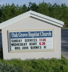
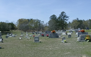
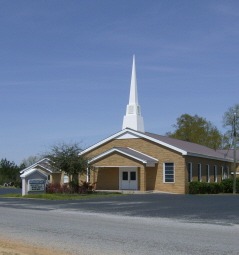
Where is Oak Grove Baptist Church Cemetery?
Oak Grove Baptist Church Cemetery is located at 507 Smith County Road 28 Mize, Smith County ,Mississippi , 39116USA.
-
Oak Grove Baptist Church Cemetery cemetery's updated grave count on graveviews.com?
0 memorials
-
Where are the coordinates of the Oak Grove Baptist Church Cemetery?
Latitude: 31.7933100
Longitude: -89.5686700
Nearby Cemetories:
1. Old Zion Hill Cemetery
Mize, Smith County, USA
Coordinate: 31.7999900, -89.5438700
2. Maranatha Baptist Cemetery
Mize, Smith County, USA
Coordinate: 31.8102880, -89.5921820
3. Alex Sullivan Cemetery
Mize, Smith County, USA
Coordinate: 31.8249400, -89.5608000
4. Pleasant Hill Landmark Missionary Baptist Church C
Mount Olive, Covington County, USA
Coordinate: 31.7834200, -89.6106100
5. Rutland Cemetery
Covington County, USA
Coordinate: 31.7611008, -89.5916977
6. Shiloh Cemetery
Smith, Covington County, USA
Coordinate: 31.7556000, -89.5792007
7. Thomas F Sullivans Cemetery
Mize, Smith County, USA
Coordinate: 31.8335200, -89.5696100
8. Jesus Name Holy Hill
Mount Olive, Covington County, USA
Coordinate: 31.7541850, -89.5531740
9. Zion Hill Missionary Baptist Church Cemetery
Mize, Smith County, USA
Coordinate: 31.8359394, -89.5683136
10. New Sardis Baptist Church Cemetery
Smith County, USA
Coordinate: 31.8099500, -89.6168700
11. Apostolic Church of Jesus Christ Cemetery
Mount Olive, Covington County, USA
Coordinate: 31.7518860, -89.5450100
12. New Liberty Landmark Baptist Church Cemetery
Smith County, USA
Coordinate: 31.7903500, -89.5116800
13. Eubanks Cemetery
Mize, Smith County, USA
Coordinate: 31.8002663, -89.6283493
14. Berkhalter Cemetery
Covington County, USA
Coordinate: 31.7558002, -89.5263977
15. Tom Sullivan Cemetery
Mize, Smith County, USA
Coordinate: 31.7999992, -89.6294022
16. Ed Sullivan Cemetery
Mize, Smith County, USA
Coordinate: 31.8439500, -89.5484300
17. Lilly Valley Missionary Baptist Church Cemetery
Mount Olive, Covington County, USA
Coordinate: 31.7687740, -89.5074290
18. Blakely Creek Baptist Church Cemetery
Covington County, USA
Coordinate: 31.7355995, -89.5671997
19. Old Miller Cemetery
Taylorsville, Smith County, USA
Coordinate: 31.8005409, -89.5008545
20. Byrd Cemetery
Mize, Smith County, USA
Coordinate: 31.8500920, -89.5831400
21. Springhill Landmark Baptist Church Cemetery
Mount Olive, Covington County, USA
Coordinate: 31.7374554, -89.5960617
22. Calvary Cemetery
Mize, Smith County, USA
Coordinate: 31.8526400, -89.6007700
23. Mize Cemetery
Mize, Smith County, USA
Coordinate: 31.8576794, -89.5548096
24. Pleasant Hills Mennonite Cemetery
Mize, Smith County, USA
Coordinate: 31.8613850, -89.5787720