
| Memorials | : | 23 |
| Location | : | Ray County, USA |
| Coordinate | : | 39.2433281, -94.1977005 |
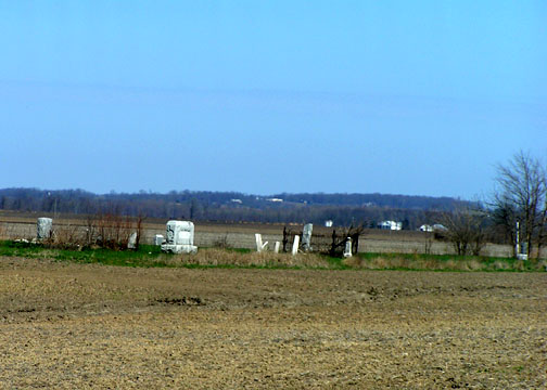
| Description | : | The cemetery is in poor shape, only a few stones remain in the original spots, most are grouped around a central crypt. Located in a field behind a farm house on S. Union Rd, hard to see from the main road though you can see Union Baptist Church as well as Dillen Cemetery. |
frequently asked questions (FAQ):
-
Where is Old Allen Cemetery?
Old Allen Cemetery is located at Ray County ,Missouri ,USA.
-
Old Allen Cemetery cemetery's updated grave count on graveviews.com?
23 memorials
-
Where are the coordinates of the Old Allen Cemetery?
Latitude: 39.2433281
Longitude: -94.1977005
Nearby Cemetories:
1. Union Baptist Cemetery
Orrick, Ray County, USA
Coordinate: 39.2507133, -94.1969070
2. Bogart Family Cemetery
Ray County, USA
Coordinate: 39.2644400, -94.1777800
3. Elitzer Cemetery
Miltondale, Clay County, USA
Coordinate: 39.2595640, -94.2289210
4. Riffe Cemetery
Orrick, Ray County, USA
Coordinate: 39.2514000, -94.1492004
5. Oldham Cemetery
Sibley, Jackson County, USA
Coordinate: 39.2037500, -94.2261400
6. Moore Cemetery
Excelsior Springs, Clay County, USA
Coordinate: 39.2696991, -94.2530975
7. Siegel Cemetery
Excelsior Springs, Ray County, USA
Coordinate: 39.2943993, -94.1977997
8. Dixon Family Cemetery
Fort Osage Township, Jackson County, USA
Coordinate: 39.1965120, -94.2247932
9. Scott Cemetery
Clay County, USA
Coordinate: 39.2708015, -94.2538986
10. Rowland Cemetery
Ray County, USA
Coordinate: 39.2694016, -94.1389008
11. Enon Cemetery
Excelsior Springs, Clay County, USA
Coordinate: 39.2958984, -94.2221985
12. Sibley Cemetery
Sibley, Jackson County, USA
Coordinate: 39.1853981, -94.1940994
13. Tucker-Gryder Cemetery
Richmond, Ray County, USA
Coordinate: 39.2411800, -94.1198700
14. Stokes Cemetery
Ray County, USA
Coordinate: 39.2270600, -94.1225900
15. Old Albany Cemetery
Orrick, Ray County, USA
Coordinate: 39.2265885, -94.1210713
16. Rock Falls Church Cemetery
Elkhorn, Ray County, USA
Coordinate: 39.2893500, -94.1221800
17. O'Dell Cemetery
Excelsior Springs, Ray County, USA
Coordinate: 39.2995987, -94.1346970
18. Missouri City Cemetery
Missouri City, Clay County, USA
Coordinate: 39.2417297, -94.2970734
19. South Point Cemetery
Orrick, Ray County, USA
Coordinate: 39.2233009, -94.0978012
20. Dorton Cemetery
Orrick, Ray County, USA
Coordinate: 39.1960900, -94.1137100
21. Lewis Cemetery
Orrick, Ray County, USA
Coordinate: 39.2386017, -94.0935974
22. Buxton Cemetery
Prathersville, Clay County, USA
Coordinate: 39.2780991, -94.2919006
23. Old New Garden Primitive Baptist Cemetery
Wood Heights, Ray County, USA
Coordinate: 39.3227005, -94.1669006
24. Bates Cemetery
Ray County, USA
Coordinate: 39.2385200, -94.0892300