
| Memorials | : | 1 |
| Location | : | Elkhorn, Ray County, USA |
| Coordinate | : | 39.2893500, -94.1221800 |
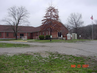
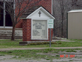
| Description | : | Rock Falls Baptist Church has been in Ray County since 1877 1 mile south of Elkhorn on "N" Hwy, 1/2 mile west on Rock Falls Road #5 on Ray County History 1973 Cemetery Map, p. 230 This small cemetery sits on top of a hill due south of the Rock Falls Baptist Church. According to elderly members of the church, five small children are buried there. No one seems to know with any certainty who these five children were. The church placed a marker at the small cemetery years ago identifying the cemetery. The five children's graves are only marked by... Read More |
frequently asked questions (FAQ):
-
Where is Rock Falls Church Cemetery?
Rock Falls Church Cemetery is located at Elkhorn, Ray County ,Missouri ,USA.
-
Rock Falls Church Cemetery cemetery's updated grave count on graveviews.com?
1 memorials
-
Where are the coordinates of the Rock Falls Church Cemetery?
Latitude: 39.2893500
Longitude: -94.1221800
Nearby Cemetories:
1. O'Dell Cemetery
Excelsior Springs, Ray County, USA
Coordinate: 39.2995987, -94.1346970
2. Pettus Cemetery
Elkhorn, Ray County, USA
Coordinate: 39.2935982, -94.0988998
3. Rowland Cemetery
Ray County, USA
Coordinate: 39.2694016, -94.1389008
4. Brand Family Cemetery
Richmond, Ray County, USA
Coordinate: 39.2864600, -94.0908800
5. Cravens Headstone
Ray County, USA
Coordinate: 39.3134300, -94.1080300
6. Hamilton Cemetery
Ray County, USA
Coordinate: 39.3107986, -94.1007996
7. Covey Cemetery
Ray County, USA
Coordinate: 39.2702713, -94.0865707
8. JB Tombstone
Richmond, Ray County, USA
Coordinate: 39.2702713, -94.0865707
9. Riffe Cemetery
Orrick, Ray County, USA
Coordinate: 39.2514000, -94.1492004
10. Gordon Cemetery
Orrick, Ray County, USA
Coordinate: 39.2552986, -94.0871964
11. Old New Garden Primitive Baptist Cemetery
Wood Heights, Ray County, USA
Coordinate: 39.3227005, -94.1669006
12. Tucker-Gryder Cemetery
Richmond, Ray County, USA
Coordinate: 39.2411800, -94.1198700
13. Bogart Family Cemetery
Ray County, USA
Coordinate: 39.2644400, -94.1777800
14. North New Garden Primitive Baptist Church Cemetery
Wood Heights, Ray County, USA
Coordinate: 39.3271027, -94.1648026
15. Windy Hill Cemetery
Wood Heights, Ray County, USA
Coordinate: 39.3407364, -94.1462250
16. Lewis Cemetery
Orrick, Ray County, USA
Coordinate: 39.2386017, -94.0935974
17. Bates Cemetery
Ray County, USA
Coordinate: 39.2385200, -94.0892300
18. Thomas A. Brown Cemetery
Richmond, Ray County, USA
Coordinate: 39.2503300, -94.0654800
19. Siegel Cemetery
Excelsior Springs, Ray County, USA
Coordinate: 39.2943993, -94.1977997
20. Sanderson Cemetery
Rayville, Ray County, USA
Coordinate: 39.3333015, -94.0699997
21. Todds Chapel Cemetery
Richmond, Ray County, USA
Coordinate: 39.2864000, -94.0448000
22. Stokes Cemetery
Ray County, USA
Coordinate: 39.2270600, -94.1225900
23. Old Albany Cemetery
Orrick, Ray County, USA
Coordinate: 39.2265885, -94.1210713
24. Pisgah Cemetery
Wood Heights, Ray County, USA
Coordinate: 39.3376846, -94.1775055