
| Memorials | : | 0 |
| Location | : | Bunceton, Cooper County, USA |
| Coordinate | : | 38.7999520, -92.8797250 |
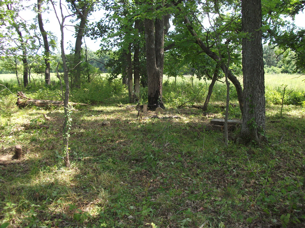
| Description | : | Pilot Grove South West Northwest of Bunceton Township 47-N; Range 18-W NW Quarter of NE Quarter of Section 34 The old Mount Nebo Church Cemetery is located on private land, which used to be the farm of Carl Cole. It is in a small, round grove of trees. As of 2014, the cemetery itself is in very poor condition. The entire area is overgrown. Many of the gravestones, which were simply rocks with initials, are no longer legible. |
frequently asked questions (FAQ):
-
Where is Old Mount Nebo Cemetery?
Old Mount Nebo Cemetery is located at Bunceton, Cooper County ,Missouri ,USA.
-
Old Mount Nebo Cemetery cemetery's updated grave count on graveviews.com?
0 memorials
-
Where are the coordinates of the Old Mount Nebo Cemetery?
Latitude: 38.7999520
Longitude: -92.8797250
Nearby Cemetories:
1. Mount Nebo Baptist Church and Cemetery
Pilot Grove, Cooper County, USA
Coordinate: 38.8034970, -92.8896760
2. Briscoe Cemetery
Cooper County, USA
Coordinate: 38.8025017, -92.8535995
3. Bethlehem Cemetery
Bunceton, Cooper County, USA
Coordinate: 38.7510630, -92.8613010
4. Sunset Hills Cemetery
Bunceton, Cooper County, USA
Coordinate: 38.7846140, -92.8033260
5. New Lebanon Cumberland Presbyterian Church Cemeter
Pilot Grove, Cooper County, USA
Coordinate: 38.7601070, -92.9405180
6. Masonic Cemetery
Bunceton, Cooper County, USA
Coordinate: 38.7947006, -92.8000031
7. Mount Vernon Cemetery
Pilot Grove, Cooper County, USA
Coordinate: 38.8586006, -92.9150009
8. Carpenter Family Cemetery
Syracuse, Morgan County, USA
Coordinate: 38.7417910, -92.9189220
9. Saint Joseph's Catholic Cemetery
Pilot Grove, Cooper County, USA
Coordinate: 38.8636017, -92.9088974
10. Wesley Chapel Cemetery
Pilot Grove, Cooper County, USA
Coordinate: 38.8626750, -92.9235120
11. Antioch Cemetery
Cooper County, USA
Coordinate: 38.7369003, -92.9231033
12. Bethel Memorial Gardens
Speed, Cooper County, USA
Coordinate: 38.8538100, -92.8111400
13. Garibaldi Mausoleum
Carano, Provincia di Latina, Italy
Coordinate: 38.8747215, -92.9113922
14. Concord Cemetery
Cooper County, USA
Coordinate: 38.8199997, -92.7799988
15. Lone Elm Christian Cemetery
Lone Elm, Cooper County, USA
Coordinate: 38.8211210, -92.7785260
16. Pilot Grove City Cemetery
Pilot Grove, Cooper County, USA
Coordinate: 38.8788930, -92.9131360
17. Pleasant Green Cemetery
Pleasant Green, Cooper County, USA
Coordinate: 38.8016950, -92.9903690
18. Pleasant Green Methodist Church Old Cemetery
Cooper County, USA
Coordinate: 38.8013480, -92.9911630
19. Saint Paul Cemetery Old
Pilot Grove, Cooper County, USA
Coordinate: 38.8631010, -92.9718320
20. Saint Paul Cemetery New
Pilot Grove, Cooper County, USA
Coordinate: 38.8642350, -92.9722930
21. Saint John's Cemetery
Clear Creek, Cooper County, USA
Coordinate: 38.8600660, -92.9772640
22. Mount Moriah Cemetery
Clifton City, Cooper County, USA
Coordinate: 38.7758710, -93.0035870
23. Chilton Cemetery
Bunceton, Cooper County, USA
Coordinate: 38.7472000, -92.7694016
24. Pleasant Hill Cemetery
Cooper County, USA
Coordinate: 38.8955994, -92.8383026