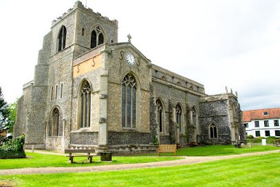
| Memorials | : | 0 |
| Location | : | Attleborough, Breckland Borough, England |
| Coordinate | : | 52.5167420, 1.0209100 |
| Description | : | Attleborough is a market town and civil parish in Norfolk, England situated between Norwich and Thetford. The parish falls within the district of Breckland. The Anglo-Saxon foundation of the settlement is unrecorded. A popular theory of the town's origin makes it a foundation of an Atlinge, and certainly burgh (or burh) indicates that it was fortified at an early date. According to the mid-twelfth-century hagiographer of Saint Edmund, Galfridus de Fontibus, Athla was the founder of the Ancient and royal town of Attleborough in Norfolk. In the Doomsday survey launched in 1085 it is referred to as Attleburc. After the... Read More |
frequently asked questions (FAQ):
-
Where is Parkside Garden?
Parkside Garden is located at Thieves Lane Attleborough, Breckland Borough ,Norfolk ,England.
-
Parkside Garden cemetery's updated grave count on graveviews.com?
0 memorials
-
Where are the coordinates of the Parkside Garden?
Latitude: 52.5167420
Longitude: 1.0209100
Nearby Cemetories:
1. Blessed Virgin Mary Churchyard
Attleborough, Breckland Borough, England
Coordinate: 52.5178950, 1.0181880
2. Attleborough Cemetery
Attleborough, Breckland Borough, England
Coordinate: 52.5206640, 1.0157790
3. All Saints Churchyard
Besthorpe, Breckland Borough, England
Coordinate: 52.5192800, 1.0431370
4. Buckenham Priory
Buckenham, Broadland District, England
Coordinate: 52.4911000, 1.0497000
5. St. James Churchyard
Great Ellingham, Breckland Borough, England
Coordinate: 52.5347590, 0.9774180
6. St. Peter's Chapel
Morley Saint Botolph, South Norfolk District, England
Coordinate: 52.5464700, 1.0416520
7. All Saints Churchyard
Old Buckenham, Breckland Borough, England
Coordinate: 52.4816260, 1.0433160
8. All Saints Churchyard Hargham
Quideham, Breckland Borough, England
Coordinate: 52.4826470, 0.9732300
9. St. Andrew's Churchyard
Deopham, South Norfolk District, England
Coordinate: 52.5635040, 1.0224710
10. St. Botolphs Churchyard
Morley Saint Botolph, South Norfolk District, England
Coordinate: 52.5601960, 1.0512010
11. All Saints Churchyard
Rocklands, Breckland Borough, England
Coordinate: 52.5253020, 0.9385050
12. Theddingworth Congregational Church yard
Theddingworth, Harborough District, England
Coordinate: 52.4644400, 1.0211700
13. St. Peter's Churchyard
Little Ellingham, Breckland Borough, England
Coordinate: 52.5531500, 0.9560740
14. St. Martin's Churchyard
New Buckenham, Breckland Borough, England
Coordinate: 52.4728860, 1.0728380
15. St. Peter's Cemetery
Rockland St Peter, Breckland Borough, England
Coordinate: 52.5349241, 0.9327301
16. St Peter Churchyard
Rocklands, Breckland Borough, England
Coordinate: 52.5350220, 0.9325260
17. St. Mary the Virgin Churchyard
Eccles, Breckland Borough, England
Coordinate: 52.4649373, 0.9707904
18. St Mary's Churchyard Extension
Banham, Breckland Borough, England
Coordinate: 52.4549400, 1.0274400
19. All Saints Churchyard
Carleton Rode, South Norfolk District, England
Coordinate: 52.4892230, 1.1133590
20. St. Mary's Churchyard
Deopham, South Norfolk District, England
Coordinate: 52.5788950, 1.0377920
21. All Saints Churchyard
Snetterton, Breckland Borough, England
Coordinate: 52.4807600, 0.9350140
22. St. Peter & St. Paul Churchyard
Shropham, Breckland Borough, England
Coordinate: 52.4968770, 0.9217990
23. Carleton Rode Baptist Churchyard
Carleton Rode, South Norfolk District, England
Coordinate: 52.4937320, 1.1185210
24. St. Mary the Virgin Churchyard
Banham, Breckland Borough, England
Coordinate: 52.4529230, 1.0353120

