
| Memorials | : | 1 |
| Location | : | Lowgap, Surry County, USA |
| Coordinate | : | 36.4947220, -80.7928060 |
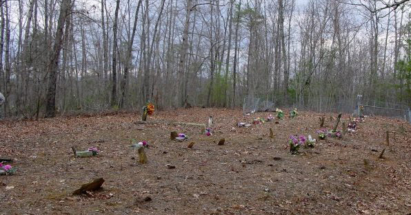
| Description | : | Directions: From intersection of US Hwy 52 N and NC Hwy 89 W (W. Pine St.) in Mt. Airy, go west on NC Hwy 89 for 9.2 miles and turn right on Beulah Church Rd (SR 1345). Then go 2 miles and turn right on Leroy Gillespie Rd. Then go about .1 mile to large oak tree on right (near green vertical utility box) and from the oak tree walk directly into woods to the top of knoll. Distance from road to the cemetery is about 400' - 500'. There are 28 fieldstones and graves identified. |
frequently asked questions (FAQ):
-
Where is Payne Cemetery?
Payne Cemetery is located at Lowgap, Surry County ,North Carolina ,USA.
-
Payne Cemetery cemetery's updated grave count on graveviews.com?
0 memorials
-
Where are the coordinates of the Payne Cemetery?
Latitude: 36.4947220
Longitude: -80.7928060
Nearby Cemetories:
1. Beulah United Methodist Church Cemetery
Beulah, Surry County, USA
Coordinate: 36.4865160, -80.7795830
2. Moore Family Cemetery
Mount Airy, Surry County, USA
Coordinate: 36.4919910, -80.7741450
3. Round Peak Primitive Baptist Church Cemetery
Round Peak, Surry County, USA
Coordinate: 36.5145264, -80.7861633
4. Mount Vernon Baptist Church Cemetery
Beulah, Surry County, USA
Coordinate: 36.5003624, -80.8213882
5. Country Baptist Church Cemetery
Beulah, Surry County, USA
Coordinate: 36.4662230, -80.7760980
6. Holy Cross Missionary Baptist Church Cemetery
Beulah, Surry County, USA
Coordinate: 36.4702640, -80.7655040
7. Oak Grove Baptist Church Cemetery
Oak Grove (Bottom), Surry County, USA
Coordinate: 36.4788770, -80.7540890
8. McCraw Cemetery
Beulah, Surry County, USA
Coordinate: 36.4671370, -80.7626220
9. Sarah Isaacs Cemetery
Franklin, Surry County, USA
Coordinate: 36.4636110, -80.8205830
10. Maple Springs Baptist Church Cemetery
Beulah, Surry County, USA
Coordinate: 36.4627180, -80.7653560
11. Ladonia Baptist Church Cemetery
Ladonia, Surry County, USA
Coordinate: 36.4780280, -80.8386670
12. Isaacks Family Cemetery
Mount Airy, Surry County, USA
Coordinate: 36.4621670, -80.8236670
13. Flat Top Primitive Baptist Church Cemetery
Beulah, Surry County, USA
Coordinate: 36.4570000, -80.7730000
14. Holder Cemetery
Lowgap, Surry County, USA
Coordinate: 36.5364670, -80.7875720
15. Jarrell Family Graveyard
Lowgap, Surry County, USA
Coordinate: 36.5362520, -80.7798310
16. New Life Baptist Cemetery
Mount Airy, Surry County, USA
Coordinate: 36.4524994, -80.8030548
17. Amazing Grace Baptist Church Cemetery
Ladonia, Surry County, USA
Coordinate: 36.4588700, -80.8254250
18. Ivy Green Baptist Church Cemetery
Crooked Oak, Surry County, USA
Coordinate: 36.5381927, -80.7771683
19. Edwards-Franklin House Grounds
Mount Airy, Surry County, USA
Coordinate: 36.4541664, -80.8181915
20. Zion Hill Primitive Baptist Church Cemetery
Crooked Oak, Surry County, USA
Coordinate: 36.5313339, -80.7572250
21. Barker Graveyard
Lowgap, Surry County, USA
Coordinate: 36.5295540, -80.8340600
22. Golding Family Cemetery
Mount Airy, Surry County, USA
Coordinate: 36.5326670, -80.7528330
23. Jarrell Family Cemetery
Lowgap, Surry County, USA
Coordinate: 36.5427860, -80.8103660
24. Nixon Family Cemetery
Surry County, USA
Coordinate: 36.4445830, -80.7949720