
| Memorials | : | 0 |
| Location | : | Pocopson, Chester County, USA |
| Coordinate | : | 39.8977440, -75.6413930 |
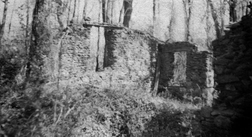
| Description | : | Pennsbury Union American Methodist Episcopal Church was founded in 1827, when Black landowners John and Angelina Smith sold a ¼-acre lot in Pennsbury Township to John Malden [Maulden], James Ramen [Raymond], David Hockins, John Williams, and Richard Brown, Trustees of the African Union Church, "that they shall erect a House for public worship for religious society of African Unions, to be governed by same discipline as African Union Church in Wilmington in the State of Delaware." A congregation quickly formed from the mass of rural Black tenant farmers which inhabited the countryside on the west side of the Brandywine. In... Read More |
frequently asked questions (FAQ):
-
Where is Pennsbury Union American Methodist Episcopal Cemetery?
Pennsbury Union American Methodist Episcopal Cemetery is located at Denton Hollow Rd Pocopson, Chester County ,Pennsylvania ,USA.
-
Pennsbury Union American Methodist Episcopal Cemetery cemetery's updated grave count on graveviews.com?
0 memorials
-
Where are the coordinates of the Pennsbury Union American Methodist Episcopal Cemetery?
Latitude: 39.8977440
Longitude: -75.6413930
Nearby Cemetories:
1. Parkersville Friends Meeting Cemetery
Parkersville, Chester County, USA
Coordinate: 39.8861008, -75.6447983
2. Old Kennett Friends Cemetery
Kennett Square, Chester County, USA
Coordinate: 39.8717041, -75.6472092
3. Birmingham-Lafayette Cemetery
Birmingham, Chester County, USA
Coordinate: 39.9063988, -75.5942001
4. Birmingham Orthodox Friends Burial Ground
Birmingham, Chester County, USA
Coordinate: 39.9043700, -75.5927740
5. Longwood Cemetery
Kennett Square, Chester County, USA
Coordinate: 39.8680496, -75.6728821
6. Church of the Loving Shepherd Memorial Garden
West Chester, Chester County, USA
Coordinate: 39.9241200, -75.5995680
7. Marlborough Friends Burial Ground
Marlboro, Chester County, USA
Coordinate: 39.8953000, -75.7044000
8. Westminster Presbyterian Church Memorial Gardens
West Chester, Chester County, USA
Coordinate: 39.9264570, -75.5832770
9. Ebenezer African Methodist Episcopal Cemetery
Unionville, Chester County, USA
Coordinate: 39.8888830, -75.7137970
10. Brandywine Baptist Church Cemetery
Chadds Ford, Delaware County, USA
Coordinate: 39.8741226, -75.5733566
11. Bradford Cemetery
Marshallton, Chester County, USA
Coordinate: 39.9474800, -75.6809000
12. Calvary Lutheran Church Columbarium
West Chester, Chester County, USA
Coordinate: 39.9491036, -75.6026425
13. Archie's Corner Cemetery
Chadds Ford, Delaware County, USA
Coordinate: 39.8655396, -75.5762405
14. Marshallton United Methodist Church Cemetery
Marshallton, Chester County, USA
Coordinate: 39.9506989, -75.6769028
15. Bradford Friends Burying Ground
Marshallton, Chester County, USA
Coordinate: 39.9497000, -75.6802000
16. Saint Michael Lutheran Church Columbarium
Unionville, Chester County, USA
Coordinate: 39.8926920, -75.7191700
17. Brinton Homestead Cemetery
Thornbury Township, Delaware County, USA
Coordinate: 39.8967120, -75.5586500
18. Saint Agnes Roman Catholic Church Grounds
West Chester, Chester County, USA
Coordinate: 39.9590876, -75.6088266
19. Holy Trinity Episcopal Church Memorial Garden
West Chester, Chester County, USA
Coordinate: 39.9574630, -75.6024650
20. Unionville Cemetery
Unionville, Chester County, USA
Coordinate: 39.8950310, -75.7296066
21. Saint Patrick Roman Catholic Cemetery
Kennett Square, Chester County, USA
Coordinate: 39.8546982, -75.7146988
22. Union Hill Cemetery
Kennett Square, Chester County, USA
Coordinate: 39.8544006, -75.7161026
23. State Street Friends Cemetery (Defunct)
Kennett Square, Chester County, USA
Coordinate: 39.8469195, -75.7087515
24. Chester County Alms House Cemeteries
Newlin Township, Chester County, USA
Coordinate: 39.9319000, -75.7255000