
| Memorials | : | 0 |
| Location | : | Baldwin, Gilmer County, USA |
| Coordinate | : | 38.9891200, -80.7289800 |
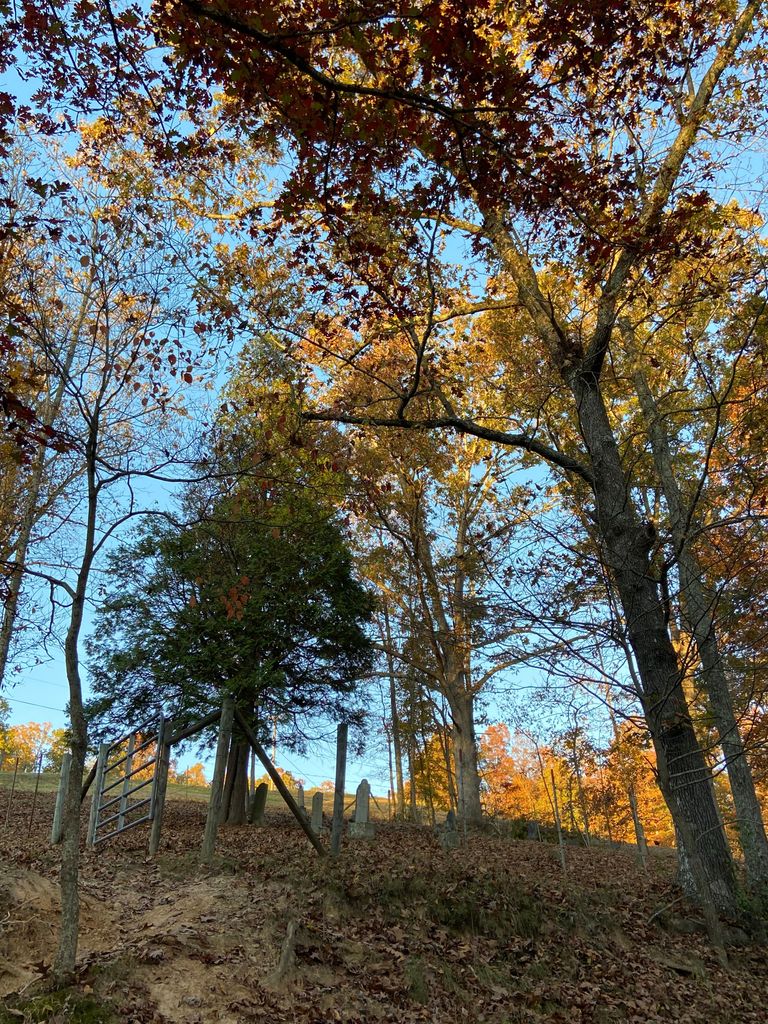
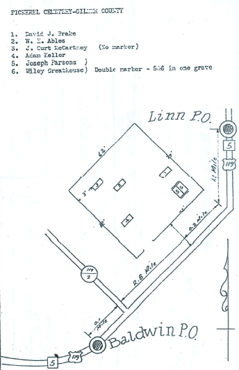
| Description | : | Cemetery Location: From Glenville, Gilmer Co., WV., go east on US Hwy 33 & 119 towards Weston. About eight miles east of Glenville, near the top of Stewarts Creek Hill, (Ellis Road at the top of the hill), just a few yards west of the highway, is the Pickerel Cemetery. This cemetery is unfenced and not in very good condition. |
frequently asked questions (FAQ):
-
Where is Pickerel Cemetery?
Pickerel Cemetery is located at Baldwin, Gilmer County ,West Virginia ,USA.
-
Pickerel Cemetery cemetery's updated grave count on graveviews.com?
0 memorials
-
Where are the coordinates of the Pickerel Cemetery?
Latitude: 38.9891200
Longitude: -80.7289800
Nearby Cemetories:
1. Hiney Hill Cemetery
Linn, Gilmer County, USA
Coordinate: 38.9676950, -80.7405600
2. Messenger Cemetery
Gilmer County, USA
Coordinate: 38.9714012, -80.7572021
3. Farnsworth Cemetery
Linn, Gilmer County, USA
Coordinate: 39.0177994, -80.7378006
4. Rock Grove Cemetery
Latonia, Gilmer County, USA
Coordinate: 39.0125008, -80.7018967
5. Keith Cemetery
Gilmer County, USA
Coordinate: 38.9561005, -80.6986008
6. Old Field Fork Cemetery
Lewis County, USA
Coordinate: 38.9827995, -80.6710968
7. Troy IOOF Community Cemetery
Troy, Gilmer County, USA
Coordinate: 39.0281170, -80.7679560
8. Conrad Cemetery
Sand Fork, Gilmer County, USA
Coordinate: 38.9364014, -80.7296982
9. Snyder Cemetery Stewarts Creek
Glenville, Gilmer County, USA
Coordinate: 38.9577800, -80.7836100
10. Moneypenny Cemetery
Alum Bridge, Lewis County, USA
Coordinate: 39.0281466, -80.6809317
11. Schoonover-Dawson Cemetery
Donlan, Gilmer County, USA
Coordinate: 38.9461770, -80.6854790
12. McHenry Cemetery #1
Sand Fork, Gilmer County, USA
Coordinate: 38.9353310, -80.7162630
13. Carder Cemetery
Vadis, Lewis County, USA
Coordinate: 39.0433006, -80.7142029
14. Woofter Cemetery
Alum Bridge, Lewis County, USA
Coordinate: 39.0299988, -80.6808014
15. Rogers Cemetery
Gilmer County, USA
Coordinate: 38.9406013, -80.6936035
16. McHenry Cemetery
Gilmer County, USA
Coordinate: 38.9341870, -80.7130200
17. Boilon Cemetery
Gilmer County, USA
Coordinate: 38.9519005, -80.6718979
18. Dyer Cemetery
Gilmer County, USA
Coordinate: 38.9319000, -80.7110977
19. Varner Cemetery
Sand Fork, Gilmer County, USA
Coordinate: 38.9254709, -80.7212012
20. Leading Creek Baptist Church Cemetery
Alice, Gilmer County, USA
Coordinate: 38.9969000, -80.8183700
21. Killingsworth Cemetery
Sand Fork, Gilmer County, USA
Coordinate: 38.9169640, -80.7249834
22. Sand Fork Cemetery
Gilmer County, USA
Coordinate: 38.9158890, -80.7480520
23. Otterbein Cemetery
Glenville, Gilmer County, USA
Coordinate: 38.9298550, -80.7916820
24. Blackburn Cemetery
Blackburn, Gilmer County, USA
Coordinate: 38.9235700, -80.6743200