
| Memorials | : | 13 |
| Location | : | Motueka, Tasman District, New Zealand |
| Coordinate | : | -41.1059000, 173.0211850 |
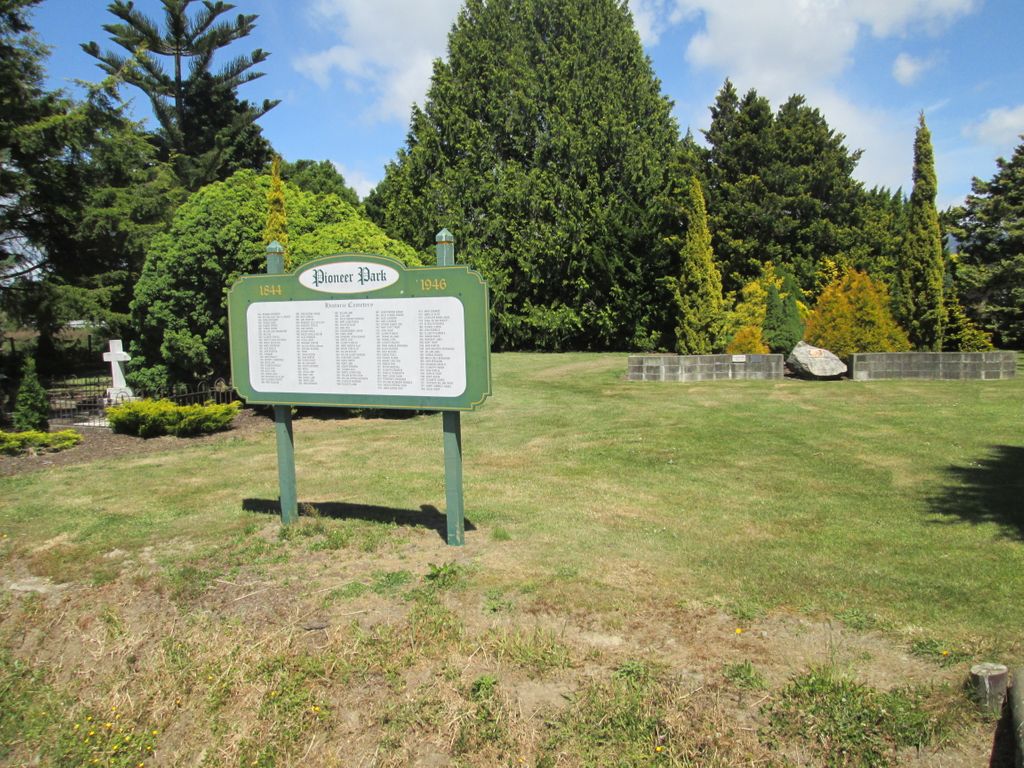
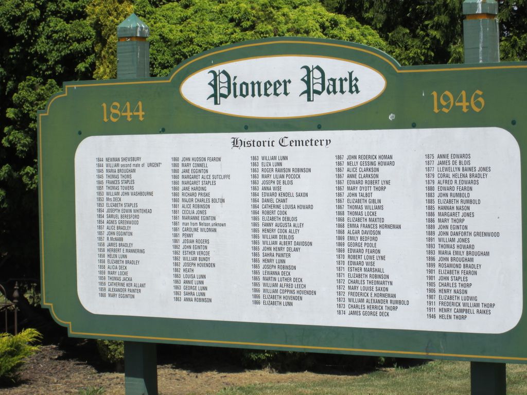
| Description | : | Pioneer Park, Motueka (closed). Pioneer Park incorporates the old graveyard for St. Thomas's Anglican Church which used to be located at this site in Thorp Street. The church is now located in the Motueka High Street. A number of genealogical records still refer to burials located here as being at 'St Thomas's Churchyard' and/or 'St. Thomas's Anglican Churchyard'. |
frequently asked questions (FAQ):
-
Where is Pioneer Park?
Pioneer Park is located at Thorp Street Motueka, Tasman District ,Tasman ,New Zealand.
-
Pioneer Park cemetery's updated grave count on graveviews.com?
13 memorials
-
Where are the coordinates of the Pioneer Park?
Latitude: -41.1059000
Longitude: 173.0211850
Nearby Cemetories:
1. Pah Street Methodist Cemetery
Motueka, Tasman District, New Zealand
Coordinate: -41.1105140, 173.0018140
2. Motueka Cemetery
Motueka, Tasman District, New Zealand
Coordinate: -41.1280550, 173.0198830
3. Riwaka Cemetery
Riwaka, Tasman District, New Zealand
Coordinate: -41.0676130, 172.9848570
4. Pangatotara Cemetery
Pangatotara, Tasman District, New Zealand
Coordinate: -41.1146220, 172.9456110
5. Fletts Cemetery
Lower Moutere, Tasman District, New Zealand
Coordinate: -41.1715560, 172.9992190
6. Sandy Bay Cemetery
Sandy Bay, Tasman District, New Zealand
Coordinate: -41.0177570, 172.9775800
7. Waiwhero Cemetery
Ngatimoti, Tasman District, New Zealand
Coordinate: -41.1879690, 172.9304540
8. Moutere Hills Cemetery
Upper Moutere, Tasman District, New Zealand
Coordinate: -41.2365927, 173.0102027
9. St. Paul's Lutheran Churchyard
Upper Moutere, Tasman District, New Zealand
Coordinate: -41.2703770, 173.0058870
10. Dovedale Cemetery
Dovedale, Tasman District, New Zealand
Coordinate: -41.2900770, 172.8970380
11. Saint Peter & Paul Catholic Churchyard
Appleby, Tasman District, New Zealand
Coordinate: -41.3172800, 173.1117800
12. Saint Alban's Appleby Churchyard
Appleby, Tasman District, New Zealand
Coordinate: -41.3173900, 173.1370900
13. East Takaka Cemetery
East Takaka, Tasman District, New Zealand
Coordinate: -40.9243730, 172.8278290
14. Waimea West Cemetery
Brightwater, Tasman District, New Zealand
Coordinate: -41.3364880, 173.1062950
15. St Michael's Churchyard
Brightwater, Tasman District, New Zealand
Coordinate: -41.3383330, 173.1060180
16. Haulashore Island
Nelson, Nelson City, New Zealand
Coordinate: -41.2691290, 173.2589020
17. Hadfield Family Cemetery at Meadowbank
Tasman District, New Zealand
Coordinate: -40.8619070, 173.0241930
18. Haven Cemetery
Nelson, Nelson City, New Zealand
Coordinate: -41.2732100, 173.2603300
19. Seaview Cemetery
Nelson, Nelson City, New Zealand
Coordinate: -41.3037350, 173.2262930
20. Quaker's Acre
Nelson, Nelson City, New Zealand
Coordinate: -41.2756190, 173.2806640
21. Wakapuaka Cemetery
Nelson, Nelson City, New Zealand
Coordinate: -41.2544590, 173.3032500
22. Hamama West Takaka Cemetery
Takaka, Tasman District, New Zealand
Coordinate: -40.8994520, 172.8101100
23. St Barnabas Anglican Churchyard
Stoke, Nelson City, New Zealand
Coordinate: -41.3126340, 173.2351600
24. St John's Lutheran Churchyard
Hope, Tasman District, New Zealand
Coordinate: -41.3496940, 173.1488400