
| Memorials | : | 6 |
| Location | : | Springville, St. Clair County, USA |
| Phone | : | 205-467-6294 |
| Coordinate | : | 33.8202900, -86.3780600 |
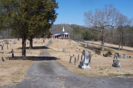
| Description | : | From Birmingham, take I-59 North to Exit 156. Off the ramp turn left crossing over the highway toward Hwy 11 (Main Street). Turn right on Main Street, go about 3.4 miles and make a left onto Washington Valley Road, the church is located on Pleasant Hill Church Drive, and it is on the right off of Washington Valley Road. This cemetery is located next to the church building. |
frequently asked questions (FAQ):
-
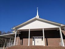
Where is Pleasant Hill United Methodist Church Cemetery?
Pleasant Hill United Methodist Church Cemetery is located at 5537 Washington Valley Road Springville, St. Clair County ,Alabama , 35146USA.
-
Pleasant Hill United Methodist Church Cemetery cemetery's updated grave count on graveviews.com?
5 memorials
-
Where are the coordinates of the Pleasant Hill United Methodist Church Cemetery?
Latitude: 33.8202900
Longitude: -86.3780600
Nearby Cemetories:
1. Straight Mountain Mennonite Church Cemetery
St. Clair County, USA
Coordinate: 33.8479740, -86.3921190
2. Fairview Cemetery
Cool Springs, St. Clair County, USA
Coordinate: 33.7795000, -86.3615670
3. Cool Springs Missionary Baptist Church Cemetery
Ashville, St. Clair County, USA
Coordinate: 33.7920990, -86.3291020
4. Straight Mountain Memory Gardens
Oneonta, Blount County, USA
Coordinate: 33.8735008, -86.3942032
5. Red Hill Baptist Church Cemetery
Springville, St. Clair County, USA
Coordinate: 33.7823610, -86.4296010
6. Saint Clair Springs Baptist Church Cemetery
Springville, St. Clair County, USA
Coordinate: 33.7624741, -86.3933945
7. Moore Cemetery
St. Clair County, USA
Coordinate: 33.8046989, -86.3078003
8. Early Chapel
Whitney, St. Clair County, USA
Coordinate: 33.8684200, -86.3239570
9. Mardis Cemetery
St. Clair County, USA
Coordinate: 33.7542000, -86.4088974
10. Fosters Chapel Cemetery
Straight Mountain, Blount County, USA
Coordinate: 33.8884964, -86.4051132
11. Clements Family Cemetery #2
Straight Mountain, Blount County, USA
Coordinate: 33.8888092, -86.4074402
12. Evergreen United Methodist Church Cemetery
Odenville, St. Clair County, USA
Coordinate: 33.7487000, -86.3456800
13. Hooper Cemetery
St. Clair County, USA
Coordinate: 33.8081017, -86.4697037
14. Reeves Grove Cemetery
Steele, St. Clair County, USA
Coordinate: 33.8708000, -86.3078000
15. Mount Zion Cemetery
Springville, St. Clair County, USA
Coordinate: 33.7774530, -86.4594680
16. Pierce-Braden Cemetery
Odenville, St. Clair County, USA
Coordinate: 33.7532590, -86.4330390
17. Ash-Newton Graveyard
Ashville, St. Clair County, USA
Coordinate: 33.7631700, -86.3048380
18. Springville Cemetery
Springville, St. Clair County, USA
Coordinate: 33.7795400, -86.4720630
19. Bray's Chapel Cemetery
Ashville, St. Clair County, USA
Coordinate: 33.7950800, -86.2733500
20. Whitney Cemetery
Ashville, St. Clair County, USA
Coordinate: 33.8797140, -86.2928910
21. Beason-Union Cemetery
St. Clair County, USA
Coordinate: 33.8913920, -86.3051610
22. Pine Forest Cemetery
St. Clair County, USA
Coordinate: 33.7766620, -86.2763940
23. New Hope Methodist Church Cemetery
Holly Springs, Blount County, USA
Coordinate: 33.8307991, -86.4931030
24. Union Hill Church of the Nazarene Cemetery
Straight Mountain, Blount County, USA
Coordinate: 33.9152960, -86.3541860