
| Memorials | : | 0 |
| Location | : | McCreary County, USA |
| Coordinate | : | 36.6633760, -84.3244200 |
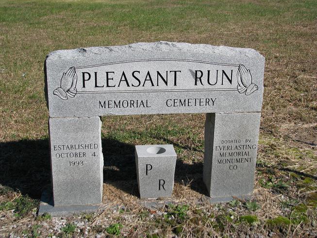
| Description | : | This cemetery was established on October 4-1993 and is not part of the old Pleasant Run Cemetery.It is on the same road and very close to the old one,right before you get to the old one. ALL stones in this cemetery were photographed on 12 Nov 2009 so any Burials before that are in the Old Pleasant Run Cemetery. |
frequently asked questions (FAQ):
-
Where is Pleasant Run Memorial Cemetery?
Pleasant Run Memorial Cemetery is located at McCreary County ,Kentucky ,USA.
-
Pleasant Run Memorial Cemetery cemetery's updated grave count on graveviews.com?
0 memorials
-
Where are the coordinates of the Pleasant Run Memorial Cemetery?
Latitude: 36.6633760
Longitude: -84.3244200
Nearby Cemetories:
1. Pleasant Run Cemetery
Hollyhill, McCreary County, USA
Coordinate: 36.6622391, -84.3222504
2. Davis Hill-William Ball Family
Pine Knot, McCreary County, USA
Coordinate: 36.6631260, -84.3656470
3. Bethel Cemetery
Pine Knot, McCreary County, USA
Coordinate: 36.6866670, -84.3555560
4. Davis Cemetery
Pine Knot, McCreary County, USA
Coordinate: 36.6444440, -84.3683330
5. Moore Family Cemetery
Pine Knot, McCreary County, USA
Coordinate: 36.6648100, -84.3884400
6. Hayes Creek Cemetery
Creekmore, McCreary County, USA
Coordinate: 36.6197014, -84.3591995
7. Neal Cemetery
McCreary County, USA
Coordinate: 36.6405020, -84.3827090
8. Hogue Cemetery
Pine Knot, McCreary County, USA
Coordinate: 36.6852300, -84.3870800
9. Lower Cal Hill Cemetery
Pine Knot, McCreary County, USA
Coordinate: 36.6471800, -84.3909770
10. Cat Hill Cemetery
Pine Knot, McCreary County, USA
Coordinate: 36.6472015, -84.3914032
11. Rock Creek Cemetery
McCreary County, USA
Coordinate: 36.6060982, -84.3189011
12. Holt Cemetery
McCreary County, USA
Coordinate: 36.6088982, -84.3507996
13. Wood Cemetery
Pine Knot, McCreary County, USA
Coordinate: 36.6688100, -84.3972390
14. East Pine Knot Memorial Gardens
Pine Knot, McCreary County, USA
Coordinate: 36.6687700, -84.3972450
15. Chitwood Cemetery
Pine Knot, McCreary County, USA
Coordinate: 36.6691370, -84.3979970
16. Upper Cal Hill Cemetery
Pine Knot, McCreary County, USA
Coordinate: 36.6495590, -84.4008450
17. Stephens Cemetery
Pine Knot, McCreary County, USA
Coordinate: 36.6731811, -84.4061634
18. Laurel Cemetery
McCreary County, USA
Coordinate: 36.7193985, -84.3728027
19. Musgrove Cemetery
Pine Knot, McCreary County, USA
Coordinate: 36.6641502, -84.4223785
20. New Liberty Cemetery
McCreary County, USA
Coordinate: 36.7420980, -84.3543760
21. Ryan Cemetery
Pine Knot, McCreary County, USA
Coordinate: 36.6030998, -84.3977966
22. Kidd Cemetery
Pine Knot, McCreary County, USA
Coordinate: 36.6535960, -84.4295460
23. Gilreath Cemetery
McCreary County, USA
Coordinate: 36.7050018, -84.4180984
24. Jones Cemetery
Silerville, McCreary County, USA
Coordinate: 36.6161003, -84.4143982