
| Memorials | : | 10 |
| Location | : | Round Hill, Frederick County, USA |
| Coordinate | : | 39.2123985, -78.2233963 |
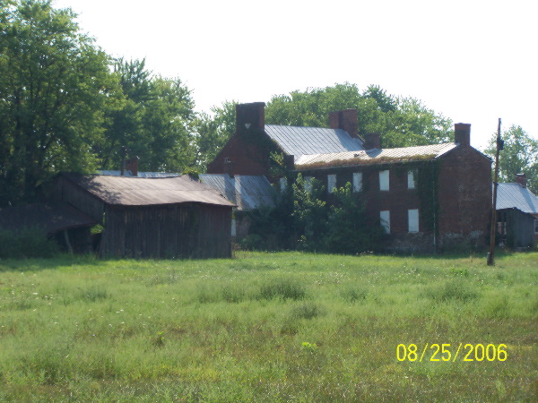
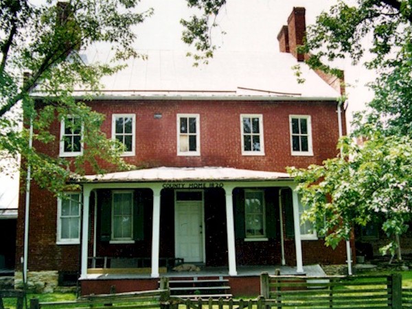
| Description | : | Bio: The Frederick County Poor Farm (sometimes known as the Poorhouse) on Poorhouse Road was built in 1820 and remained in operation into the 1900s. It was maintained by a charitable organization known as The Overseers of the Poor, which began operations in the county in 1793. The Poor Farm, as the name suggestions, was a home for the poor and insane persons of Frederick County, including the City of Winchester. In June of 1993 it was listed with the Virginia Landmarks Register (#034-0099) and in August of the same year with the National Register of Historic... Read More |
frequently asked questions (FAQ):
-
Where is Poor Farm Cemetery?
Poor Farm Cemetery is located at Poorhouse Road Round Hill, Frederick County ,Virginia ,USA.
-
Poor Farm Cemetery cemetery's updated grave count on graveviews.com?
10 memorials
-
Where are the coordinates of the Poor Farm Cemetery?
Latitude: 39.2123985
Longitude: -78.2233963
Nearby Cemetories:
1. Hodgson Cemetery
Round Hill, Frederick County, USA
Coordinate: 39.1963997, -78.2319031
2. Grange Hall Cemetery
Nain, Frederick County, USA
Coordinate: 39.2313995, -78.2241974
3. Rosedale Baptist Church Cemetery
Round Hill, Frederick County, USA
Coordinate: 39.1929016, -78.2219009
4. Round Hill United Methodist Church Cemetery
Round Hill, Frederick County, USA
Coordinate: 39.1942711, -78.2374115
5. Harper Graveyard
Round Hill, Frederick County, USA
Coordinate: 39.2076988, -78.2508163
6. Round Hill Presbyterian Church Cemetery
Round Hill, Frederick County, USA
Coordinate: 39.1899986, -78.2397003
7. Yeakley Cemetery
Frederick County, USA
Coordinate: 39.2416992, -78.2208023
8. Westminster-Canterbury Memorial Gardens
Frederick County, USA
Coordinate: 39.2021010, -78.1750927
9. Upper Ridge Cemetery
Nain, Frederick County, USA
Coordinate: 39.2346992, -78.1808014
10. Mount Olive United Methodist Church Cemetery
Hayfield, Frederick County, USA
Coordinate: 39.2261009, -78.2872009
11. White Graveyard
Hayfield, Frederick County, USA
Coordinate: 39.2279015, -78.2931976
12. Little Mountain United Methodist Church Cemetery
Cedar Grove, Frederick County, USA
Coordinate: 39.2728004, -78.1891022
13. Lamps Cemetery
Mount Williams, Frederick County, USA
Coordinate: 39.1740790, -78.2929980
14. Lamps Memorial Methodist Church Cemetery
Mount Pleasant, Frederick County, USA
Coordinate: 39.1725006, -78.2957993
15. Pritchard Family Cemetery
Kernstown, Frederick County, USA
Coordinate: 39.1452900, -78.1964100
16. Back Creek Quaker Cemetery
Gainesboro, Frederick County, USA
Coordinate: 39.2786100, -78.2569400
17. Old Opequon Cemetery
Kernstown, Frederick County, USA
Coordinate: 39.1393814, -78.1949387
18. Kern-Beemer Cemetery
Kernstown, Frederick County, USA
Coordinate: 39.1393585, -78.1934280
19. Pleasant Valley United Methodist Church Cemetery
Cedar Grove, Frederick County, USA
Coordinate: 39.2834015, -78.1800995
20. Welltown United Methodist Church Cemetery
Welltown, Frederick County, USA
Coordinate: 39.2532997, -78.1333008
21. Milburn Methodist Chapel Cemetery
Stephenson, Frederick County, USA
Coordinate: 39.2235985, -78.1136017
22. Galilee Christian Church Cemetery
Clear Brook, Frederick County, USA
Coordinate: 39.2640991, -78.1341019
23. Greenwood United Methodist Church Cemetery
Greenwood Heights, Frederick County, USA
Coordinate: 39.1719017, -78.1222000
24. Clowser Cemetery
Hayfield, Frederick County, USA
Coordinate: 39.1902906, -78.3351269