
| Memorials | : | 0 |
| Location | : | Monroe County, USA |
| Coordinate | : | 31.6145950, -87.2941930 |
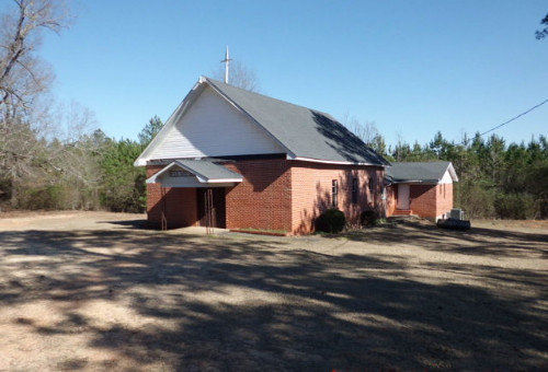
| Description | : | The Mt. Olive Baptist Church & Cemetery may be said as residing in community names such as Axle, Fountain, Ridge or Peterman. That, notwithstanding, the community is in the Peterman postal zone and is near the more established churches and cemeteries known as Ridge, Ridge #2, and Mars Hill. Directions: Leaving from the City of Monroeville, go to the old courthouse square. At the northwest corner of the square turn right onto Hwy-41 (toward the Claiborne Lock & Dam). At about 5.5 miles will be CR-42 (also known as The Ridge Road).... Read More |
frequently asked questions (FAQ):
-
Where is Mount Olive Baptist Church Cemetery?
Mount Olive Baptist Church Cemetery is located at 4815 Ridge Road Monroe County ,Alabama , 36471USA.
-
Mount Olive Baptist Church Cemetery cemetery's updated grave count on graveviews.com?
0 memorials
-
Where are the coordinates of the Mount Olive Baptist Church Cemetery?
Latitude: 31.6145950
Longitude: -87.2941930

Nearby Cemetories:
1. Mars Hill Baptist Church Cemetery
Peterman, Monroe County, USA
Coordinate: 31.5942320, -87.2849240
2. McWilliams-Davison Cemetery
Axle, Monroe County, USA
Coordinate: 31.5956440, -87.3279620
3. Amity Cemetery
Tunnel Springs, Monroe County, USA
Coordinate: 31.6394660, -87.2619360
4. Liberty Church Cemetery
Tunnel Springs, Monroe County, USA
Coordinate: 31.6360050, -87.2440810
5. Frye Cemetery
Axle, Monroe County, USA
Coordinate: 31.6180120, -87.3507500
6. Ridge Cemetery
Peterman, Monroe County, USA
Coordinate: 31.5967007, -87.3471985
7. Cunningham Cemetery
Tunnel Springs, Monroe County, USA
Coordinate: 31.6575090, -87.2601990
8. Old Scotland Presbyterian Church Cemetery
Monroeville, Monroe County, USA
Coordinate: 31.6673130, -87.2731460
9. Philadelphia Baptist Church Cemetery
Tunnel Springs, Monroe County, USA
Coordinate: 31.6480060, -87.2394500
10. Rumbley Cemetery
Monroeville, Monroe County, USA
Coordinate: 31.5718994, -87.2463989
11. Davidson Cemetery
Monroe County, USA
Coordinate: 31.6749992, -87.2891998
12. Davison-McMillan Cemetery
Tunnel Springs, Monroe County, USA
Coordinate: 31.6756630, -87.2869350
13. Ridge Cemetery #2
Monroe County, USA
Coordinate: 31.5944970, -87.3636620
14. Poindexter Cemetery
Peterman, Monroe County, USA
Coordinate: 31.5738500, -87.2314210
15. Palmer Abney Cemetery
Monroe County, USA
Coordinate: 31.5925680, -87.3740500
16. Limestone Missionary Baptist Church Cemetery
Monroe County, USA
Coordinate: 31.5503900, -87.3322200
17. Davis Family Cemetery
Monroe County, USA
Coordinate: 31.5919940, -87.2112360
18. Fountain Cemetery
Tunnel Springs, Monroe County, USA
Coordinate: 31.6588600, -87.2219260
19. Rankin Cemetery
Monroe County, USA
Coordinate: 31.5763300, -87.2087900
20. Daniel Baptist Church Cemetery
Monroeville, Monroe County, USA
Coordinate: 31.5347760, -87.2588660
21. Pineville Cemetery
Monroeville, Monroe County, USA
Coordinate: 31.5302930, -87.3187190
22. Hillcrest Cemetery
Monroeville, Monroe County, USA
Coordinate: 31.5300370, -87.3175070
23. Baptist Cemetery
Monroeville, Monroe County, USA
Coordinate: 31.5300700, -87.3187100
24. Old Limestone Baptist Cemetery
Monroeton, Monroe County, USA
Coordinate: 31.5348330, -87.2478330