
| Memorials | : | 3 |
| Location | : | Harrods Creek, Jefferson County, USA |
| Phone | : | (502) 228-1176 |
| Coordinate | : | 38.3210520, -85.6248870 |
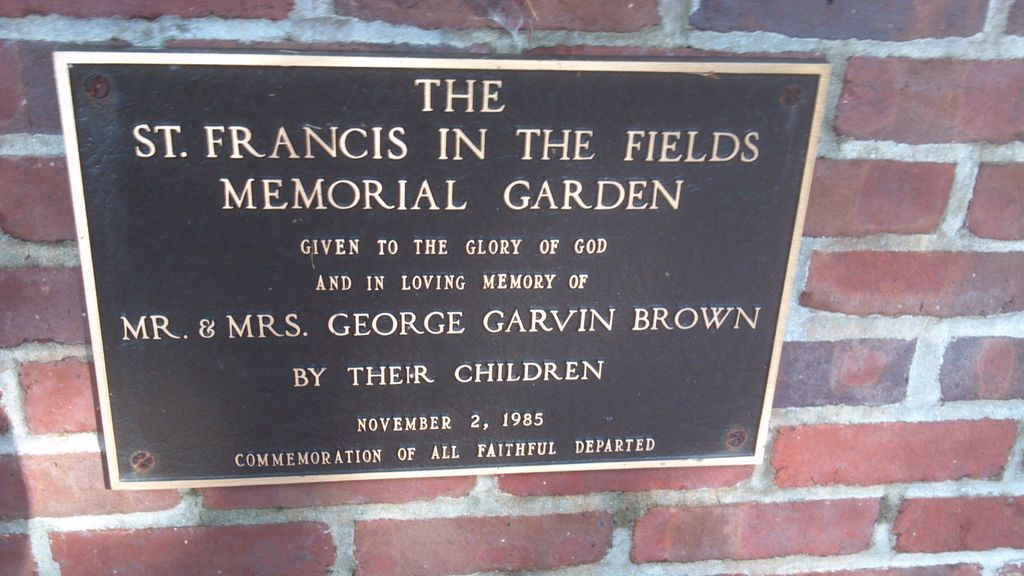
| Description | : | 6710 Wolf Pen Branch Road, Harrods Creek, KY 40027 (502) 228-1176 Directions St. Francis in the Fields Episcopal Church is located at the corner of Wolf Pen Branch Road and U.S. Highway 42 in Harrods Creek, Kentucky. Harrods Creek is situated northeast of Louisville, close to the city of Prospect. |
frequently asked questions (FAQ):
-
Where is Saint Francis in the Fields Memorial Garden?
Saint Francis in the Fields Memorial Garden is located at 6710 Wolf Pen Branch Road Harrods Creek, Jefferson County ,Kentucky , 40027USA.
-
Saint Francis in the Fields Memorial Garden cemetery's updated grave count on graveviews.com?
3 memorials
-
Where are the coordinates of the Saint Francis in the Fields Memorial Garden?
Latitude: 38.3210520
Longitude: -85.6248870
Nearby Cemetories:
1. Hillcrest Cemetery
Utica, Clark County, USA
Coordinate: 38.3391991, -85.6514969
2. Berry Hill Cemetery
Louisville, Jefferson County, USA
Coordinate: 38.2943910, -85.6404680
3. Steele Cemetery
Goshen, Oldham County, USA
Coordinate: 38.3370560, -85.5886940
4. Lentz Heirs Cemetery
Utica, Clark County, USA
Coordinate: 38.3510017, -85.6511002
5. Lentz Family Cemetery
Utica, Clark County, USA
Coordinate: 38.3513780, -85.6510770
6. Murray-Young Cemetery
Lyndon, Jefferson County, USA
Coordinate: 38.2901887, -85.5873743
7. Smith Family Cemetery
Utica, Clark County, USA
Coordinate: 38.3389000, -85.6764000
8. Burtt Cemetery
Utica, Clark County, USA
Coordinate: 38.3496017, -85.6719971
9. Herr Cemetery #3
Louisville, Jefferson County, USA
Coordinate: 38.2756430, -85.6391020
10. Christ Church United Methodist Memorial Garden
Louisville, Jefferson County, USA
Coordinate: 38.2740750, -85.6446790
11. Barbour-Ewing Cemetery
River Bluff, Oldham County, USA
Coordinate: 38.3491940, -85.5716940
12. Adams Family Cemetery (Defunct)
Jeffersonville, Clark County, USA
Coordinate: 38.3150300, -85.6887200
13. Taylor Cemetery
Brownsboro, Oldham County, USA
Coordinate: 38.3399730, -85.5629830
14. Saint Thomas Episcopal Church Meditation Garden
Jefferson County, USA
Coordinate: 38.2861100, -85.5743700
15. Hardin Cemetery #2
Oldham County, USA
Coordinate: 38.3610840, -85.5750440
16. Locke Cemetery
Pewee Valley, Oldham County, USA
Coordinate: 38.3684850, -85.5857280
17. Koonz Cemetery (Defunct)
Charlestown, Clark County, USA
Coordinate: 38.3710000, -85.6637000
18. Espy Cemetery
Clark County, USA
Coordinate: 38.3276863, -85.7010498
19. New Chapel United Methodist Church Cemetery
Watson, Clark County, USA
Coordinate: 38.3546982, -85.6893005
20. Queen of Heaven Cemetery
Jeffersonville, Clark County, USA
Coordinate: 38.3543450, -85.6934020
21. Dailey Cemetery
Utica Township, Clark County, USA
Coordinate: 38.3824950, -85.6457370
22. Ormsby Graveyard
Lyndon, Jefferson County, USA
Coordinate: 38.2653600, -85.5800600
23. Ballardsville Church Cemetery
Louisville, Jefferson County, USA
Coordinate: 38.3129040, -85.5404710
24. Barbour Cemetery #1
Pewee Valley, Oldham County, USA
Coordinate: 38.3840280, -85.5947220