
| Memorials | : | 354 |
| Location | : | Cliviger, Burnley Borough, England |
| Coordinate | : | 53.7533610, -2.1895090 |
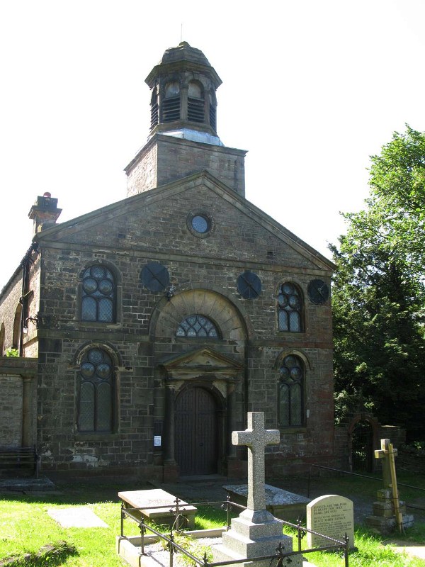
| Description | : | St. John the Divine Church The chapel at HOLME was probably built in the time of Henry VIII,and at the Reformation fell into disuse,being considered the property of the Whitaker family. What endowment had belonged to it was confiscated by Edward VI and the chapel remained without a minister, except under the Commonwealth, for nearly 200 years, though about 1717 Bishop Gastrell recorded that the curate of Burnley preached there once a quarter. A curate was licensed in 1742 and by the gifts of various benefactors, including Dr. Whitaker, the historian,sometime incumbent of this family chapel, an endowment was provided,... Read More |
frequently asked questions (FAQ):
-
Where is St. John the Divine Churchyard?
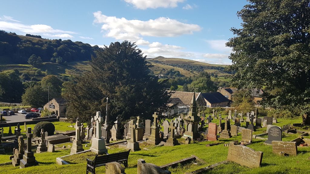
St. John the Divine Churchyard is located at Burnley Road Cliviger, Burnley Borough ,Lancashire , BB10 4SUEngland.
-
St. John the Divine Churchyard cemetery's updated grave count on graveviews.com?
353 memorials
-
Where are the coordinates of the St. John the Divine Churchyard?
Latitude: 53.7533610
Longitude: -2.1895090
Nearby Cemetories:
1. Mount Zion Methodist Chapleyard
Cornholme, Metropolitan Borough of Calderdale, England
Coordinate: 53.7331400, -2.1457800
2. St. John the Evangelist Churchyard
Worsthorne, Burnley Borough, England
Coordinate: 53.7877640, -2.1887420
3. Vale Baptist Chapelyard
Cornholme, Metropolitan Borough of Calderdale, England
Coordinate: 53.7321800, -2.1357300
4. Shore Baptist Chapelyard
Cornholme, Metropolitan Borough of Calderdale, England
Coordinate: 53.7358900, -2.1312700
5. Lumb Baptist Church Cemetery
Waterfoot, Rossendale Borough, England
Coordinate: 53.7229340, -2.2455170
6. Saint Michael on the Hill Churchyard
Lumb, Rossendale Borough, England
Coordinate: 53.7201000, -2.2479300
7. St. Peter's Churchyard
Burnley, Burnley Borough, England
Coordinate: 53.7924450, -2.2394890
8. Ebenezer Particular Baptist Chapel Chapelyard
Bacup, Rossendale Borough, England
Coordinate: 53.7045700, -2.1997500
9. St. James' Churchyard
Burnley, Burnley Borough, England
Coordinate: 53.7905590, -2.2458280
10. St John the Evangelist Churchyard
Bacup, Rossendale Borough, England
Coordinate: 53.7037300, -2.2019600
11. Cloughfoot Independent Congregational Chapelyard
Todmorden, Metropolitan Borough of Calderdale, England
Coordinate: 53.7113850, -2.1379180
12. Ebenezer Baptist Chapel Chapelyard
Burnley, Burnley Borough, England
Coordinate: 53.7975120, -2.2397260
13. Holy Trinity Churchyard
Burnley, Burnley Borough, England
Coordinate: 53.7898290, -2.2574200
14. Providence Free United Methodist Graveyard
Crawshawbooth, Rossendale Borough, England
Coordinate: 53.7442070, -2.2825700
15. St. James' Churchyard
Briercliffe, Burnley Borough, England
Coordinate: 53.8107700, -2.2031800
16. Goodshaw Particular Baptist Chapel Graveyard
Goodshaw, Rossendale Borough, England
Coordinate: 53.7328210, -2.2815530
17. St. Mary and All Saints Churchyard
Goodshaw, Rossendale Borough, England
Coordinate: 53.7315270, -2.2828940
18. Burnley Cemetery
Burnley, Burnley Borough, England
Coordinate: 53.7821730, -2.2795070
19. Burnley Crematorium
Burnley, Burnley Borough, England
Coordinate: 53.7821730, -2.2795070
20. Saint Anne's Churchyard Edgeside
Waterfoot, Rossendale Borough, England
Coordinate: 53.7031600, -2.2482700
21. Haggate Baptist Church Burial Ground
Burnley Borough, England
Coordinate: 53.8145048, -2.1960725
22. Hill Lane Baptist Church Churchyard
Briercliffe, Burnley Borough, England
Coordinate: 53.8161467, -2.1875368
23. Rehoboth Chapel
Goodshaw, Rossendale Borough, England
Coordinate: 53.7355870, -2.2914730
24. Mount Pleasant Wesleyan Chapelyard
Bacup, Rossendale Borough, England
Coordinate: 53.6924900, -2.2228100