
| Memorials | : | 2 |
| Location | : | Menlo Park, San Mateo County, USA |
| Coordinate | : | 37.4595050, -122.1680330 |
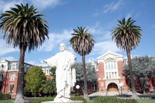
| Description | : | Located between Atherton and Stanford University, Saint Patrrick's Seminary was established in 1894; through the efforts of then Archbishop Patrick William Riordan (1848-1958) and many wealthy benefactors, to include Mrs. Rupert Johnson and Mrs. Leland Stanford. By 1902, the status of major seminary and collegiate institution were achieved. St. Patrick's Seminary Chapel has been the heart and center of seminary life for over 100 years. It occupies the architectural center of the seminary complex. The crypt of the chapel was completed and dedicated, by Coadjutor Archbishop George Montgomery, on August 4, 1904. Following the complete devastation of the chapel, during the... Read More |
frequently asked questions (FAQ):
-
Where is Saint Patricks Seminary Chapel Crypt?
Saint Patricks Seminary Chapel Crypt is located at 320 Middlefield Road Menlo Park, San Mateo County ,California , 94025USA.
-
Saint Patricks Seminary Chapel Crypt cemetery's updated grave count on graveviews.com?
2 memorials
-
Where are the coordinates of the Saint Patricks Seminary Chapel Crypt?
Latitude: 37.4595050
Longitude: -122.1680330
Nearby Cemetories:
1. Trinity Episcopal Church Memorial Garden
Menlo Park, San Mateo County, USA
Coordinate: 37.4562300, -122.1789300
2. Corpus Christi Monastery
Menlo Park, San Mateo County, USA
Coordinate: 37.4589200, -122.1801900
3. First United Methodist Church Memorial Garden
Palo Alto, Santa Clara County, USA
Coordinate: 37.4493870, -122.1568630
4. All Saints Episcopal Church Memorial Garden
Palo Alto, Santa Clara County, USA
Coordinate: 37.4466933, -122.1592525
5. Stanford Family Mausoleum
Palo Alto, Santa Clara County, USA
Coordinate: 37.4364929, -122.1698990
6. Oakwood Community Cemetery
Atherton, San Mateo County, USA
Coordinate: 37.4503120, -122.1956310
7. Holy Cross Catholic Cemetery
Menlo Park, San Mateo County, USA
Coordinate: 37.4350420, -122.1978540
8. Saint Marks Episcopal Church All Souls Garden
Palo Alto, Santa Clara County, USA
Coordinate: 37.4318900, -122.1299000
9. Union Cemetery
Redwood City, San Mateo County, USA
Coordinate: 37.4732700, -122.2231360
10. Saint Bedes Episcopal Church Cemetery
Menlo Park, San Mateo County, USA
Coordinate: 37.4218750, -122.2075210
11. Dennis Martin Cemetery
San Mateo County, USA
Coordinate: 37.4203440, -122.2181370
12. Saint Peters Episcopal Church Columbarium
Redwood City, San Mateo County, USA
Coordinate: 37.4855750, -122.2389540
13. Alta Mesa Memorial Park
Palo Alto, Santa Clara County, USA
Coordinate: 37.3990200, -122.1288300
14. Mathias Alfred Parkhurst Burial Site
Woodside, San Mateo County, USA
Coordinate: 37.4306710, -122.2770660
15. Christ Episcopal Church Churchyard Columbarium
Portola Valley, San Mateo County, USA
Coordinate: 37.3821670, -122.2304160
16. Mountain View Buddhist Church
Mountain View, Santa Clara County, USA
Coordinate: 37.4020680, -122.0774160
17. Mountain View Cemetery
Mountain View, Santa Clara County, USA
Coordinate: 37.3894600, -122.0834300
18. Christ Episcopal Church Columbarium
Los Altos, Santa Clara County, USA
Coordinate: 37.3642210, -122.1044590
19. Gorilla Foundation Sanctuary
Woodside, San Mateo County, USA
Coordinate: 37.3750160, -122.2604360
20. Saint Timothy's Episcopal Church Columbarium
Mountain View, Santa Clara County, USA
Coordinate: 37.3725650, -122.0782480
21. Bourn Family Cemetery
Woodside, San Mateo County, USA
Coordinate: 37.4676100, -122.3124400
22. Episcopal Church of Transfiguration Memorial Garde
San Mateo, San Mateo County, USA
Coordinate: 37.5273480, -122.3058880
23. Saint Thomas Episcopal Church Columbarium
Sunnyvale, Santa Clara County, USA
Coordinate: 37.3773110, -122.0432030
24. Harrington Cemetery
Belmont, San Mateo County, USA
Coordinate: 37.5032997, -122.3238983