
| Memorials | : | 0 |
| Location | : | Franklin, Monroe County, USA |
| Coordinate | : | 31.7128720, -87.3924870 |
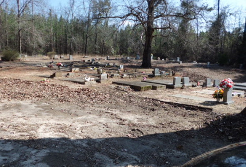
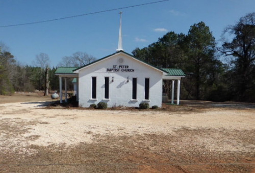
| Description | : | The St Peter Baptist Church is an African-American church and cemetery in the community of Franklin. The church is located near the Franklin water tower on Tin Cup Alley Road and is about 100 yards east at the rear of the church. In the near vicinity is the Springhill First Baptist Church and cemetery, as well as the River Ridge Cemetery on River Ridge Road. The grounds around the church are well maintained and there is ample parking at both the church and the cemetery. The cemetery lies on a hillside beneath a stand of giant... Read More |
frequently asked questions (FAQ):
-
Where is Saint Peter Baptist Church Cemetery?
Saint Peter Baptist Church Cemetery is located at Franklin, Monroe County ,Alabama ,USA.
-
Saint Peter Baptist Church Cemetery cemetery's updated grave count on graveviews.com?
0 memorials
-
Where are the coordinates of the Saint Peter Baptist Church Cemetery?
Latitude: 31.7128720
Longitude: -87.3924870
Nearby Cemetories:
1. York Cemetery
Monroe County, USA
Coordinate: 31.7250004, -87.3897018
2. River Ridge Cemetery
Franklin, Monroe County, USA
Coordinate: 31.7251470, -87.3897660
3. Springhill First Baptist Church Cemetery
Franklin, Monroe County, USA
Coordinate: 31.6932190, -87.3952440
4. Red Hills Cemetery
Franklin, Monroe County, USA
Coordinate: 31.7326860, -87.3465070
5. Johnson-McDuffie Cemetery
Franklin, Monroe County, USA
Coordinate: 31.7479900, -87.4259500
6. Carr Cemetery
River Ridge, Monroe County, USA
Coordinate: 31.7657080, -87.3520520
7. Corinth-Deer Cemetery
Franklin, Monroe County, USA
Coordinate: 31.6491670, -87.4012540
8. Bryant-Deer Cemetery
Monroe County, USA
Coordinate: 31.6488991, -87.4013977
9. Mount Ararat Cemetery
Monroe County, USA
Coordinate: 31.6449300, -87.4054900
10. Powell Cemetery
Packards Bend, Monroe County, USA
Coordinate: 31.7581005, -87.4617004
11. Morrissette Family Cemetery
Packards Bend, Monroe County, USA
Coordinate: 31.7720500, -87.4610000
12. York Chapel AME Church Cemetery
Finchburg, Monroe County, USA
Coordinate: 31.6305510, -87.4264434
13. Bell Cemetery
Vredenburgh, Monroe County, USA
Coordinate: 31.7791400, -87.3150450
14. Bells Landing Cemetery
Hybart, Monroe County, USA
Coordinate: 31.8079970, -87.3973410
15. Davidson Cemetery
Monroe County, USA
Coordinate: 31.6749992, -87.2891998
16. Davison-McMillan Cemetery
Tunnel Springs, Monroe County, USA
Coordinate: 31.6756630, -87.2869350
17. Bryant Cemetery
Finchburg, Monroe County, USA
Coordinate: 31.6275005, -87.4480972
18. Shiloh Baptist Church Cemetery
Natchez, Monroe County, USA
Coordinate: 31.7200670, -87.2763680
19. Eureka Baptist Church Cemetery
Finchburg, Monroe County, USA
Coordinate: 31.6356130, -87.4657830
20. Independent Baptist Church Cemetery
Packards Bend, Monroe County, USA
Coordinate: 31.7736740, -87.4867700
21. Hybart Cemetery
Monroe County, USA
Coordinate: 31.8132992, -87.3846970
22. Frye Cemetery
Axle, Monroe County, USA
Coordinate: 31.6180120, -87.3507500
23. Pilgrim Rest Baptist Church Cemetery
Wainwright, Monroe County, USA
Coordinate: 31.6491880, -87.4854940
24. Mount Sinai A.M.E. Church Cemetery
Lower Peach Tree, Wilcox County, USA
Coordinate: 31.7693550, -87.4942630