
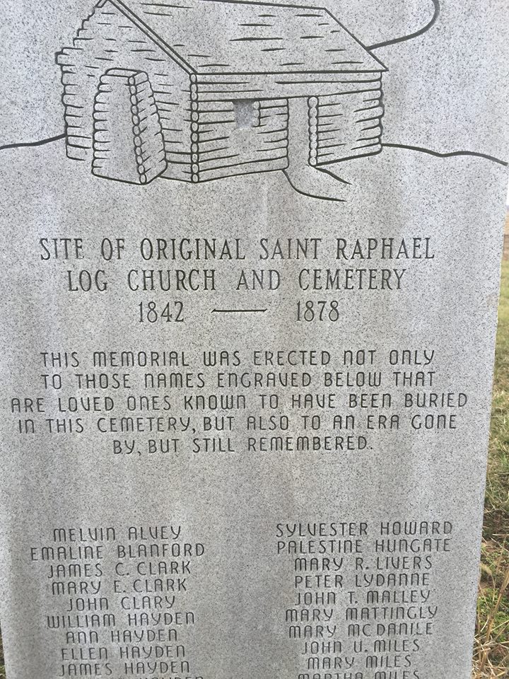
| Memorials | : | 0 |
| Location | : | West Louisville, Daviess County, USA |
| Coordinate | : | 37.7009600, -87.2442900 |
frequently asked questions (FAQ):
-
Where is Saint Raphael Original Log Church and Cemetery?
Saint Raphael Original Log Church and Cemetery is located at West Louisville, Daviess County ,Kentucky ,USA.
-
Saint Raphael Original Log Church and Cemetery cemetery's updated grave count on graveviews.com?
0 memorials
-
Where are the coordinates of the Saint Raphael Original Log Church and Cemetery?
Latitude: 37.7009600
Longitude: -87.2442900
Nearby Cemetories:
1. Saint Raphael Cemetery
West Louisville, Daviess County, USA
Coordinate: 37.7033900, -87.2489000
2. Mount Zion Methodist Episcopal Church Cemetery
Panther, Daviess County, USA
Coordinate: 37.6638700, -87.2325500
3. Hitchcock Family Cemetery
Sorgho, Daviess County, USA
Coordinate: 37.7423261, -87.2686245
4. Saint Mary Magdalene Catholic Cemetery
Sorgho, Daviess County, USA
Coordinate: 37.7503050, -87.2487870
5. Atheys Chapel Cemetery
Rome, Daviess County, USA
Coordinate: 37.7227800, -87.1815980
6. Sorgho Baptist Church Cemetery
Sorgho, Daviess County, USA
Coordinate: 37.7552700, -87.2588600
7. Murphy Grave
Panther, Daviess County, USA
Coordinate: 37.6469530, -87.2270990
8. Little Flock Baptist Cemetery
Sorgho, Daviess County, USA
Coordinate: 37.7573600, -87.2687700
9. Nickel Ridge Cemetery
Panther, Daviess County, USA
Coordinate: 37.6505400, -87.2037100
10. Old Macedonia Cemetery
Daviess County, USA
Coordinate: 37.6489000, -87.2822000
11. Crabtree Cemetery
Sorgho, Daviess County, USA
Coordinate: 37.7560000, -87.2120000
12. Mount Saint Joseph Cemetery
Maple Mount, Daviess County, USA
Coordinate: 37.6931000, -87.3216570
13. Calhoon Curdsville Cemetery
Curdsville, Daviess County, USA
Coordinate: 37.7440000, -87.3020000
14. Pleasant Grove Baptist Church Cemetery
Sorgho, Daviess County, USA
Coordinate: 37.7552300, -87.2037700
15. Brushy Fork Cemetery
Panther, Daviess County, USA
Coordinate: 37.6375999, -87.2545013
16. Saint Alphonsus Cemetery
Saint Joseph, Daviess County, USA
Coordinate: 37.6948800, -87.3247700
17. Short Family Cemetery
Panther, Daviess County, USA
Coordinate: 37.6387040, -87.2234630
18. Old Macedonia Cemetery
Panther, Daviess County, USA
Coordinate: 37.6530000, -87.3042000
19. Little Flock Cemetery
West Louisville, Daviess County, USA
Coordinate: 37.6369900, -87.2733300
20. Harold Cemetery
Sorgho, Daviess County, USA
Coordinate: 37.7473602, -87.1791942
21. Barbour Cemetery
Owensboro, Daviess County, USA
Coordinate: 37.7485000, -87.1730160
22. Dabney C Robertson Family Graveyard
Daviess County, USA
Coordinate: 37.6256720, -87.2453760
23. Welden Cemetery
Hebbardsville, Henderson County, USA
Coordinate: 37.7503200, -87.3253800
24. Sands Cemetery
Daviess County, USA
Coordinate: 37.7651960, -87.1794200