
| Memorials | : | 0 |
| Location | : | Manhattan, New York County (Manhattan), USA |
| Coordinate | : | 40.7187830, -73.9933450 |
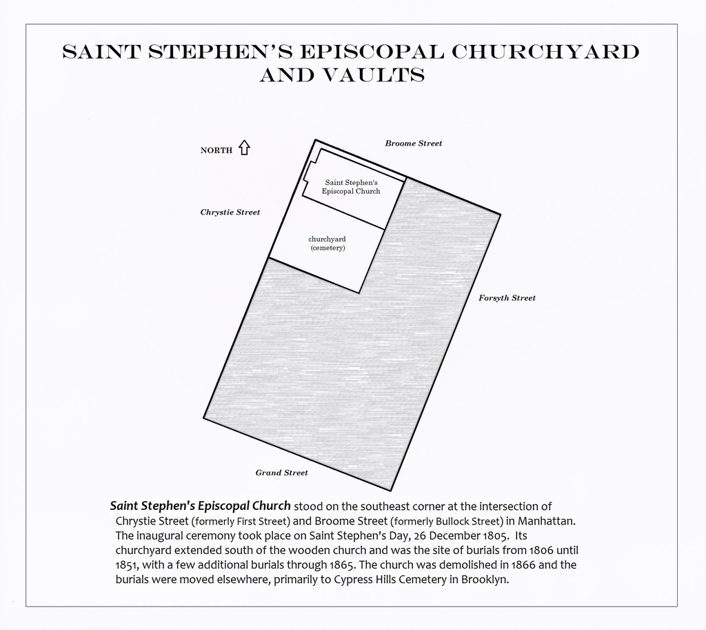
| Description | : | The inaugural ceremony of Saint Stephen's Church took place on Saint Stephen's Day, 26 December 1805. Situated on the southeast corner of what are now Broome Street and Chrystie Street, Saint Stephen's was the fifth Episcopal parish in the Diocese of New York. Its primary burial ground was the churchyard which extended south of the church. The original church was a wooden structure with a steeple. It was demolished in 1866. The site is now a part of Sara Delano Roosevelt Park, which cuts off Broome Street along the north end of the former churchyard. The Saint Stephen's congregation eventually merged with... Read More |
frequently asked questions (FAQ):
-
Where is Saint Stephen's Episcopal Churchyard and Vaults?
Saint Stephen's Episcopal Churchyard and Vaults is located at Chrystie Street and Broome Street Manhattan, New York County (Manhattan) ,New York ,USA.
-
Saint Stephen's Episcopal Churchyard and Vaults cemetery's updated grave count on graveviews.com?
0 memorials
-
Where are the coordinates of the Saint Stephen's Episcopal Churchyard and Vaults?
Latitude: 40.7187830
Longitude: -73.9933450
Nearby Cemetories:
1. Bethel Baptist Churchyard and Burial Vaults
Manhattan, New York County (Manhattan), USA
Coordinate: 40.7202630, -73.9923950
2. Methodist Society Cemetery
New York, New York County (Manhattan), USA
Coordinate: 40.7164260, -73.9945290
3. Allen Street Methodist Burial Ground
Manhattan, New York County (Manhattan), USA
Coordinate: 40.7197850, -73.9897370
4. German Reformed Cemetery
Manhattan, New York County (Manhattan), USA
Coordinate: 40.7152800, -73.9947050
5. Forsyth Street Methodist Episcopal Churchyard
New York County (Manhattan), USA
Coordinate: 40.7148070, -73.9942650
6. Dutch Reformed Church Cemetery
Manhattan, New York County (Manhattan), USA
Coordinate: 40.7225500, -73.9908800
7. Presbyterian Cemetery
Manhattan, New York County (Manhattan), USA
Coordinate: 40.7228400, -73.9910700
8. Houston Street Cemetery
New York, New York County (Manhattan), USA
Coordinate: 40.7234200, -73.9919210
9. Saint Patrick's Old Cathedral Churchyard
Manhattan, New York County (Manhattan), USA
Coordinate: 40.7239800, -73.9949100
10. First Moravian Church Fresh Water Burial Ground
Manhattan, New York County (Manhattan), USA
Coordinate: 40.7151210, -73.9985380
11. First Baptist Cemetery (Defunct)
Manhattan, New York County (Manhattan), USA
Coordinate: 40.7235040, -73.9897220
12. Methodist Protestant Attorney Street Vaults
New York County (Manhattan), USA
Coordinate: 40.7182010, -73.9848410
13. New York City Marble Cemetery
Manhattan, New York County (Manhattan), USA
Coordinate: 40.7245190, -73.9891060
14. Second Presbyterian Cemetery
Manhattan, New York County (Manhattan), USA
Coordinate: 40.7212450, -74.0015860
15. Oliver Street Baptist Churchyard
Manhattan, New York County (Manhattan), USA
Coordinate: 40.7128470, -73.9977730
16. New York Marble Cemetery
Manhattan, New York County (Manhattan), USA
Coordinate: 40.7252570, -73.9903050
17. First Cemetery of Congregation Shearith Israel
Chinatown, New York County (Manhattan), USA
Coordinate: 40.7129211, -73.9985352
18. Bleecker Street Presbyterian Church
New York, New York County (Manhattan), USA
Coordinate: 40.7263090, -73.9950690
19. Most Holy Redeemer Church Vault
Manhattan, New York County (Manhattan), USA
Coordinate: 40.7234690, -73.9844930
20. Second African Burial Ground
Manhattan, New York County (Manhattan), USA
Coordinate: 40.7144400, -74.0047200
21. African Burial Ground National Monument
New York, New York County (Manhattan), USA
Coordinate: 40.7144400, -74.0047200
22. Duane Street Methodist Church Cemetery
New York, New York County (Manhattan), USA
Coordinate: 40.7171050, -74.0092460
23. Old Brick Presbyterian Church Cemetery
Manhattan, New York County (Manhattan), USA
Coordinate: 40.7116340, -74.0064030
24. Saint Marks Church-In-The-Bowery Churchyard
Manhattan, New York County (Manhattan), USA
Coordinate: 40.7302800, -73.9871300