| Memorials | : | 4 |
| Location | : | Trenton, Henry County, USA |
| Coordinate | : | 41.0539030, -91.6921730 |
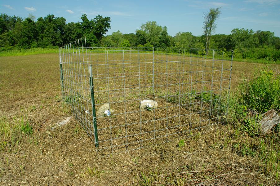
| Description | : | Scheffel Family Burials is a small inactive Pioneer Cemetery located in section 8 of Trenton Township. Going South from 170th Street approximately one half mile on White Oak Road. It is in the middle of a field on private property approximately one fourth mile west of White Oak Road. The landowner has erected a fence around the small plot. There are four know burials but only two stones remain and of these only one is readable. Please check with the landowner if you wish to visit this cemetery. |
frequently asked questions (FAQ):
-
Where is Scheffel Family Cemetery?
Scheffel Family Cemetery is located at Trenton, Henry County ,Iowa ,USA.
-
Scheffel Family Cemetery cemetery's updated grave count on graveviews.com?
4 memorials
-
Where are the coordinates of the Scheffel Family Cemetery?
Latitude: 41.0539030
Longitude: -91.6921730
Nearby Cemetories:
1. Roth Cemetery
Trenton, Henry County, USA
Coordinate: 41.0515000, -91.6772000
2. Messer Cemetery
Henry County, USA
Coordinate: 41.0419006, -91.6885986
3. Green Mound Cemetery
Henry County, USA
Coordinate: 41.0696983, -91.6652985
4. White Oak Cemetery
Trenton, Henry County, USA
Coordinate: 41.0293999, -91.6793976
5. Alfred Warner Family Burial Ground
Trenton, Henry County, USA
Coordinate: 41.0180520, -91.6909500
6. Vorhies Cemetery
Rome, Henry County, USA
Coordinate: 41.0213230, -91.7134810
7. Four Corners German Lutheran Cemetery
Lockridge, Jefferson County, USA
Coordinate: 41.0247002, -91.7605972
8. Hope Lutheran Cemetery
Germanville, Jefferson County, USA
Coordinate: 41.0943985, -91.7593994
9. Dallner Cemetery
Jefferson County, USA
Coordinate: 41.1047000, -91.7458000
10. Finley Cemetery
Henry County, USA
Coordinate: 41.0913800, -91.6202800
11. Grant Cemetery
Rome, Henry County, USA
Coordinate: 40.9880981, -91.6992035
12. Union Free Cemetery
Germanville, Jefferson County, USA
Coordinate: 41.0971000, -91.7585000
13. New Richwoods Cemetery
Trenton, Henry County, USA
Coordinate: 41.0270000, -91.6118000
14. New Sweden United Methodist Church Cemetery
Lockridge, Jefferson County, USA
Coordinate: 41.0247002, -91.7752991
15. Hopkirk Cemetery
Jefferson County, USA
Coordinate: 41.0029000, -91.7566000
16. Hopkirk Family Cemetery
Lockridge, Jefferson County, USA
Coordinate: 40.9928820, -91.7396530
17. Richwoods South Cemetery
Henry County, USA
Coordinate: 41.0177000, -91.6115000
18. New Sweden Lutheran Cemetery
Lockridge, Jefferson County, USA
Coordinate: 41.0238991, -91.7797012
19. Nelson Plot
Jefferson County, USA
Coordinate: 41.1243890, -91.7185420
20. Old Baptist Cemetery
Wayland, Henry County, USA
Coordinate: 41.1045000, -91.6209000
21. Lockridge Cemetery
Lockridge, Jefferson County, USA
Coordinate: 40.9952000, -91.7558500
22. Traxler Cemetery
Mount Pleasant, Henry County, USA
Coordinate: 41.0413500, -91.5922000
23. New Sweden Baptist Cemetery
Jefferson County, USA
Coordinate: 41.0242004, -91.7857971
24. Smith Family Burial Site
Mount Pleasant, Henry County, USA
Coordinate: 40.9755300, -91.6987500


