
| Memorials | : | 0 |
| Location | : | Lowgap, Surry County, USA |
| Coordinate | : | 36.5333640, -80.8758540 |
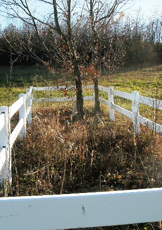
| Description | : | Location: Corner of W. Pine St (NC Hwy 89) and Boyd Dickens Rd (SR 1433), Low Gap, Surry Co., NC. Directions: From the intersection of US Highway 52 N and W. Pine St in Mount Airy, go west on W. Pine St to the intersection of W. Pine Street and Boyd Dickens Rd in Low Gap, NC. The cemetery is on the southwest corner and is surrounded by a white vinyl fence. |
frequently asked questions (FAQ):
-
Where is Shinault Family Cemetery?
Shinault Family Cemetery is located at Lowgap, Surry County ,North Carolina ,USA.
-
Shinault Family Cemetery cemetery's updated grave count on graveviews.com?
0 memorials
-
Where are the coordinates of the Shinault Family Cemetery?
Latitude: 36.5333640
Longitude: -80.8758540
Nearby Cemetories:
1. Galyean Family Cemetery
Lowgap, Surry County, USA
Coordinate: 36.5346140, -80.8703660
2. Liberty Union Baptist Cemetery
Lowgap, Surry County, USA
Coordinate: 36.5273056, -80.8688583
3. Fishers Gap Church Cemetery
Lowgap, Surry County, USA
Coordinate: 36.5231400, -80.8833923
4. Mountain View Baptist Church Cemetery
Lowgap, Surry County, USA
Coordinate: 36.5197420, -80.8645570
5. Cockerham Family Cemetery
Lowgap, Surry County, USA
Coordinate: 36.5284720, -80.8465830
6. Roaring Gap Baptist Church Cemetery
Lowgap, Surry County, USA
Coordinate: 36.5101929, -80.8920288
7. Cumberland Knob Cemetery
Surry County, USA
Coordinate: 36.5535100, -80.9073400
8. Barker Graveyard
Lowgap, Surry County, USA
Coordinate: 36.5295540, -80.8340600
9. Smith Family Cemetery
Grayson County, USA
Coordinate: 36.5701930, -80.8726180
10. Goodson Cemetery
Grayson County, USA
Coordinate: 36.5688900, -80.8611200
11. Montgomery Cemetery
Surry County, USA
Coordinate: 36.5439722, -80.8204722
12. Fairview Memorial Gardens
Low Gap, Grayson County, USA
Coordinate: 36.5784080, -80.9056970
13. Jarrell Family Cemetery
Lowgap, Surry County, USA
Coordinate: 36.5427860, -80.8103660
14. Snow Hill Baptist Church Cemetery
Low Gap, Grayson County, USA
Coordinate: 36.5859100, -80.8890390
15. Mount Vernon Baptist Church Cemetery
Beulah, Surry County, USA
Coordinate: 36.5003624, -80.8213882
16. Haven of Rest Bible Church Cemetery
Grayson County, USA
Coordinate: 36.5740400, -80.9222210
17. Saddle Mountain Baptist Church Cemetery
Ennice, Alleghany County, USA
Coordinate: 36.5082300, -80.9386300
18. Big Springs Regular Baptist Church Cemetery
Delhart, Grayson County, USA
Coordinate: 36.5710090, -80.9352570
19. Edmonds Cemetery
Edmonds, Alleghany County, USA
Coordinate: 36.5593310, -80.9457070
20. Ladonia Baptist Church Cemetery
Ladonia, Surry County, USA
Coordinate: 36.4780280, -80.8386670
21. Dillard Family Cemetery
Lowgap, Surry County, USA
Coordinate: 36.5500298, -80.8002243
22. Glades Memorial Cemetery
Grayson County, USA
Coordinate: 36.5887280, -80.9134430
23. Low Family Cemetery
Lowgap, Surry County, USA
Coordinate: 36.5461430, -80.7985910
24. Kirby-Poole Cemetery
Galax, Galax City, USA
Coordinate: 36.5711200, -80.9461100