| Memorials | : | 0 |
| Location | : | Shipston-on-Stour, Stratford-on-Avon District, England |
| Coordinate | : | 52.0629460, -1.6232670 |
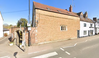
| Description | : | Friends began to meet in Shipston-on-Stour during the seventeenth century. The meeting house was built in 1690-2, extended in 1887/8 for a schoolroom and again in the mid-1990s to the east. The burial ground lies to the east of the meeting house. It is enclosed by brick walls and the date range of the burials is not known. Six round-headed headstones were relocated to the edge of the garden to the east. The burial ground is now maintained as a garden for the library and incorporates areas of planting. |
frequently asked questions (FAQ):
-
Where is Shipston-on-Stour Friends Burial Ground?
Shipston-on-Stour Friends Burial Ground is located at Church Street Shipston-on-Stour, Stratford-on-Avon District ,Warwickshire ,England.
-
Shipston-on-Stour Friends Burial Ground cemetery's updated grave count on graveviews.com?
0 memorials
-
Where are the coordinates of the Shipston-on-Stour Friends Burial Ground?
Latitude: 52.0629460
Longitude: -1.6232670
Nearby Cemetories:
1. Saint Martin's Churchyard
Barcheston, Stratford-on-Avon District, England
Coordinate: 52.0570290, -1.6149230
2. Shipston Cemetery
Shipston-on-Stour, Stratford-on-Avon District, England
Coordinate: 52.0534039, -1.6225776
3. All Saints Churchyard
Honington, Stratford-on-Avon District, England
Coordinate: 52.0818000, -1.6200000
4. St Barnabas & St Nicholas Churchyard
Burmington, Stratford-on-Avon District, England
Coordinate: 52.0393000, -1.6170100
5. St Gregory Churchyard
Tredington, Stratford-on-Avon District, England
Coordinate: 52.0898650, -1.6232140
6. Stretton Cemetery
Stretton-on-Fosse, Stratford-on-Avon District, England
Coordinate: 52.0413935, -1.6733470
7. St. Peter's Churchyard
Stretton-on-Fosse, Stratford-on-Avon District, England
Coordinate: 52.0430778, -1.6754209
8. St. Thomas Becket Cemetery
Sutton-under-Brailes, Stratford-on-Avon District, England
Coordinate: 52.0342400, -1.5657800
9. Stourton Wesleyan Chapel Burial Ground
Stourton, Stratford-on-Avon District, England
Coordinate: 52.0303940, -1.5704780
10. Saint John The Baptist Churchyard
Cherington, Stratford-on-Avon District, England
Coordinate: 52.0271460, -1.5762520
11. St. Peter's Churchyard
Whatcote, Stratford-on-Avon District, England
Coordinate: 52.0982000, -1.5651700
12. St David's Churchyard
Newbold on Stour, Stratford-on-Avon District, England
Coordinate: 52.1131400, -1.6407200
13. St. George's Church of England
Brailes, Stratford-on-Avon District, England
Coordinate: 52.0515110, -1.5414420
14. St. Mary the Virgin Churchyard
Ilmington, Stratford-on-Avon District, England
Coordinate: 52.0892430, -1.6955030
15. St Michael and All Angels Church
Great Wolford, Stratford-on-Avon District, England
Coordinate: 52.0091000, -1.6367450
16. Compton Wynyates Burial Grounds
Compton Wynyates, Stratford-on-Avon District, England
Coordinate: 52.0747020, -1.5198000
17. St Leonard's
Moreton-in-Marsh, Cotswold District, England
Coordinate: 52.0087019, -1.6822226
18. St Lawrence C of E Churchyard
Oxhill, Stratford-on-Avon District, England
Coordinate: 52.1071350, -1.5383597
19. St Lawrence's Church
Barton-on-the-Heath, Stratford-on-Avon District, England
Coordinate: 51.9918300, -1.6272375
20. St. Michael's
Whichford, Stratford-on-Avon District, England
Coordinate: 52.0094910, -1.5467784
21. Saint Peter and St Paul Churchyard
Long Compton, Stratford-on-Avon District, England
Coordinate: 51.9949740, -1.5823690
22. Holy Trinity Churchyard
Ettington, Stratford-on-Avon District, England
Coordinate: 52.1380000, -1.6080000
23. St. Mary Churchyard
Whitchurch, Stratford-on-Avon District, England
Coordinate: 52.1268985, -1.6920459
24. St Mary's churchyard
Tysoe, Stratford-on-Avon District, England
Coordinate: 52.0966300, -1.5036400

