
| Memorials | : | 0 |
| Location | : | Moreton-in-Marsh, Cotswold District, England |
| Phone | : | 01608.650825 |
| Website | : | www.stdavids.org.uk/index.php/churches/st-leonard-s-lower-lemington |
| Coordinate | : | 52.0087019, -1.6822226 |
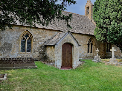
| Description | : | From the leaflet available on the Parish's website: "St. Leonard’s is now in the same parish as St Thomas à Becket, Todenham, and is part of the group of five churches which comprise the Moreton Vale benefice, including also St. David’s Moreton, St. Mary’s Batsford and St. James’s Longborough. Services are held at Easter, Harvest and Christmas, along with the occasional wedding, funeral or bap8sm. But the church is also open every day for visitors". |
frequently asked questions (FAQ):
-
Where is St Leonard's?
St Leonard's is located at Lower Lemington, Moreton-in-Marsh, Gloucestershire, England Moreton-in-Marsh, Cotswold District ,Gloucestershire , GL56 9NREngland.
-
St Leonard's cemetery's updated grave count on graveviews.com?
0 memorials
-
Where are the coordinates of the St Leonard's?
Latitude: 52.0087019
Longitude: -1.6822226
Nearby Cemetories:
1. St Michael and All Angels Church
Great Wolford, Stratford-on-Avon District, England
Coordinate: 52.0091000, -1.6367450
2. St Marys Churchyard
Batsford, Cotswold District, England
Coordinate: 52.0030800, -1.7291600
3. Stretton Cemetery
Stretton-on-Fosse, Stratford-on-Avon District, England
Coordinate: 52.0413935, -1.6733470
4. St. Peter's Churchyard
Stretton-on-Fosse, Stratford-on-Avon District, England
Coordinate: 52.0430778, -1.6754209
5. St Lawrence's Church
Barton-on-the-Heath, Stratford-on-Avon District, England
Coordinate: 51.9918300, -1.6272375
6. St. Peter and St. Paul's Churchyard
Blockley, Cotswold District, England
Coordinate: 52.0124600, -1.7617000
7. St Barnabas & St Nicholas Churchyard
Burmington, Stratford-on-Avon District, England
Coordinate: 52.0393000, -1.6170100
8. St. Mary the Virgin Churchyard
Chastleton, West Oxfordshire District, England
Coordinate: 51.9595360, -1.6395330
9. St. James Churchyard
Longborough, Cotswold District, England
Coordinate: 51.9658220, -1.7407990
10. Shipston Cemetery
Shipston-on-Stour, Stratford-on-Avon District, England
Coordinate: 52.0534039, -1.6225776
11. Saint Peter and St Paul Churchyard
Long Compton, Stratford-on-Avon District, England
Coordinate: 51.9949740, -1.5823690
12. St Paul Churchyard
Broadwell, Cotswold District, England
Coordinate: 51.9476200, -1.7095100
13. Saint Martin's Churchyard
Barcheston, Stratford-on-Avon District, England
Coordinate: 52.0570290, -1.6149230
14. Shipston-on-Stour Friends Burial Ground
Shipston-on-Stour, Stratford-on-Avon District, England
Coordinate: 52.0629460, -1.6232670
15. Saint John The Baptist Churchyard
Cherington, Stratford-on-Avon District, England
Coordinate: 52.0271460, -1.5762520
16. Stourton Wesleyan Chapel Burial Ground
Stourton, Stratford-on-Avon District, England
Coordinate: 52.0303940, -1.5704780
17. St Lawrence Churchyard
Bourton-on-the-Hill, Cotswold District, England
Coordinate: 52.0531830, -1.7758910
18. St James Churchyard
Chipping Campden, Cotswold District, England
Coordinate: 52.0532670, -1.7758760
19. St Catherine's Cemetery
Chipping Campden, Cotswold District, England
Coordinate: 52.0495800, -1.7850600
20. St. Thomas Becket Cemetery
Sutton-under-Brailes, Stratford-on-Avon District, England
Coordinate: 52.0342400, -1.5657800
21. St. Philip Church
Little Rollright, West Oxfordshire District, England
Coordinate: 51.9688330, -1.5742230
22. St Mary's Churchyard
Upper Swell, Cotswold District, England
Coordinate: 51.9398030, -1.7441910
23. St Peter Churchyard
Daylesford, Cotswold District, England
Coordinate: 51.9310080, -1.6479680
24. St. Mary the Virgin Churchyard
Ilmington, Stratford-on-Avon District, England
Coordinate: 52.0892430, -1.6955030