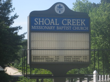
| Memorials | : | 0 |
| Location | : | Hayden, Blount County, USA |
| Coordinate | : | 33.9442659, -86.6672153 |
| Description | : | Small white church on County Road 13 in Hayden right before you cross the Warrior River bridge to Highway 160. Across the river from Plantation Golf Club. |
frequently asked questions (FAQ):
-
Where is Shoal Creek Missionary Baptist Church Cemetery?
Shoal Creek Missionary Baptist Church Cemetery is located at 310 County Highway 13 Hayden, Blount County ,Alabama , 35049USA.
-
Shoal Creek Missionary Baptist Church Cemetery cemetery's updated grave count on graveviews.com?
0 memorials
-
Where are the coordinates of the Shoal Creek Missionary Baptist Church Cemetery?
Latitude: 33.9442659
Longitude: -86.6672153
Nearby Cemetories:
1. Sugar Creek Cemetery
Hayden, Blount County, USA
Coordinate: 33.9379997, -86.6788025
2. High Rock Cemetery
Blount County, USA
Coordinate: 33.9623985, -86.6881027
3. Edgewood Baptist Church Cemetery
Locust Fork, Blount County, USA
Coordinate: 33.9221992, -86.6483002
4. Oak Grove Baptist Cemetery
Hayden, Blount County, USA
Coordinate: 33.9449997, -86.7046967
5. Nectar Cemetery
Nectar, Blount County, USA
Coordinate: 33.9620260, -86.6333680
6. Tabernacle United Methodist Church Cemetery
Locust Fork, Blount County, USA
Coordinate: 33.9025002, -86.6363983
7. Union Grove Cemetery
Hayden, Blount County, USA
Coordinate: 33.9155998, -86.7219009
8. Guinns Cove Cemetery
Bangor, Blount County, USA
Coordinate: 33.9855995, -86.7110977
9. Friendship Baptist Church Cemetery
Hayden, Blount County, USA
Coordinate: 33.9843330, -86.7142230
10. Brown-Hudson Cemetery
Locust Fork, Blount County, USA
Coordinate: 33.9152985, -86.6055984
11. Marsh Cemetery
Locust Fork, Blount County, USA
Coordinate: 33.8993988, -86.6184998
12. Pine Bluff Missionary Baptist Church Cemetery
Locust Fork, Blount County, USA
Coordinate: 33.8978004, -86.6175003
13. Center Hill Independent Presbyterian Cemetery
Blount County, USA
Coordinate: 33.8775650, -86.6581700
14. Greens Chapel Cemetery
Blount County, USA
Coordinate: 33.9606018, -86.5883026
15. Curl Cemetery
Blount County, USA
Coordinate: 34.0113983, -86.6791992
16. Tidwell Cemetery
Deavers Town, Blount County, USA
Coordinate: 33.9272003, -86.5868988
17. Graves Gap Cemetery
Hayden, Blount County, USA
Coordinate: 33.9286003, -86.7491989
18. Gethsemane Baptist Church Cemetery
Hayden, Blount County, USA
Coordinate: 33.8968010, -86.7396011
19. Philadelphia Cemetery Old
Locust Fork, Blount County, USA
Coordinate: 33.8682251, -86.6792221
20. Philadelphia Cemetery New
Locust Fork, Blount County, USA
Coordinate: 33.8690440, -86.6869570
21. Glasscock-Rogers Cemetery
Bangor, Blount County, USA
Coordinate: 33.9734917, -86.7539444
22. Copeland Cemetery
Sky Ball, Blount County, USA
Coordinate: 34.0193670, -86.6379170
23. Old Presbyterian Church Site Cemetery
Blount County, USA
Coordinate: 33.9858340, -86.5832680
24. First Baptist Church of Cleveland Cemetery
Cleveland, Blount County, USA
Coordinate: 33.9898500, -86.5859700

