
| Memorials | : | 0 |
| Location | : | Hooge Zwaluwe, Drimmelen Municipality, Netherlands |
| Coordinate | : | 51.6852900, 4.7486200 |
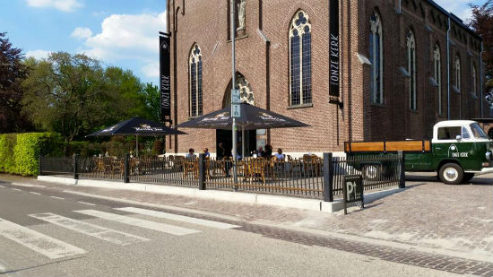
| Description | : | This cemetery is adjacent to the former Sint-Bernarduskerk (Church of Saint Bernard), Hooge Zwaluwe, Noord Brabant, Netherlands. The churchyard is maintained by the village of Hooge Zwaluwe, a suburb of the town of (and government of) Drimmelen. The church, which had fallen into disuse in the late 1970s has been restored, and rebuilt, and is now the home of “Onze Kerk” (Our Church) restaurant and social hall, open daily for meals, or by pre-arrangement for private parties. The former altar area is the location for the café’s kitchen, while the nave, complete with historic slate flooring, has... Read More |
frequently asked questions (FAQ):
-
Where is Sint-Bernardus Kerkhof?
Sint-Bernardus Kerkhof is located at Hooge Zwaluwe, Drimmelen Municipality ,Noord-Brabant ,Netherlands.
-
Sint-Bernardus Kerkhof cemetery's updated grave count on graveviews.com?
0 memorials
-
Where are the coordinates of the Sint-Bernardus Kerkhof?
Latitude: 51.6852900
Longitude: 4.7486200
Nearby Cemetories:
1. Protestantse Begraafplaats Hooge Zwaluwe
Hooge Zwaluwe, Drimmelen Municipality, Netherlands
Coordinate: 51.6909173, 4.7376352
2. Begraafplaats Parochie H Gummarus
Wagenberg, Drimmelen Municipality, Netherlands
Coordinate: 51.6646339, 4.7468280
3. Oude Begraafplaats
Oud-Drimmelen, Drimmelen Municipality, Netherlands
Coordinate: 51.6953428, 4.7815527
4. Made General Cemetery
Made, Drimmelen Municipality, Netherlands
Coordinate: 51.6709734, 4.7794867
5. Oude Begraafplaats
Made, Drimmelen Municipality, Netherlands
Coordinate: 51.6722400, 4.7854625
6. Begraafplaats van de Bernardusparochie
Made, Drimmelen Municipality, Netherlands
Coordinate: 51.6823618, 4.7934563
7. Made-en-Drimmelen Protestant Churchyard
Made, Drimmelen Municipality, Netherlands
Coordinate: 51.6790700, 4.7977900
8. Begraafplaats van de Parochie H Johannes de Doper
Lage Zwaluwe, Drimmelen Municipality, Netherlands
Coordinate: 51.7053186, 4.7091581
9. Begraafplaats Ned Herv Kerk
Lage Zwaluwe, Drimmelen Municipality, Netherlands
Coordinate: 51.7106170, 4.7017214
10. Terheijden Antonius Abt Kerkhof
Terheijden, Drimmelen Municipality, Netherlands
Coordinate: 51.6425700, 4.7518400
11. Rooms-Katholieke Begraafplaats Zevenbergschen Hoek
Zevenbergschen Hoek, Moerdijk Municipality, Netherlands
Coordinate: 51.6740278, 4.6784423
12. R.K. Begraafplaats Heilige Cornelius
Den Hout, Oosterhout Municipality, Netherlands
Coordinate: 51.6600504, 4.8136076
13. Joodse Begraafplaats
Oosterhout, Oosterhout Municipality, Netherlands
Coordinate: 51.6396000, 4.8201600
14. Kerkhof Langeweg
Langeweg, Moerdijk Municipality, Netherlands
Coordinate: 51.6467982, 4.6645953
15. Rooms Katholieke Begraafplaats Moerdijk
Moerdijk, Moerdijk Municipality, Netherlands
Coordinate: 51.7012173, 4.6304095
16. Oosterhout Protestant Cemetery
Oosterhout, Oosterhout Municipality, Netherlands
Coordinate: 51.6415100, 4.8510800
17. Protestantse Begraafplaats Moerdijk
Moerdijk, Moerdijk Municipality, Netherlands
Coordinate: 51.6999519, 4.6233284
18. St. John the Baptist Cemetery
Oosterhout, Oosterhout Municipality, Netherlands
Coordinate: 51.6410220, 4.8616900
19. Begraafplaats Teteringen
Teteringen, Breda Municipality, Netherlands
Coordinate: 51.6112929, 4.8165026
20. Begraafplaats Prinsenbeek
Prinsenbeek, Breda Municipality, Netherlands
Coordinate: 51.6004268, 4.7167543
21. Markendaalse Kerk Cemetery
Breda, Breda Municipality, Netherlands
Coordinate: 51.5887628, 4.7710466
22. Raamsdonk Roman Catholic Cemetery
Raamsdonk, Geertruidenberg Municipality, Netherlands
Coordinate: 51.6875200, 4.9059100
23. Our Lady's Church
Breda, Breda Municipality, Netherlands
Coordinate: 51.5890900, 4.7753160
24. Breda Grote Kerk
Breda, Breda Municipality, Netherlands
Coordinate: 51.5890000, 4.7750000