
| Memorials | : | 0 |
| Location | : | Weert, Weert Municipality, Netherlands |
| Coordinate | : | 51.2544500, 5.7019900 |
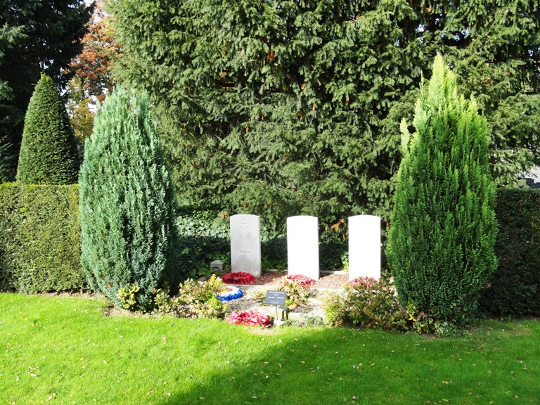
| Description | : | Weert is a town on the main road from Roermond to Eindhoven, 16 kilometres west-north-west of Roermond. The Molenpoort cemetery is on the west side of the town, west of the main road to Eindhoven and 300 metres south of the bridge over the Zuidwillemsvaart canal. Cross the canal and turn into Molenpoort, and the cemetery is along here on the left. Next to the entrance there are 3 graves of british soliers who died 23 September 1944 as the plane they were flying was shot. Not far from them you will find a german grave (shape of a sarcofag) they died... Read More |
frequently asked questions (FAQ):
-
Where is Sint Martinus Kerkhof?
Sint Martinus Kerkhof is located at Weert, Weert Municipality ,Limburg ,Netherlands.
-
Sint Martinus Kerkhof cemetery's updated grave count on graveviews.com?
0 memorials
-
Where are the coordinates of the Sint Martinus Kerkhof?
Latitude: 51.2544500
Longitude: 5.7019900
Nearby Cemetories:
1. Nederweert Saint Lambert Roman Catholic cemetery
Nederweert, Nederweert Municipality, Netherlands
Coordinate: 51.2833328, 5.7500000
2. Nederweert Saint Lambert Roman Catholic cemetery
Nederweert, Nederweert Municipality, Netherlands
Coordinate: 51.2833328, 5.7500000
3. Tungelroij Roman Catholic Churchyard
Tungelroy, Weert Municipality, Netherlands
Coordinate: 51.2126400, 5.7309200
4. Nederweert War Cemetery
Nederweert, Nederweert Municipality, Netherlands
Coordinate: 51.2895400, 5.7500300
5. Swartbroek Churchyard
Swartbroek, Weert Municipality, Netherlands
Coordinate: 51.2298200, 5.7713800
6. Stramproy Rooms-Katholieke Begraafplaats
Stramproy, Weert Municipality, Netherlands
Coordinate: 51.1915100, 5.7259200
7. Budel Dorplein Roman Catholic Cemetery
Budel, Cranendonck Municipality, Netherlands
Coordinate: 51.2391600, 5.5882700
8. Molenbeersel Churchyard
Kinrooi, Arrondissement Maaseik, Belgium
Coordinate: 51.1698500, 5.7374600
9. Hunsel Roman Catholic Churchyard
Hunsel, Leudal Municipality, Netherlands
Coordinate: 51.1883600, 5.8113600
10. Hamont Churchyard
Hamont-Achel, Arrondissement Maaseik, Belgium
Coordinate: 51.2518800, 5.5466300
11. Hamont Centrum Cemetery
Hamont-Achel, Arrondissement Maaseik, Belgium
Coordinate: 51.2542000, 5.5441600
12. Oud Kerkhof Hamont
Hamont, Arrondissement Maaseik, Belgium
Coordinate: 51.2534880, 5.5440170
13. Lozen Cemetery
Bocholt, Arrondissement Maaseik, Belgium
Coordinate: 51.2034200, 5.5623700
14. Kinrooi Cemetery
Kinrooi, Arrondissement Maaseik, Belgium
Coordinate: 51.1469900, 5.7361800
15. Sterksel Monastery Cemetery
Sterksel, Heeze-Leende Municipality, Netherlands
Coordinate: 51.3570900, 5.6228800
16. Bocholt Cemetery
Bocholt, Arrondissement Maaseik, Belgium
Coordinate: 51.1679900, 5.5811600
17. Bree Communal Cemetery
Bree, Arrondissement Maaseik, Belgium
Coordinate: 51.1440200, 5.5994300
18. Abdijkerk
Thorn, Maasgouw Municipality, Netherlands
Coordinate: 51.1606200, 5.8416700
19. Kessenich Churchyard
Kinrooi, Arrondissement Maaseik, Belgium
Coordinate: 51.1509000, 5.8249600
20. Gerdingen Communal Cemetery
Bree, Arrondissement Maaseik, Belgium
Coordinate: 51.1447700, 5.5875100
21. Kaulille Cemetery
Bocholt, Arrondissement Maaseik, Belgium
Coordinate: 51.1885800, 5.5198800
22. Heibloem Cemetery
Heibloem, Leudal Municipality, Netherlands
Coordinate: 51.3004231, 5.9025150
23. Achel Cemetery
Hamont-Achel, Arrondissement Maaseik, Belgium
Coordinate: 51.2559330, 5.4818990
24. Opitter Cemetery
Bree, Arrondissement Maaseik, Belgium
Coordinate: 51.1174200, 5.6406900