
| Memorials | : | 0 |
| Location | : | Appleton, Escambia County, USA |
| Coordinate | : | 31.2453420, -87.1682360 |
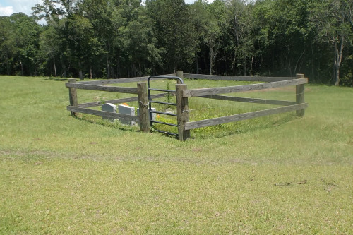
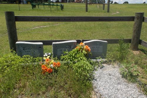
| Description | : | The small cemetery is located off Lowery Landing Road, approximately .7 miles north on the Madden-Smith Loop. The road is paved, but is extremely curvy and should be taken with caution. The cemetery is within walking distance of the pavement, but is behind a cattle fence on private property owned and operated by the Double T Farms. While the gates are not locked, it would be wise and courteous and ask permission before entering the property as the Double T Farms is known for its prized beef and breeding cattle stock and they need to know that... Read More |
frequently asked questions (FAQ):
-
Where is Smith Family Cemetery?
Smith Family Cemetery is located at 1129 Madden-Smith Loop Appleton, Escambia County ,Alabama , 36426USA.
-
Smith Family Cemetery cemetery's updated grave count on graveviews.com?
0 memorials
-
Where are the coordinates of the Smith Family Cemetery?
Latitude: 31.2453420
Longitude: -87.1682360
Nearby Cemetories:
1. Cooper Cemetery
Appleton, Escambia County, USA
Coordinate: 31.2416992, -87.1466980
2. New Hopewell Baptist Church Cemetery
Castleberry, Conecuh County, USA
Coordinate: 31.2752991, -87.1622009
3. Hanberry Cemetery
Wallace, Escambia County, USA
Coordinate: 31.2164001, -87.1808014
4. Smith Plantation Cemetery
Wallace, Escambia County, USA
Coordinate: 31.2418900, -87.2115820
5. Glory Hill Holiness Church Cemetery
Brewton, Escambia County, USA
Coordinate: 31.2656030, -87.1279120
6. Lee Family Cemetery
Range, Conecuh County, USA
Coordinate: 31.2823520, -87.2086800
7. Wallace Church Cemetery
Escambia County, USA
Coordinate: 31.2096996, -87.2213974
8. Oak Grove Holiness Church Cemetery
Sand Cut, Conecuh County, USA
Coordinate: 31.2946790, -87.1328170
9. Hammac Cemetery
Brewton, Escambia County, USA
Coordinate: 31.1893997, -87.1438980
10. Brushy Creek Methodist Church Cemetery
Conecuh County, USA
Coordinate: 31.3067520, -87.1758750
11. Battle Branch Creek Cemetery
Conecuh County, USA
Coordinate: 31.3082716, -87.1516490
12. Calvary Mennonite Church Cemetery
Escambia County, USA
Coordinate: 31.2284270, -87.0948820
13. Martin Cemetery
Brewton, Escambia County, USA
Coordinate: 31.1837190, -87.1056930
14. Weavers Cemetery
Brewton, Escambia County, USA
Coordinate: 31.1828003, -87.1053009
15. Blue Springs Cemetery
Escambia County, USA
Coordinate: 31.2173760, -87.2596790
16. Pleasant Hill Cemetery
Brewton, Escambia County, USA
Coordinate: 31.1655998, -87.2031021
17. Ramah Primitive Baptist Church Cemetery
Lenox, Conecuh County, USA
Coordinate: 31.3302994, -87.1791992
18. Range Cemetery
Range, Conecuh County, USA
Coordinate: 31.3153000, -87.2316971
19. London Cemetery
London, Conecuh County, USA
Coordinate: 31.2964001, -87.0832977
20. Emmons Cemetery East
Escambia County, USA
Coordinate: 31.1849995, -87.2549973
21. Zion Hill Baptist Church Cemetery
Brewton, Escambia County, USA
Coordinate: 31.2171993, -87.0582962
22. Gravel Hill Baptist Church Cemetery
Barnett Crossroads, Escambia County, USA
Coordinate: 31.2132000, -87.2820200
23. Hartwood Methodist Church Cemetery
Conecuh County, USA
Coordinate: 31.3346996, -87.2316971
24. Johnson Cemetery
Range, Conecuh County, USA
Coordinate: 31.3050280, -87.2779330