
| Memorials | : | 0 |
| Location | : | Spring Creek, Madison County, USA |
| Coordinate | : | 35.7696870, -88.6906290 |
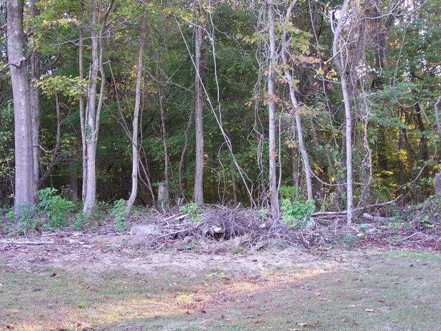
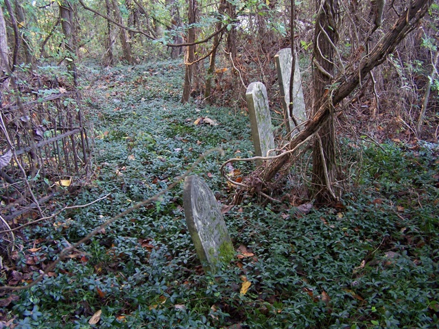
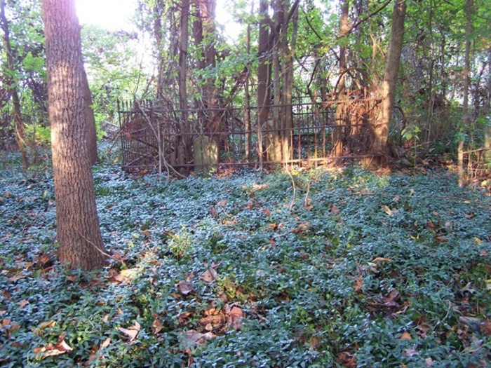
| Description | : | Located on the brow of a sloping ridge about 150 feet north of an access road, that is about 0.1 mile east of US-70 and about 0.3 mile south of the intersection of this highway and TN-152 in the village of Spring Creek. Although there are evidences of numerous graves in this vinca covered burial ground, only two fallen, broken tombstones appear to have survived upright here. Some older citizens recall two large slab tombstones at this location in the 1940s. The Presbyterian Church was located on the southeast side of Spring Creek village. Recent cleaning & rehab... Read More |
frequently asked questions (FAQ):
-
Where is Spring Creek Church Cemetery?
Spring Creek Church Cemetery is located at 159 TN-152 Spring Creek, Madison County ,Tennessee , 38355USA.
-
Spring Creek Church Cemetery cemetery's updated grave count on graveviews.com?
0 memorials
-
Where are the coordinates of the Spring Creek Church Cemetery?
Latitude: 35.7696870
Longitude: -88.6906290
Nearby Cemetories:
1. Hilliard Cemetery
Spring Creek, Madison County, USA
Coordinate: 35.7708200, -88.6906400
2. Gaston Cemetery
Spring Creek, Madison County, USA
Coordinate: 35.7738150, -88.6991500
3. Colonel Taylor's Cemetery
Jackson, Madison County, USA
Coordinate: 35.7732000, -88.6777800
4. Hilliard Cemetery
Madison County, USA
Coordinate: 35.7555000, -88.7111000
5. New Carmel Cemetery
Madison County, USA
Coordinate: 35.7578290, -88.6644070
6. Askew Haughton Cemetery
Madison County, USA
Coordinate: 35.7541670, -88.6655290
7. Donnell Cemetery
Spring Creek, Madison County, USA
Coordinate: 35.7750000, -88.6570000
8. Fellowship Cemetery
Madison County, USA
Coordinate: 35.7477640, -88.7147910
9. Old Carmel Cemetery
Madison County, USA
Coordinate: 35.7476940, -88.7148150
10. Adams Cemetery
Carroll County, USA
Coordinate: 35.7984900, -88.6688400
11. Threadgill Cemetery
Lavinia, Carroll County, USA
Coordinate: 35.8033300, -88.6683300
12. Fly Cemetery
Spring Creek, Madison County, USA
Coordinate: 35.7523870, -88.6484160
13. Burrow Family Cemetery
Lavinia, Carroll County, USA
Coordinate: 35.8089720, -88.6788210
14. Poor House Cemetery
Spring Creek, Madison County, USA
Coordinate: 35.7348520, -88.7229230
15. Madison County Poor House Cemetery
Oakfield, Madison County, USA
Coordinate: 35.7348518, -88.7229233
16. Lathams Chapel Cemetery
Medina, Gibson County, USA
Coordinate: 35.8106530, -88.7107940
17. May Family Cemetery
Spring Creek, Madison County, USA
Coordinate: 35.7216000, -88.6985000
18. Grant-Gaston Cemeteryʌ
Spring Creek, Madison County, USA
Coordinate: 35.7412000, -88.6406000
19. Friendship Baptist Church Cemetery
Madison County, USA
Coordinate: 35.7714500, -88.7530900
20. Gaskins Cemetery
Claybrook, Madison County, USA
Coordinate: 35.7176590, -88.6917720
21. Hopewell Cemetery
Medina, Gibson County, USA
Coordinate: 35.8036003, -88.7406006
22. Davidson Yard Cemetery
Madison County, USA
Coordinate: 35.7542000, -88.7588700
23. Hope Hill Cemetery
Medina, Gibson County, USA
Coordinate: 35.8217010, -88.7221985
24. Hope Hill Cemetery
Medina, Gibson County, USA
Coordinate: 35.8218890, -88.7224110