
| Memorials | : | 0 |
| Location | : | Cromwell, Central Otago District, New Zealand |
| Website | : | ucangparish.co.nz/services/St%20Andrews/st%20andrews.html |
| Coordinate | : | -45.0475370, 169.2098760 |
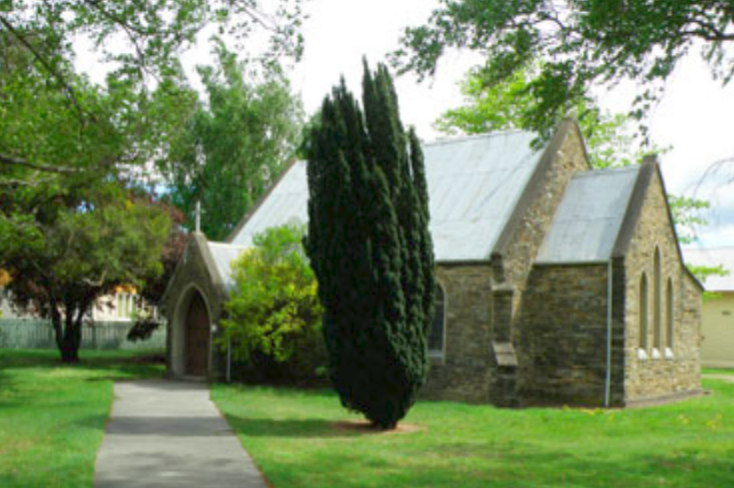
| Description | : | The oldest church building in Cromwell, St. Andrew's Anglican Church, was first planned with the coming of the Rt. Revd. Samuel Neville, Bishop of N.Z. on his pastoral visit to the area in 1873. A committee, headed by Vincent Pike, the Otago Goldfields Secretary, chose the site and began the project which was supported by one of Cromwell's pioneers, John Marsh, who donated the land on which the Church was built. This was contracted to James Taylor, at a cost of 700 pounds, raised by the local community beginning with a parish fair by run by a group of Anglican... Read More |
frequently asked questions (FAQ):
-
Where is St. Andrew's Anglican Church?
St. Andrew's Anglican Church is located at Corner of Blyth and Donegal Streets Cromwell, Central Otago District ,Otago ,New Zealand.
-
St. Andrew's Anglican Church cemetery's updated grave count on graveviews.com?
0 memorials
-
Where are the coordinates of the St. Andrew's Anglican Church?
Latitude: -45.0475370
Longitude: 169.2098760
Nearby Cemetories:
1. Litany Street Cemetery
Cromwell, Central Otago District, New Zealand
Coordinate: -45.0428540, 169.2100400
2. Cromwell Cemetery
Cromwell, Central Otago District, New Zealand
Coordinate: -45.0528700, 169.1732500
3. St. Michael & All Angels Church Cemetery
Clyde, Central Otago District, New Zealand
Coordinate: -45.1887000, 169.3172167
4. Clyde Cemetery
Clyde, Central Otago District, New Zealand
Coordinate: -45.1941880, 169.3398930
5. Cardrona Cemetery
Cardrona, Queenstown-Lakes District, New Zealand
Coordinate: -44.8653020, 169.0172270
6. Alexandra Cemetery
Alexandra, Central Otago District, New Zealand
Coordinate: -45.2397700, 169.3935560
7. Manuherikia Junction Cemetery
Alexandra, Central Otago District, New Zealand
Coordinate: -45.2614850, 169.3977150
8. Nevis Cemetery
Central Otago District, New Zealand
Coordinate: -45.2240700, 168.9529050
9. Tarras Cemetery
Tarras, Central Otago District, New Zealand
Coordinate: -44.8356000, 169.4408100
10. Blacks Cemetery
Omakau, Central Otago District, New Zealand
Coordinate: -45.0895900, 169.6034000
11. Drybread Cemetery
Lauder, Central Otago District, New Zealand
Coordinate: -44.9974100, 169.6075300
12. Arrowtown War Memorial
Arrowtown, Queenstown-Lakes District, New Zealand
Coordinate: -44.9397300, 168.8284300
13. Arrowtown Cemetery
Arrowtown, Queenstown-Lakes District, New Zealand
Coordinate: -44.9402010, 168.8273840
14. Lower Shotover Cemetery
Lower Shotover, Queenstown-Lakes District, New Zealand
Coordinate: -45.0004018, 168.7673740
15. Gorge Creek Miners' Monument
Roxburgh, Central Otago District, New Zealand
Coordinate: -45.3759790, 169.2764350
16. Frankton Cemetery
Queenstown, Queenstown-Lakes District, New Zealand
Coordinate: -45.0155230, 168.7325580
17. Wanaka Cemetery
Wanaka, Queenstown-Lakes District, New Zealand
Coordinate: -44.7040270, 169.1260740
18. Albert Town Cemetery
Wanaka, Queenstown-Lakes District, New Zealand
Coordinate: -44.6797300, 169.1896200
19. Moa Creek Cemetery
Moa Creek, Central Otago District, New Zealand
Coordinate: -45.2102100, 169.6869300
20. Scaife Cemetery
Wanaka, Queenstown-Lakes District, New Zealand
Coordinate: -44.6806570, 169.0616220
21. Queenstown Cemetery
Queenstown, Queenstown-Lakes District, New Zealand
Coordinate: -45.0298090, 168.6554360
22. Skippers Cemetery
Queenstown, Queenstown-Lakes District, New Zealand
Coordinate: -44.8407250, 168.6862270
23. Potters
Roxburgh, Central Otago District, New Zealand
Coordinate: -45.4702550, 169.1115970
24. Hawea Cemetery
Lake Hawea, Queenstown-Lakes District, New Zealand
Coordinate: -44.6134880, 169.2818370