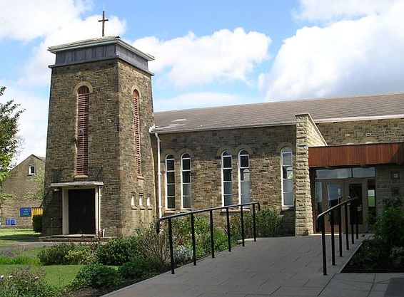
| Memorials | : | 0 |
| Location | : | Bradford, Metropolitan Borough of Bradford, England |
| Website | : | www.joinmychurch.com/churches/St-Andrew-s-Undercliffe-Methodist-Church-Bradford-Bradford-United-Kingdom/325560 |
| Coordinate | : | 53.8082733, -1.7303250 |
| Description | : | Today, the Undercliffe Wesleyan Chapel is known as St. Andrews Methodist Church, Otley Road, Undercliffe, Bradford Bd2 4QP. Located at the junction of A6117 Ring Road (Killinghall Rd) and A658 (Otley Rd). In about 1830 a local society of Wesleyans held meetings in their homes and in the schoolhouse built at Idle Road in 1822. Their first chapel was built in 1835, As membership grew a new larger church was built in 1882 on land, which had sufficient space for expansion, and on this erected a new school in 1913. By 1940 dry rot had made the chapel unsafe and... Read More |
frequently asked questions (FAQ):
-
Where is St Andrew's Undercliffe Methodist Church Graveyard?
St Andrew's Undercliffe Methodist Church Graveyard is located at Otley Road Bradford, Metropolitan Borough of Bradford ,West Yorkshire , BD2 4QPEngland.
-
St Andrew's Undercliffe Methodist Church Graveyard cemetery's updated grave count on graveviews.com?
0 memorials
-
Where are the coordinates of the St Andrew's Undercliffe Methodist Church Graveyard?
Latitude: 53.8082733
Longitude: -1.7303250
Nearby Cemetories:
1. Undercliffe Cemetery
Bradford, Metropolitan Borough of Bradford, England
Coordinate: 53.8040466, -1.7383590
2. Our Lady of Perpetual Succour & St Cla
Bradford, Metropolitan Borough of Bradford, England
Coordinate: 53.8078740, -1.7188450
3. St Luke Churchyard
Bradford, Metropolitan Borough of Bradford, England
Coordinate: 53.8159600, -1.7200700
4. Salem Congregational Chapel Chapelyard
Bradford, Metropolitan Borough of Bradford, England
Coordinate: 53.8191010, -1.7193240
5. Norman Lane Methodist Burial Ground
Idle, Metropolitan Borough of Bradford, England
Coordinate: 53.8232117, -1.7268900
6. Our Lady & St Francis of Assisi Churchyard
Bradford, Metropolitan Borough of Bradford, England
Coordinate: 53.8235700, -1.7343160
7. Bradford Cathedral
Bradford, Metropolitan Borough of Bradford, England
Coordinate: 53.7953600, -1.7479800
8. East Brook Chapel
Bradford, Metropolitan Borough of Bradford, England
Coordinate: 53.7934570, -1.7464240
9. Toad Lane Presbyterian Chapel Graveyard
Bradford, Metropolitan Borough of Bradford, England
Coordinate: 53.7921690, -1.7543550
10. Congregational Chapel
Bradford, Metropolitan Borough of Bradford, England
Coordinate: 53.7910653, -1.7567839
11. St Paul Churchyard
Manningham, Metropolitan Borough of Bradford, England
Coordinate: 53.8069700, -1.7723700
12. St. John's Church, Bowling
Bradford, Metropolitan Borough of Bradford, England
Coordinate: 53.7827200, -1.7322190
13. Thorpe Wesleyan Methodist Chapelyard
Idle, Metropolitan Borough of Bradford, England
Coordinate: 53.8343600, -1.7280700
14. Thorpe Wesleyan Methodist Cemetery
Idle, Metropolitan Borough of Bradford, England
Coordinate: 53.8350900, -1.7259800
15. Upper Chapel Congregational Chapelyard
Idle, Metropolitan Borough of Bradford, England
Coordinate: 53.8371300, -1.7353800
16. Friends Burial Ground
Idle, Metropolitan Borough of Bradford, England
Coordinate: 53.8367910, -1.7397990
17. Upper Chapel Congregational Old Cemetery
Idle, Metropolitan Borough of Bradford, England
Coordinate: 53.8374500, -1.7355600
18. St Margaret's Church of England
Fritzinghall, Metropolitan Borough of Bradford, England
Coordinate: 53.8233290, -1.7730530
19. Upper Chapel Congregational New Cemetery
Idle, Metropolitan Borough of Bradford, England
Coordinate: 53.8375900, -1.7366700
20. Holy Trinity Churchyard
Idle, Metropolitan Borough of Bradford, England
Coordinate: 53.8380900, -1.7318300
21. Windhill Cemetery
Shipley, Metropolitan Borough of Bradford, England
Coordinate: 53.8315100, -1.7694400
22. St Stephen Churchyard
West Bowling, Metropolitan Borough of Bradford, England
Coordinate: 53.7783440, -1.7578570
23. Windhill Wesleyan Methodist Burial Ground
Shipley, Metropolitan Borough of Bradford, England
Coordinate: 53.8326630, -1.7709230
24. St. John the Evangelist Churchyard
Farsley, Metropolitan Borough of Leeds, England
Coordinate: 53.8109500, -1.6720100

