
| Memorials | : | 0 |
| Location | : | Bradford, Metropolitan Borough of Bradford, England |
| Coordinate | : | 53.7910653, -1.7567839 |
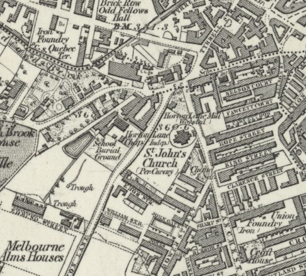
| Description | : | Little Horton Lane Congregational Chapel was opened in 1782 and demolished in the 1960's. Glyde House, which provides the approximate address for the Chapel, was originally a Sunday School. The Congregational Chapel was immediately North-East of the school building, between Glyde House and the statue of Queen Victoria. |
frequently asked questions (FAQ):
-
Where is Congregational Chapel?
Congregational Chapel is located at north-east of Glyde House, Little Horton Lane Bradford, Metropolitan Borough of Bradford ,West Yorkshire , BD5 0BQEngland.
-
Congregational Chapel cemetery's updated grave count on graveviews.com?
0 memorials
-
Where are the coordinates of the Congregational Chapel?
Latitude: 53.7910653
Longitude: -1.7567839
Nearby Cemetories:
1. Toad Lane Presbyterian Chapel Graveyard
Bradford, Metropolitan Borough of Bradford, England
Coordinate: 53.7921690, -1.7543550
2. East Brook Chapel
Bradford, Metropolitan Borough of Bradford, England
Coordinate: 53.7934570, -1.7464240
3. Bradford Cathedral
Bradford, Metropolitan Borough of Bradford, England
Coordinate: 53.7953600, -1.7479800
4. St Stephen Churchyard
West Bowling, Metropolitan Borough of Bradford, England
Coordinate: 53.7783440, -1.7578570
5. Friends Burial Ground
Bradford, Metropolitan Borough of Bradford, England
Coordinate: 53.7788470, -1.7747890
6. St. John's Church, Bowling
Bradford, Metropolitan Borough of Bradford, England
Coordinate: 53.7827200, -1.7322190
7. Undercliffe Cemetery
Bradford, Metropolitan Borough of Bradford, England
Coordinate: 53.8040466, -1.7383590
8. St Paul Churchyard
Manningham, Metropolitan Borough of Bradford, England
Coordinate: 53.8069700, -1.7723700
9. Great Horton Methodist Churchyard
Bradford, Metropolitan Borough of Bradford, England
Coordinate: 53.7813052, -1.7849559
10. St. Matthew Churchyard
Bradford, Metropolitan Borough of Bradford, England
Coordinate: 53.7689950, -1.7638640
11. Bowling Cemetery
West Bowling, Metropolitan Borough of Bradford, England
Coordinate: 53.7714844, -1.7370390
12. St Andrew's Undercliffe Methodist Church Graveyard
Bradford, Metropolitan Borough of Bradford, England
Coordinate: 53.8082733, -1.7303250
13. Scholemoor Cemetery and Crematorium
Bradford, Metropolitan Borough of Bradford, England
Coordinate: 53.7875404, -1.7963200
14. Zion Congregationalist Church Graveyard
Bradford, Metropolitan Borough of Bradford, England
Coordinate: 53.7681900, -1.7702550
15. St. John the Evangelist Churchyard
Bradford, Metropolitan Borough of Bradford, England
Coordinate: 53.7705297, -1.7323057
16. Wibsey Salvation Army Memorial Garden
Wibsey, Metropolitan Borough of Bradford, England
Coordinate: 53.7664200, -1.7702900
17. Our Lady of Perpetual Succour & St Cla
Bradford, Metropolitan Borough of Bradford, England
Coordinate: 53.8078740, -1.7188450
18. St. Paul Churchyard
Wibsey, Metropolitan Borough of Bradford, England
Coordinate: 53.7636700, -1.7784700
19. Daisy Hill Primitive Methodist Chapelyard
Bradford, Metropolitan Borough of Bradford, England
Coordinate: 53.8085600, -1.8007500
20. Heaton Baptist Highgate Cemetery
Heaton, Metropolitan Borough of Bradford, England
Coordinate: 53.8162500, -1.7884300
21. St Luke Churchyard
Bradford, Metropolitan Borough of Bradford, England
Coordinate: 53.8159600, -1.7200700
22. St Margaret's Church of England
Fritzinghall, Metropolitan Borough of Bradford, England
Coordinate: 53.8233290, -1.7730530
23. Holy Trinity Churchyard
Low Moor, Metropolitan Borough of Bradford, England
Coordinate: 53.7564900, -1.7590000
24. North Bierley Municipal Cemetery
Bradford, Metropolitan Borough of Bradford, England
Coordinate: 53.7584470, -1.7781560